|
 |
|
|
 |
| Physical Agents of Land Loss: |
|
|
|
|
|
|
|
|
|
 |
|
|
|
|
|
| Role of Shoreline Characteristics: |
|
|
|
|
| Coastal Morphology & Vegetation |
 |
|
|
|
|
|
|
| Role of Human Activities: |
|
|
|
|
|
|
|
|
|
|
|
|
|
|
|
|
|
|
|
|
|
|
|
|
|
|
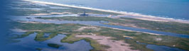
Role of Shoreline Characteristics: Coastal Morphology and Vegetation
The profile and plan-view-shape of the coast also determine its vulnerability to erosion and submergence. The shore type most exposed to wave attack and erosion are tall sea cliffs. On the other hand, sea cliffs can also be the most resistant to erosion if they are composed of rock. Other things being equal, high bluffs of unconsolidated sediment should erode more slowly than low bluffs because high bluffs supply more material for the waves and currents to remove.
For the same reason, sandy beaches with large dunes should erode more slowly than those with low dunes or no dunes. Thieler and Young (1991) showed that in South Carolina, dunes more than 300 m wide and 5 m high were the only ones that were not breached by the storm waves of Hurricane Hugo. Bulkheads and revetments built in place of the dunes were all overstepped and many failed as a result of Hugo's high storm surge. These engineering structures were successful in preventing land loss or shoreline retreat, but offered little protection to the adjacent houses and buildings.
Land loss can also depend partly on smoothness of the coast and continental shelf because it affects wave energy reaching the shore. Wave energy generally increases at promontories and decreases in embayments. As a result, headlands of highly irregular coasts are attacked more vigorously by waves than long stretches of smooth sandy beaches. Wave fetch, nearshore water depths, and shoreline orientation are components of shoreline morphology that also control the wave energy reaching the coast. The greatest coastal land loss normally occurs where there are long fetches of open water, the offshore profile is steep (relatively deep water nearshore), and the waves approach the coast at a relatively high angle.
The density and type of vegetative cover also influences land loss by (1) dissipating the wave energy reaching sheltered shores, (2) encouraging the accumulation of organic and inorganic sediment, and (3) acting as a sediment binder that resists erosion. Some common coastal vegetation habitats are maritime forests, scrub thickets, grassy upland prairies, fresh-water swamps, fresh-water marshes, mangrove swamps, salt-water marshes, and grassy or forested dunes.
Each type of coastal vegetation has its own unique features that can retard land loss. For example, dense stands of salt marsh and mangroves trap sediment or offer resistance to waves and currents so that land loss is prevented or mitigated. Dune grasses also help stabilize blowing sand and can assist in dune enlargement. However, the roots of grasses and trees are generally too shallow to reduce erosion from large storm waves that lower the backbeach and undercut the dunes or uplands.
continue to Role of Human Activities - Introduction
|