Link to USGS home page Link to USGS home page
Coastal and Marine Geology Program
Coastal & Marine Geology Program > South Carolina Coastal Erosion Study > Open File Report 2004-1013

Maps Showing the Stratigraphic Framework of South Carolina's Long Bay from Little River to Winyah Bay

USGS Open File Report 2004-1013

by: Wayne E. Baldwin, Robert A. Morton, Jane F. Denny, Shawn V. Dadisman, William C. Schwab, Paul T. Gayes, and Neal W. Driscoll

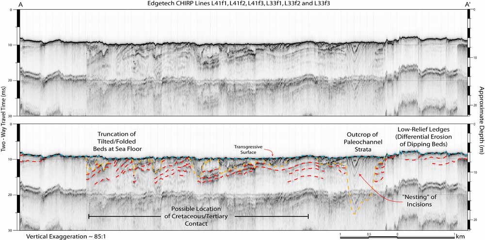
Figure 9. Composite CHIRP sub-bottom profile, with interpretations, from the nearshore area along Surfside Beach where the contact between underlying Cretaceous and Tertiary units has been identified inland. The profile identifies several strong reflections within the underlying continental shelf strata, but does not provide sufficient information for the positive identification of a single reflection representative of the unconformable boundary. Vertical scales for sub-bottom profiles are provided in both milliseconds (Two-Way Travel Time) and approximate depth in meters (assuming a seismic velocity of 1500 m/s). The location for profile A - A' is outlined in Figure 7 and on the inset map in Figure 8.

Printable version of Figure 9.Printable Version of Fig. 9 (17 MB PDF)
Can't see the printable PDF version? Get the free Adobe Acrobat® Reader.

Composite CHIRP sub-bottom profile, with interpretations, from the nearshore area along Surfside Beach where the contact between underlying Cretaceous and Tertiary units has been identified inland.

Coastal & Marine Geology Program > South Carolina Coastal Erosion Study > Open File Report 2004-1013


[an error occurred while processing this directive]