|
|
 |
Seismic Stratigraphy
Cretaceous and Tertiary Shelf Deposits
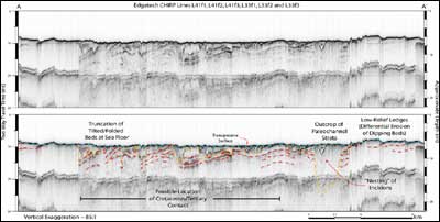
Boomer and CHIRP sub-bottom profiles contain strong, continuous internal reflections interpreted as bedding planes within underlying continental shelf deposits. Previous studies have established Late Cretaceous (Pee Dee Formation) and Paleocene (Black Mingo Group) ages for these strata (Sloan, 1908; Hathaway et al, 1979; Van Niewenhuise and Colquhoun, 1982a,b; Domeracki, 1982; Colquhoun and others, 1983; Owens and Gohn, 1985; Owens, 1990; Idris and Henry, 1995), and have projected the intersection of the Cretaceous/Tertiary boundary with the coast in the Myrtle Beach/Surfside area (Figure 2) (Colquhoun and others, 1983; Owens, 1990). A series of coastal borings conducted for the onshore component of phase II of the SC/GCES verify the existence of the boundary in this vicinity (Figure 8, Putney and others, 2002). Edgetech SB-512 CHIRP data provide high-resolution profiles of the nearshore (~ 500 m) in this area (Figure 9), showing thin to absent surficial sediment overlying differentially eroded continental shelf strata and paleochannel fill. Several strong reflections represent separate units within the underlying shelf strata. It is possible that one of these near-surface reflections represents the unconformity separating Cretaceous from Tertiary, but at this time there is insufficient evidence to resolve this relation.
 |
Figure 8. Three shore-parallel cross sections, generated by Putney and others (2002), incorporating drilling data from Geoprobe, water wells and power auger. Location figure (left) shows position for each of the sections. Boring data from the beach transects indicate approximately 10 - 30 m of Quaternary (Holocene and Pleistocene) sediment overlying older Cretaceous and Tertiary continental shelf deposits. The boundary between underlying Cretaceous/Tertiary units is identified within the central and southern cross sections, and is shown to shallow significantly in the Surfside Beach area, between Geoprobe holes Hor-1 and Hor-3. The position of the nearshore Edgetech SB-512 CHIRP sub-bottom profile A - A' (Figure 9) is also indicated on the location figure (left) (modified from Putney and others, 2002). [larger version] |
 |
| Figure 9. Composite CHIRP sub-bottom profile, with interpretations, from the nearshore area along Surfside Beach where the contact between underlying Cretaceous and Tertiary units has been identified inland. The profile identifies several strong reflections within the underlying continental shelf strata, but does not provide sufficient information for the positive identification of a single reflection representative of the unconformable boundary. Vertical scales for sub-bottom profiles are provided in both milliseconds (Two-Way Travel Time) and approximate depth in meters (assuming a seismic velocity of 1500 m/s). The location for profile A - A' is outlined in Figure 7 and on the inset map in Figure 8. [larger version] |
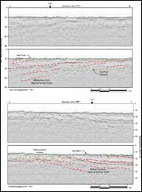
Two stratigraphic observations illustrate regional tectonic influence upon the area. Generally, the continental shelf strata exhibit a gentle dip (~ 0.19°) to the south-southeast throughout Long Bay (Figure 10). The gentle seaward dip (east component) and upward tilt (south component) of these strata result from their position on the southwest flank of the CFA/MCPH, which apparently plunges seaward. Internal antiform and synform structural features (folding) have also been identified, indicating north - south compression of the strata. Varying degrees of deformation are observed. The most distinct folds exist immediately offshore of Waites Island, between Little River and Hog inlets. Shallow sub-surface folds within this region exhibit a maximum relief of ~ 6 m/km (Figure 11). The crests of several antiforms (Figure 11) are truncated by the transgressive unconformity or incised by paleochannels. The location of the paleochannels may be due to extension and fracturing of the strata at the crests of the folds, making them more vulnerable to erosion. Although the cause of the compression generating this deformation is not fully understood, it is likely related to the large-scale regional tectonic processes responsible for uplift of the CFA/MCPH.
 |
Figure 10. Processed boomer sub-bottom profiles with interpretations. These profiles provide both shore parallel (L77F1) and shore perpendicular (L89F1) images of the subsurface. These images illustrate the slight southerly dip of the Tertiary continental shelf strata underlying the area (Deeper Cretaceous strata are likely not imaged). Vertical scales for sub-bottom profiles are provided in both milliseconds (Two-Way Travel Time) and approximate depth in meters (assuming a seismic velocity of 1500 m/s). Locations for lines L77F1 and L89F1 are outlined in Figure 7. [larger version] |
 |
Figure 11. Generalized structure map (top, location outlined in Figure 7) of the nearshore portion of the study area from Cherry Grove to Little River Inlet, which illustrates the folded nature of underlying Cretaceous beds. Folding of this nature is observed throughout the study area, but is particularly prevalent at this location. Below, the CHIRP sub-bottom profile with interpretations (D - D', transect located on inset structure map) shows examples of the varying degrees of relief associated with the folded strata. Also illustrated are examples of folded strata being truncated by the transgressive unconformity, and by paleochannel incision. The high relief antiform structure in the central portion of the profile has been breached at its crest by a paleochannel incision. Thinning and fracturing of the strata at the crest of antiform structures could increase the likelihood of fluvial incision at that location. Vertical scales for sub-bottom profiles are provided in both milliseconds (Two-Way Travel Time) and approximate depth in meters (assuming a seismic velocity of 1500 m/s). [larger version] |
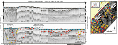
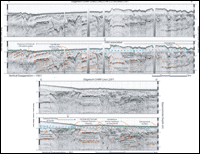
Sea level fluctuation has resulted in truncation or removal of Cretaceous/Tertiary units by subaerial exposure, paleochannel incision, and wave base erosion. Repeated cycles of transgression and regression have generated several unconformities, which are clearly identified within the sub-bottom data. Variation of the seismic signatures associated with these unconformities suggests that the units have undergone differential erosion. Seismic evidence of differential erosion within the Cretaceous/Tertiary units include low-relief hardground ledges, generated by resistant layers being truncated at the seafloor (Figure 12), and variable erosion patterns at the margins of channels (Figure 13). Unconformities generated by both paleochannel incision and transgression serve to identify the upper boundary of the underlying continental shelf strata (Figures 12 and 13).
 |
| Figure 12. Sidescan-sonar coverage overlain by thickness of channel fill (right, location outlined in Figure 7), showing the location and trends of the Cane North and Cane South channels. The composite CHIRP sub-bottom profile with interpretations (E - E') provides subsurface imagery of the two channel features along a nearshore transect (located at right). The seismic example illustrates how cross-sectional morphology (including width and incision depth) and cross shelf morphologies of paleochannel incisions vary within the study area. Vertical scales for sub-bottom profiles are provided in both milliseconds (Two-Way Travel Time) and approximate depth in meters (assuming a seismic velocity of 1500 m/s). [larger version] |
 |
Figure 13. CHIRP sub-bottom profiles with interpretations from offshore Murrells Inlet. The two profiles provide subsurface imagery in shore parallel (Top, F - F') and shore perpendicular (Bottom, G - G') transects (located in figures 7 and 15). Both profiles illustrate the incised valley feature and overlying shoal complex associated with Murrells Inlet. Channels comprising the incised valley demonstrate the variability in cross sectional morphology and complex fill geometries that are observed in type I channel features (F - F' and G - G'). Examples of the geologically younger type II channel features are also illustrated (G - G'). Vertical scales for sub-bottom profiles are provided in both milliseconds (Two-Way Travel Time) and approximate depth in meters (assuming a seismic velocity of 1500 m/s). [larger version] |
continue to Mapping Results: Seismic Stratigraphy - Paleochannel Incision Distribution and Fill Thickness
 |


