Link to USGS home page Link to USGS home page
Coastal and Marine Geology Program
Coastal & Marine Geology Program > Coastal Classification Mapping Project > Open File Report 2004-1044

Coastal Classification Atlas

Eastern Panhandle of Florida Coastal Classification Maps - Lighthouse Point to St. Andrew Bay Entrance Channel

USGS Open File Report 2004-1044

Robert A. Morton, Russell L. Peterson

Report Home Maps Overview Mapping Methods Coastal Classifications Geologic Setting Coastal Processes Coastal Vulnerability Classification Summary References
Introduction || City: Beacon Beach | Long Point | Long Point/Crooked Island | Beacon Hill | Overstreet | St. Joseph Point | St. Joseph Peninsula | Cape San Blas | Indian Pass | West Pass/Cape St. George | Cape St. George | New Inlet | Apalachicola/New Inlet | Goose Island | Carrabelle/Sugar Hill | Carrabelle | Dog Island | McIntyre | St. Teresa | Lighthouse Point
Area: Carrabelle Southwest/Sugar Hill Northwest

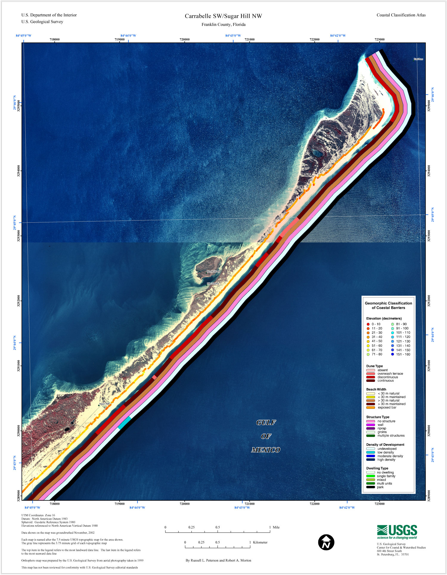
Carrabelle SW/Sugar Hill NW Coastal Classification Map

Map showing the coastal classifications along the eastern panhandle of Florida shoreline. The top item in the legend refers to the most landward data line. The last item in the legend refers to the most seaward data line. Click on the links below to download and view larger versions of the map. At the bottom of the page is a clickable index map that will take you to the other maps.

8 1/2" X 11" (108 KB JPEG)
14" X 18" (283 KB JPEG)
21" X 27" (622 KB JPEG)
  Printable PDF version (11 M PDF)
Can't see the PDF version?
Get Adobe Acrobat® Reader
Coastal classification map for Carrabelle SW/Sugar Hill NW.
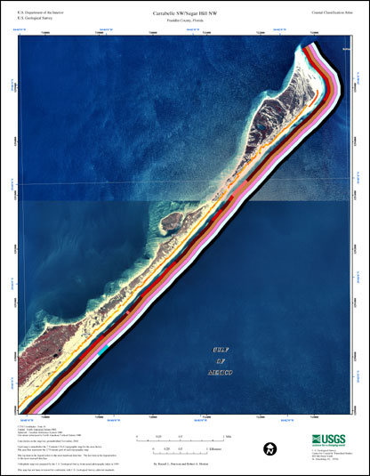
Coastal Classification Map for Carrabelle SW/Sugar Hill NW.
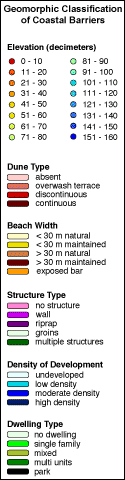
map legend
Map legend.
index map
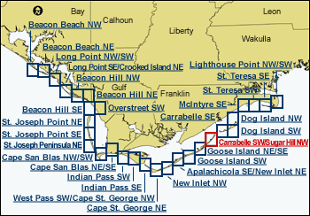
Clickable Index Map. Use the index map above to navigate to the different coastal areas. The selected area is outlined in red.
 

Lighthouse Point NW/SWLighthouse Point NW/SWSt. Teresa SESt. Teresa SESt. Teresa SWSt. Teresa SWMcIntyre SEDog Island NWDog Island SWCarrabelle SECarrabelle SEGoose Island NE/SEGoose Island NE/SEGoose Island SWGoose Island SWApalachicola SE/New Inlet NEApalachicola SE/New Inlet NENew Inlet NWNew Inlet NWCape St. George NECape St. George NEWest Pass SW/Cape St. George NWWest Pass SW/Cape St. George NWIndian Pass SEIndian Pass SEIndian Pass SWIndian Pass SWCape San Blas NE/SECape San Blas NE/SECape San Blas NW/SWCape San Blas NW/SWSt. Joseph Peninsula NESt. Joseph Point SESt. Joseph Point NEOverstreet SWBeacon Hill SEBeacon Hill NEBeacon Hill NWBeacon Hill NWLong Point NE/Crooked Island NELong Point NE/Crooked Island NELong Point NW/SWLong Point NW/SWBeacon Beach NEBeacon Beach NEBeacon Beach NWBeacon Beach NW

Coastal & Marine Geology Program > Coastal Classification Mapping Project > Open File Report 2004-1044


[an error occurred while processing this directive]