Skip past header information
Link to USGS home page.
U.S. Geological Survey Open-File Report 2004-1435

Early to Middle Jurassic Salt in Baltimore Canyon Trough


skip index. Title Page  /  Abstract  /  Introduction  /   Geologic Setting  /   Data Collection  /  Data Processing  /  Geophysical Analysis  /  Discussion  /  Conclusion  /   Bibliography  /  Figures  /  Tables


Printable PDF Format.

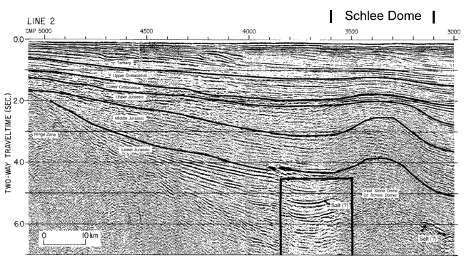
Figure 2A. Interpreted, amplitude-modulated display of wavelet-processed multichannel reflection data. Vertical scale is two-way traveltime in seconds. Boxes show areas enlarged for Figure 3.

Line 2 at the northern end of the Baltimore Canyon Trough shows the negative-polarity lens at about 5.2 s (two-way traveltime) on the landward side of the Schlee Dome and about 5.8 s (two-way traveltime) on the seaward side.

Line 2 at the northern end of the Baltimore Canyon Trough.


Skip Footer Information
FirstGov button  Take Pride in America button