Data Collection
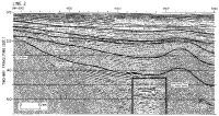
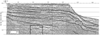
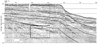
This study is centered on three multichannel reflection dip lines which cross Baltimore Canyon Trough near its northern end (Line 2), its middle (Line 6), and its southern end (Line 10). The lines were acquired between 1973 and 1975 by the M/V Gulf Seal on contract with Digicon Geophysical Corporation using a DFS III acquisition system. Line 2 was shot with a 20-gun array totaling 1260 in3, and Lines 6 and 10 were shot with a 1700-in³ array. The Line 2 streamer array was linear; 24 groups with an interval of 101.2 m and shot intervals of 50.2 m yielded 24-fold data. The maximum offset was 2666 m, and streamer length was 2327.5 m. The data were recorded at a sample rate of 4 ms, and recording filters were set at 8/18-62 Hz. Record length ranged from 7 to 11 s with increasing water depth. Lines 6 and 10 were shot using a 48-channel, 3600 m nonlinear cable with a maximum offset of 3948 m. The far 24 groups had 50-m spacing and the near 24 groups, 100-m spacing, in order to optimize resolution of normal moveout in the far traces. The Line 6 data were recorded at a sample rate of 4 ms and Line 10, 2 ms, with anti-aliasing filters set at 8-62 Hz and 8-124 Hz, respectively. Record length was 11 s in the basin area. Guns were fired at intervals of 50 m. The nonlinear geometry was preserved in processing in order to yield 48-fold data.
|