Geophysical Analysis
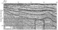
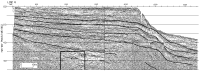
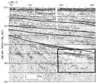
Our study focuses on a single reflector at the top of what Poag (1991) identified as an approximately 12000-km² evaporitic sequence, which presumably includes anhydrite as well (Figure 2 a,b,c). The low-impedance (=velocity x density) layer, apparent as a high-amplitude reflector, is present seaward of the hinge zone (Figure 2), which is composed of rift-faulted (positive-polarity) continental basement rocks that lie stratigraphically well below the lens. The lens is landward of the paleoshelf complex. The lens (Figure 2 and Figure 3) consistently appears as a laterally continuous, high-amplitude trough-peak combination, with a separation of 20-30 ms. It is best resolved on Line 10 (Figure 2c) in the southern end of the basin, where it is underlain by
positive-polarity volcanic rocks. In the mid-basin area (Line 6), the lens is also seaward of the hinge zone and lies about 0.5 s (two-way traveltime) below the oldest carbonate deposits, which form a reef structure (Figure 2b). In the northern end of the basin (Line 2), the lens appears as a disrupted deposit, draped onto both flanks of the Schlee Dome, an Early Cretaceous mafic intrusion (Figure 2a; Jansa and Pe-Piper, 1988). The HOM (Houston Oil and Minerals) 676 well (Figure 1), which was drilled on the flank of the dome, about 10 km southwest of Line 2, penetrated salt at 3.8 km (Oil and Gas Journal, 1978). No age was assigned to the salt unit, but it underlies Kimmeridgian deposits that accumulated in a marginal-marine to nonmarine environment.
The lens thins monotonically toward either end, without any prominent diffractions at the edges. A trough (a negative-polarity feature in the seismic signal) like the one that marks the onset of the lens can generally be interpreted as energy reflected from a boundary between a high-impedance overlying layer and a low-impedance underlying layer. A positive polarity (a peak) generally results from a low-to-high impedance contrast. The interpretation of a trough as a high-to-low impedance contrast event assumes that there has not been a polarity reversal of the waveform, which can result from a variety of circumstances. If we assume that the polarity of a water bottom reflection is a peak, then the low-impedance-layer interpretation fits the trough-peak combination for the lens. However, the lens appears in the section under shallow water depths, where the water bottom reflection does not reveal any consistency of waveform because of the shallow water depth compared to near offset distance. So, as a second check, the polarity of a basement block (Line 10, Figure 2c) was examined; the reflection onset indicates a definite peak amplitude, thus arising from a low-to-high impedance contrast. Similar checks were performed on the Line 2 and 6 hinge-zone sections with consistent results.
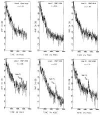
To better delimit the rock type, we estimated reflection coefficients using a true-amplitude processing technique. From these, we estimated the impedance contrast between the encasing rock and the low-impedance layer. The observed amplitude was fit into a power law (t**n, where t is the two-way traveltime and n, the exponent) using the least-squares method. This correction compensates for the reflection's amplitude decay with traveltime caused by geometrical spreading, transmission loss, and attenuation. The amplitude decay analyses for two CMP's in each line are shown in Figure 4, in an area near the low-impedance layer and an area away from the layer. The solutions for n vary from 1.65 to 2.2 near the lens and from 1.73 to 2.16 for CMP's away from the lens. The anomalous amplitudes corresponding to a single trace in the low-impedance layer are 10-20 db higher than the adjacent seismic reflections.
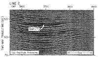
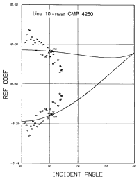
In order to estimate the apparent reflection coefficients, true-amplitude stacked sections were used (Figure 3a,b,c). We used apparent reflection coefficients at this point because we did not compensate for the interference effect of the wavelet. Thus, the estimated reflection coefficient from the true-amplitude section could be higher than the true reflection coefficient when constructive interference occurs and lower with destructive interference. For Line 10 (Figure 3c), the apparent reflection coefficient for the layer at CMP 4270 is estimated at about -0.24 on the basis of the strength of the water bottom reflection near CMP 3240.
For comparison, a forward computation of a reflection coefficient was made assuming a velocity of 4.4 km/s and a density of 2.2 g/cc for the low-impedance layer. From standard velocity analyses, the interval velocities of the upper encasing rock in our sections fall within the range of 5.3 to 5.7 km/s. If corresponding densities of 2.6 to 2.65 g/cc are assumed, then the reflection coefficient for the low-impedance layer would lie between -0.17 and -0.22.
Overpressured shale or gas-saturated sediments would also generate a normal-incidence reflection coefficient of this order of magnitude. To better constrain the lithological interpretation that has been based so far only on the observed polarity, reflection strength, and velocities, we attempted amplitude versus offset (AVO) analysis of CMP gathers for Line 10. It was based on the fact that for oblique or non-normal incidence, the reflection coefficient varies as a function of incidence angle. The AVO analysis allows for quantitative estimates of the lithology using pre-stack amplitude information. The amplitude variations are indicative of layer characteristics because they are a function of the medium's physical parameters and elastic properties. A plot of estimated reflection coefficients versus angles of incidence was examined; it included both positive and negative reflection coefficients to test alternate rock types for the low-impedance layer. These data (shown in Figure 5) were analyzed using a generalized linear inversion method to estimate the elastic parameters. Only Line 10 data were used because the Line 2 offset was too small (less than 10 degrees) and the Line 6 data had an F-K filter applied to part of the section (the top 3 s). The solutions shown are the best based on a least-squares fit (Figure 5). There are large differences between the observed and computed values, which are shown in Figure 5. One problem with the inversion was that the field configuration, yielding a maximum offset of 3.5 km, and the target depth of about 10 km, only provide a maximum incident angle of about 14 degrees, even accounting for a curved ray path. This limited coverage, coupled with the large scatter of observed reflection coefficients, makes the inversion result fairly sensitive to the initial guess. The root-mean-square (RMS) error of the inversion results is 0.04 for the negative reflection coefficient and about 0.045 for the positive reflection coefficient. Though limited by these factors, the observed reflection coefficients do decrease with respect to increasing offset. This relation may eliminate gas-saturated sediments as a possible cause of the low-impedance layer. On the basis of all the inversion results, the low-impedance layer is characterized by low density, and solutions cluster around a value of 2.18 g/cc. This low density could rule out the possibility that overpressured shale causes the low-impedance contrast layer.
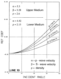
A very low shear velocity for the high-amplitude lens, 1.32 km/s, also is indicated by the inversion results (Table 2). Given the small incidence angle, less than fourteen degrees, and the large amount of scatter in the observed data input to the inversion, the S-wave velocity solution is not well constrained. Because of the paucity of S-wave velocity data for salt, we cannot be certain whether the inversion-derived S-wave velocity of 1.32 km/s is feasible. Ryder and others (1981) worked with data from the Paradox basin, Utah, where a P-wave velocity of 4.78 km/s and a shear-wave velocity of 2.7 km/s were determined for a salt dome; however, the velocities for a salt dome and that for a horizontal layer may differ substantially. This low shear velocity may cause the rapid decrease of observed reflection amplitude. Given a constant P-wave velocity and density, reflection coefficients were computed for four different shear velocities, and all demonstrate the rapid decrease of reflection coefficient with increased incidence angle (Figure 6). The results from this study and those of Ramirez (1990) for interbedded salt layers in the Gulf of Mexico show the same AVO trend, which is a rapid decay in amplitude with increased incidence angle.
Positive reflection coefficients, corresponding to a lithology of dense anhydrite or an igneous intrusion, were tested in the inversion as well (Figure 6). Though neither positive nor negative coefficients yielded a good fit to the observed values, the negative reflection coefficients fit the trend better.
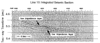
Integration of the true-amplitude-processed section enhances the relative impedance contrasts of the reflections of the lens on Line 10 and shows the marked low-impedance layer (Figure 7). An integrated seismic section mimics the impedance log within a given frequency band, where a left swing indicates low impedance and a right swing, high impedance. On Line 10, there is a significant low-impedance zone near CMP 4250, which progressively decreases in amplitude away from CMP 4250. The apparent high negative amplitude (left swing) at CMP 4250 is interpreted as a constructive interference effect. The decreasing amplitude is due to the thinning of the lens. The apparent reflection coefficient estimate is about 0.28 for CMP 4250, about 0.1 for CMP 4030, and 0.13 for CMP 4430.
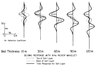
This apparent variation in reflection coefficient values is explained using one-dimensional modeling. In Figure 8, the spikes represent the impulse responses of the lens (P-wave velocity = 4.4 km/s; density = 2.2 g/cc) encased in a medium of P-wave velocity = 5.3 km/s and density = 2.6 g/cc. Various layer thicknesses, ranging from 10 to 120 m, convolved with a 15 Hz Ricker wavelet, which corresponds to the dominant frequency of the seismic section, are modeled. A lens less than 25 m thick shows destructive interference. For a bed about 25-100 m thick, there is constructive interference.
Trough-peak separation times also vary with bed thickness. The observed trough-peak separation is on the order of 30 ms. That value, coupled with the observed reflection amplitudes, suggests a lens thickness of about 60 m near CMP 4250, thinning to less than about 20 m near CMP's 4030 and 4430, and zero thickness near CMP 4000 and 4470.
A second lens may exist underneath the one described. This deeper anomaly shows a less pronounced impedance contrast than the upper one. The deeper anomaly shows a trough-peak separation of about 40 ms. But there is complex interference from peg-leg multiples from the upper lens. This interference, coupled with the general seismic character of a deeper horizon makes identification tenuous. Our preferred interpretation is that there is only one lens.
|