|
|
|
|
|
| Report Home | Maps | Overview | Mapping Methods | Coastal Classifications | Geologic Setting | Coastal Processes | Coastal Vulnerability | Classification Summary | References | |||||||||||||||||||||||||||||||
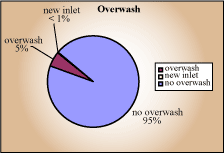
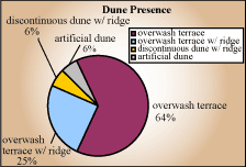
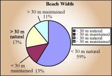
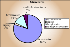
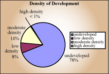
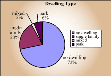
Classification SummaryThe coastal classification maps provide a basis for establishing the lengths of shore that have a particular morphological characteristic or cultural attribute. Such information is relevant for local and state governments for planning that involves the amount of shore that is developed versus undeveloped, or the amount of parkland held in the public trust. Also there is interest regarding the amount of shore that is affected by engineering structures, referred to as armoring or hardening of the shore. Environmental protection and resource management issues such as these require quantitative data that can be derived from the classification maps. The shore lengths and equivalent percents of the 43 km segment of coast between Abel Pass and East Timbalier Island are presented for each classification unit in Table 2. Seventy eight percent of this coastal segment is undeveloped, and where it is developed, the development is mostly moderate density (Table 2). Single-family homes are more common than multi-family units such as motels, and 6% of the shore is classified as parks (Table 2). This number is slightly low if the small beach-access parking lots along Grand Isle are included in the "park" category. Areas of complete storm overwash represent only about 5% of the shore, but an overwash terrace occupies about 89% of the shore (Table 2), indicating high vulnerability to storm impacts. To protect against storm waves and flooding, a moderately high artificial dune ridge was constructed on Grand Isle that in its natural state would have been classified as continuous dunes. Nearly 60% of the shore is characterized by natural beaches less than 30 m wide (Table 2). Because the beaches on Grand Isle are prime recreational areas for southcentral Louisiana, the beaches are maintained, representing about 24% of the total beach length (Table 2). Twenty percent of the shore is influenced by hard structures (Table 2); most of the structures are offshore segmented breakwaters with some riprap revetments and geotubes built in the backbeach along Grand Isle and at Fourchon.
|