

South Carolina Aeromagnetic Surveys
Index Map of Aeromagnetic Surveys
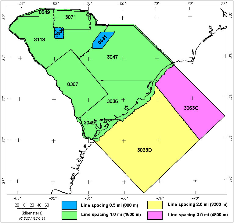
The South Carolina composite aeromagnetic map contains data from 11 aeromagnetic surveys as shown in the above index map. The survey numbers are keyed to the table below.
Flight line data for the digitally recorded surveys (data type=digital) are available from a USGS web site: http://pubs.usgs.gov/of/2002/ofr-02-361/ (U.S. Geological Survey and National Geophysical Data Center, 2002)
Analog survey data (data type=analog) are available from USGS web site: http://pubs.usgs.gov/of/1999/ofr-99-0557/html/mag_home.htm (U.S. Geological Survey, 1999)
Survey Facts
|
|
|
|
Flown by |
|
|
|
|
|
|
References |
| 0307 | Analog | Savannah ARMS | USGS | 07/1958-08/1958 | 1 mi. | NW-SE | 500 ft AG | 10,000 | Total field, arbitrary datum | USGS GP-489 |
| 0549 | Analog | Southern Knoxville | USGS | 06/1965 | 1 mi. | E-W | 6000 ft B | 4330 | Total field, arbitrary datum | USGS OF66-140 |
| 0631 | Analog | Haile Brewer | USGS | 12/1967 | 0.5 mi. | E-W | 400 ft AG | 1245 | Total field, arbitrary datum | USGS OF70-334 |
| 3034 | Digital | Enoree | Airmag | 08/1973-10/1973 | 0.5 mi. | NW-SE | 500 ft AG | 500 | IGRF65 | USGS OF75-051 |
| 3035 | Digital | Southern South Carolina | Airmag | 08/1973-10/1973 | 1 mi. | N-S | 500 ft AG | 5800 | IGRF65 | USGS OF75-590 |
| 3047 | Digital | Northeast South Carolina | GeoMet. | 12/1974-02/1975 | 1 mi. | E-W | 500 ft AG | 9630 | IGRF65 | USGS OF76-181 |
| 3049 | Digital | South Carolina-Georgia Border | GeoMet. | 10/1974-11/1974 | 1 mi. | E-W | 500 ft AG | 2800 | IGRF65 | USGS OF76-155 |
| 3063C | Digital | Offshore East Coast Central | LKB | 11/74-10/75 | 3 mi. | NW-SE | 1500 ft B | 19900 | IGRF65 | USGS GP-931 |
| 3063D | Digital | Offshore East Coast South | LKB | 01/75-12/75 | 2 mi. | NW-SE | 1500 ft B | 41700 | IGRF65 | USGS GP-931 |
| 3071 | Digital | North-central South Carolina | GeoMet. | 07/1975 | 1 mi. | E-W | 500 ft AG | 1764 | IGRF65 | USGS OF77-252 |
| 3118 | Digital | Northwest South Carolina | LKB | 1977-1978 | 1 mi. | E-W | 500 ft AG | 7985 | IGRF75 | USGS OF78-847 |
Description of Table headings:
Survey No.: Internal USGS identification number
Data Type: Survey data were recorded in flight as analog or digital
Survey Name: Internal project name (not always the name used in publication
title)
Flown By: Company or government agency who flew the original survey
Flight Spacing and Flight Direction: Primary flight-line spacing and primary
flight-line direction
Flight Altitude: Primary flight altitude ; B = barometric elevation, AG =
above ground draped over topography
Flight-Line Miles: Approximate total of line miles flown for this survey
Field, Datum: Indicates if a regional field was removed and, if it could be
determined, the base value removed. Total field = no regional was removed. Arb.
(arbitrary) datum = the base value removed was not stated on the map or in
survey reports.
References: Brief publication reference. USGS publications
are listed as: Open-File reports = OFxx-yyyy where xx is the publication year,
Bulletins and Professional Papers = B-yyyy or P-yyyy, Geophysical Maps = GP-yyyy,
Miscellaneous Field Studies Maps = MF-yyyy.
|| Top || Page 1 || Compilation || Processing || Gravity Map || Download data || References ||
USGS Links: || USGS Eastern Minerals Team || USGS Geologic Discipline || USGS home page ||