USGS Open-File Report 2005-1231
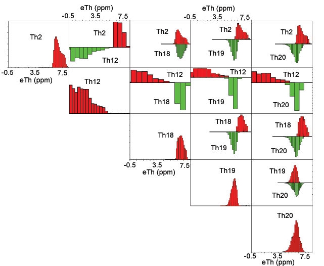
Some of the classes appear to be related to the occurrence of water. Class R12 clearly reflects the presence of water as determined by comparison to maps showing the locations of lakes and larger ponds. Classes R02, R18, R19, and R20 often occur around or adjacent to areas of class R12 (see the classification map) which suggests that they may be related in some manner. Figure 1 shows a matrix of histograms comparing the potassium distributions of classes R02, R12, R18, R19, and R20. Figure 2 shows a matrix of histograms comparing the uranium distributions. Figure 3 shows a matrix of histograms comparing the thorium distributions.
The distributions of all three elements are largely overlapping for classes R02 and R18 and they almost always occur adjacent to one another. Classes R19 and R20 have similar distributions of potassium and thorium but their uranium distributions are reasonably distinct. An indication that classes R19 and R20 are closely related is that they almost always occur adjacent to one another (see the classification map). Most of the areas of classes R19 and R20 coincide with locations where the survey aircraft flew at effective altitudes greater than 200 m (refer to the map showing areas of high survey altitudes).
Class R12 has a very distinct signature with generally lower concentrations of the three elements. A lot of the values are close to zero which are the expected concentrations for water. The fact that many of the values are positive values much greater than zero is a reflection of the mixed signal from areas of soil and water. The nominal survey altitude was 152 m and the area measured by the gamma-ray system at intervals of one second was about 300 m wide and about 400 m along the flight path. Because the system integrates the gamma-ray flux along the flight path and because the flux of gamma-rays contributing to the measurement decreases exponentially as the distance from the aircraft increases (refer to Duval, Cook and Adams, 1971), the measurement over a body of water smaller than a diameter of about 300 m will include gamma rays from the surrounding soils. Any grid cells with mixed measurements of water and soil will not be classified correctly. Because classes R02, R18, R19, and R20 often occur around areas of class R12, those particular grid cells probably reflect mixed water-soil measurements. Classes R04 and R17 also sometimes occur around areas of class R12. Wherever these classes occur together or in relatively small and isolated areas, they may be an indication of higher water content or the presence of small bodies of water.
Figure 1. Matrix of histograms comparing the potassium distributions of classes R02, R12, R18, R19, and R20. The horizontal scales are identical for all of the graphs but the vertical scales vary. The vertical axis shows the frequency of ranges of potassium concentrations. The bin sizes used to calculated the histograms also vary.
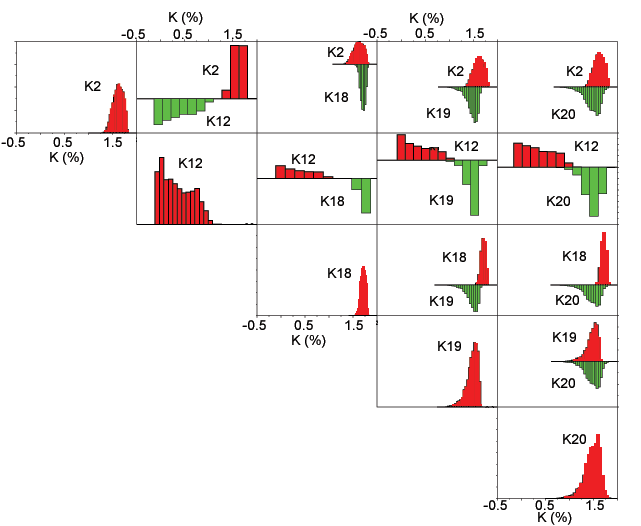
Figure 2. Matrix of histograms comparing the uranium distributions of classes R02, R12, R18, R19, and R20. The horizontal scales are identical for all of the graphs but the vertical scales vary. The vertical axis shows the frequency of ranges of uranium concentrations. The bin sizes used to calculated the histograms also vary.
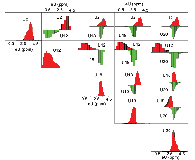
Figure 3. Matrix of histograms comparing the thorium distributions of classes R02, R12, R18, R19, and R20. The horizontal scales are identical for all of the graphs but the vertical scales vary. The vertical axis shows the frequency of ranges of thorium concentrations. The bin sizes used to calculated the histograms also vary.

![]() U.S. Department of the Interior |
U.S. Geological Survey
U.S. Department of the Interior |
U.S. Geological Survey
URL: http://pubsdata.usgs.gov/pubs/of/2005/1231/WaterClasses.htm
Page Contact Information: Stephen Snyder
Page Last Modified: Saturday, 12-Jan-2013 21:28:35 EST