USGS Open-File Report 2005-1231
This section discusses a group of classes selected because they might be related to the Lissie Formation (Ql) or dune sand deposits (Qds). Figure L1 shows a matrix of potassium distributions comparing classes R05, R11, R13, and R16. Figure L2 shows a matrix of the uranium histograms and figure L3 shows a matrix of the thorium histograms.
For class R05, the potassium distribution overlaps that of class R16 but has little overlap with the potassium distributions of classes R11 and R13. The uranium distribution of class R05 overlaps the uranium distributions of all of the other classes in this group. The thorium distribution of R05 overlaps that of R11, has some overlap with the thorium distribution of class R13, and does not overlap that of R16. Class R05 occurs in relatively large areas throughout much of the middle part of the survey area and frequently has class R13 adjacent to it or embedded within it (refer to the classification map). About 37 percent of the class occurs in areas mapped as dune sands (Qds), about 22 percent as Lissie Formation, and about 28 percent in areas mapped as Goliad Formation (see Table 1 of geology comparisons).
For class R11, the potassium distribution overlaps that of class R13 but has little overlap with the potassium distributions of classes R05 and R16. The uranium distribution of class R11 overlaps the uranium distributions of all of the other classes in this group. The thorium distribution of R11 overlaps that of R05, has some overlap with the thorium distribution of class R13, and does not overlap that of R16. Class R11 occurs in relatively small areas and is widely distributed across much of the survey area. It is sometimes associated with class R13 but is more commonly associated with classes R01, R03, and R08 (refer to the classification map). About 43 percent of the class occurs in areas mapped as dune sands (Qds), about 14 percent in areas mapped as Beaumont floodplain deposits (Qbf), about 17 percent in areas mapped as clay and mud deposits of the Beaumont Formation (Qbm), and about 16 percent in areas mapped as Lissie Formation (Ql) (see Table 1 of geology comparisons).
For class R13, the potassium distribution overlaps that of class R11 but has little overlap with the potassium distributions of classes R05 and R16. The uranium distribution of class R13 overlaps the uranium distributions of all of the other classes in this group. The thorium distribution of R13 exhibits some overlap with the thorium distributions of classes R05 and R11 but has little overlap with that of R16. Class R13 is widely scattered throughout much of the middle part of the survey area but does not have any patterns that are particularly consistent with any of the mapped geologic units. Much of an area mapped as dune sand in Cameron county on the eastern side of the survey area is classified as R13. About 59 percent of class R13 occurs in areas mapped as dune sands and about 17 percent in areas mapped as Lissie Formation (see Table 1 of geology comparisons).
For class R16, the potassium distribution overlaps that of class R05 but has little overlap with the potassium distributions of classes R11 and R13. The uranium distribution of class R16 overlaps the uranium distributions of all of the other classes in this group. The thorium distribution of R16 has little overlap with the thorium distributions of the other classes in this group. Class R16 occurs mostly in the northern part of the survey area with small areas scattered elsewhere. About 79 percent of class R16 occurs in areas mapped as Goliad Formation (Tg), about 8 percent in areas mapped as dune sand (Qds), and about 13 percent in areas mapped as Lissie Formation (Ql) (see Table 1 of geology comparisons).
All together these four classes only account for about 53 percent of areas mapped as dune sand and about 61 percent of areas mapped as Lissie Formation. Class R05 by itself accounts for about 25 percent of areas mapped as Qds and about 35 percent of areas mapped as Lissie Formation (refer to Table 1 of geology comparisons).
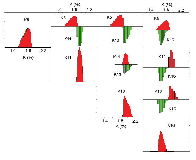
Figure L1. Matrix of potassium bi-histograms for classes related to Lissie Formation or sand dunes. The number denotes the class (refer to the classification map).
[Figure L1] [Figure L2] [Figure L3]
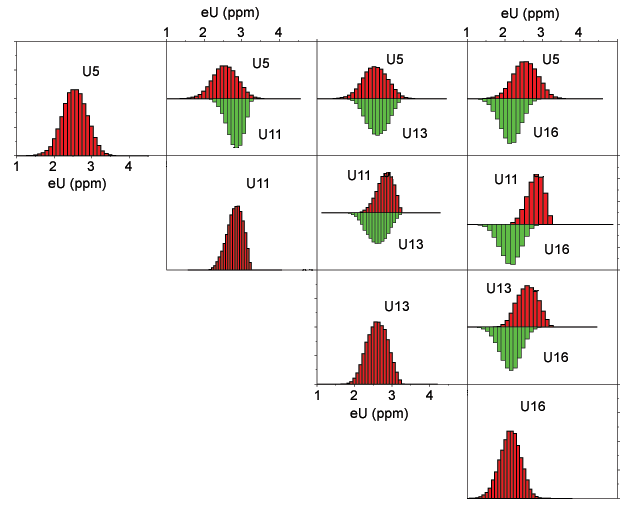
Figure L2. Matrix of uranium bi-histograms for classes related to Lissie Formation or sand dunes. The number denotes the class (refer to the classification map).
[Figure L1] [Figure L2] [Figure L3]
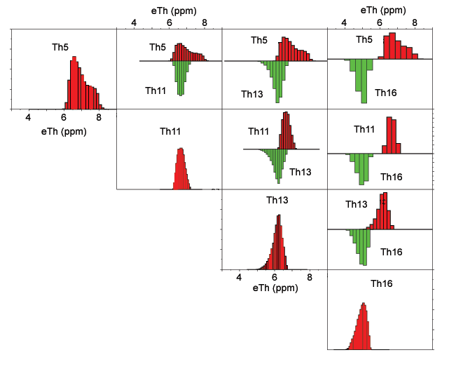
Figure L3. Matrix of thorium bi-histograms for classes related to Lissie Formation or sand dunes. The number denotes the class (refer to the classification map).
[Figure L1] [Figure L2] [Figure L3]

![]() U.S. Department of the Interior |
U.S. Geological Survey
U.S. Department of the Interior |
U.S. Geological Survey
URL: http://pubsdata.usgs.gov/pubs/of/2005/1231/lissiegrp.htm
Page Contact Information: Stephen Snyder
Page Last Modified: Saturday, 12-Jan-2013 21:28:09 EST