USGS Open-File Report 2005-1231
This sections discusses comparisons of geologic units that are mapped in the area of the aerial gamma-ray survey. Polygons representing each mapped unit were used to determine the numbers of grid cells identified with each of the classes defined by the classification of the data. The data for the numbers of grid cells for each class were plotted in a histogram with the histogram bars colored according to the color used on the classification map. Figure C1 shows the preliminary geologic map used (from the map by Page, VanSistene, and Turner, 2005). The shading indicates areas outside of the aerial survey. Click on the map to view it at a higher resolution and click here to open the map legend in a separate window. The geologic units are discussed separately below and the results are summarized.
[Qas] [Qam] [Qds] [Qb] [Qbf] [Qbm] [Ql] [Tg] [Summary]
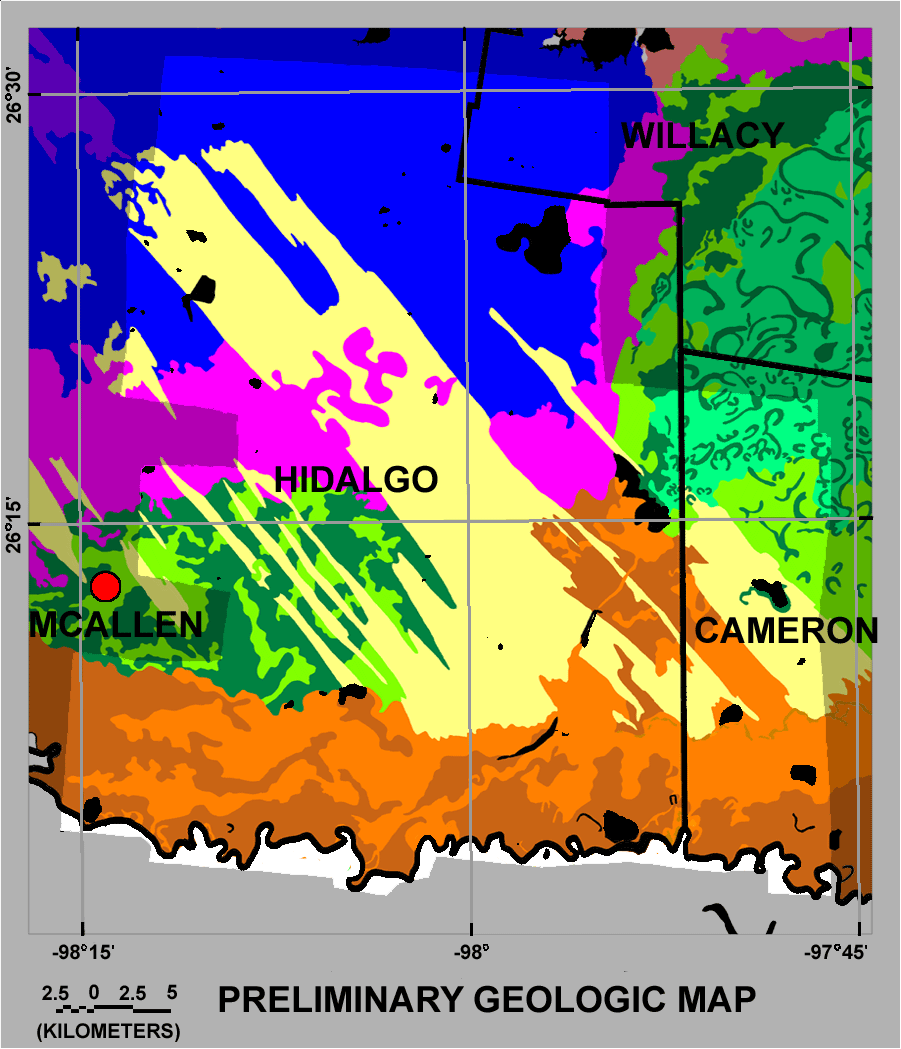
Figure C1. Preliminary geologic map of the survey area (from the map by Page, VanSistene, and Turner, 2005). The shading indicates areas that are outside the area of the aerial survey. Click on the map to view it at a higher resolution and click here to open the map legend in a separate window.
Figure C2 below shows the results for the Holocene unit designated as Qas, The classes with the largest numbers of grid cells associated with this geologic unit are R07 and R20. Each of classes R01, R02, R09, R10, R15, and R18 also have more than 5,000 grid cells within the areas mapped as unit Qas. Figure C3 shows the data presented as the fraction of each class that occurs within the areas mapped as Qas. More than 20 percent of classes R02, R07, R09, R10, R12, R15, R18, and R21 occur within the areas mapped as Qas.
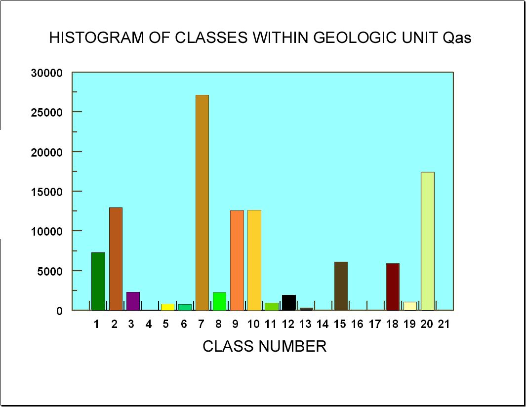
Figure C2. Graph of histogram of the number of grid cells within geologic unit Qas assigned to the various classes.
[Qas] [Qam] [Qds] [Qb] [Qbf] [Qbm] [Ql] [Tg] [Summary]
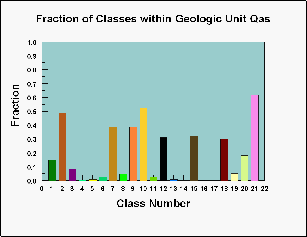
Figure C3. Graph of the fraction of the various classes within geologic unit Qas.
[Qas] [Qam] [Qds] [Qb] [Qbf] [Qbm] [Ql] [Tg] [Summary]
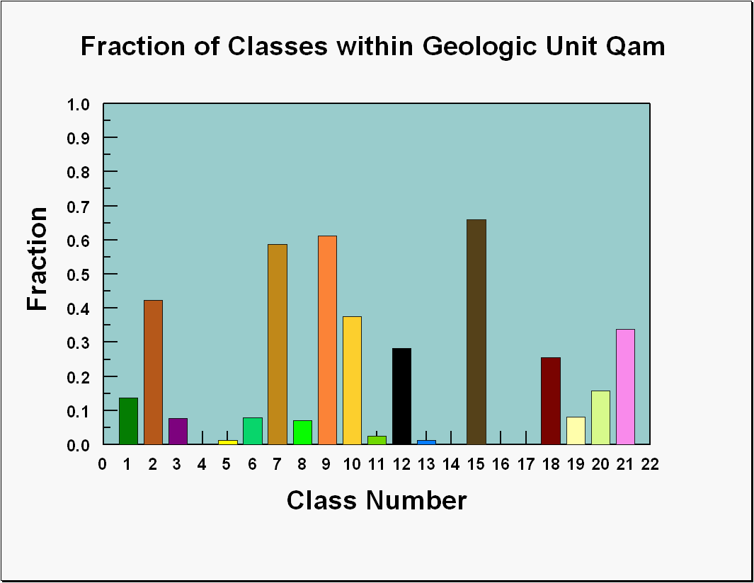
Figure C4 shows the graph of the numbers of grid cells of each class within the areas mapped as the Holocene unit designated as Qam. The class most frequently associated with this geologic unit is R07. Each of classes R01, R02, R09, R10, R15,R18, and R20 also have more than 5,000 grid cells within the areas mapped as unit Qam. Figure 5 shows the data presented as the fraction of each class that occurs within the areas mapped as Qam and more than 20 percent of classes R02, R07, R09, R10, R12, R15, R18, and R21 occur in those areas.
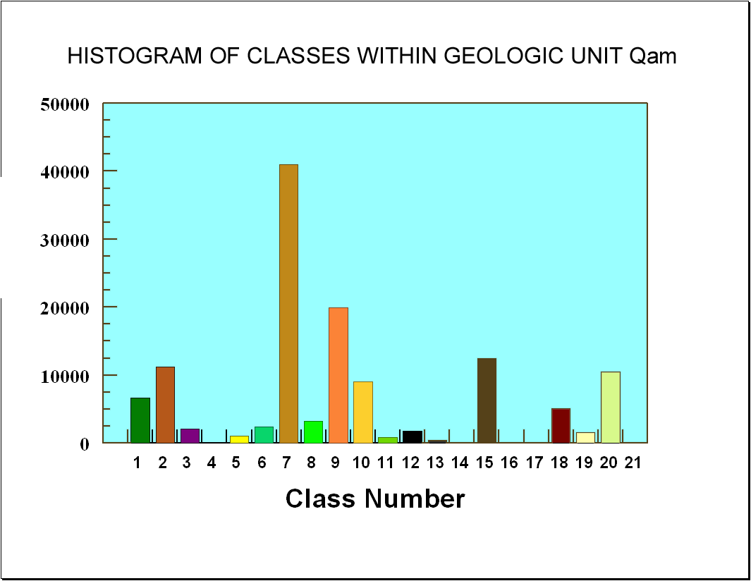
Figure C4. Graph of histogram of the number of grid cells within geologic unit Qam assigned to the various classes.
[Qas] [Qam] [Qds] [Qb] [Qbf] [Qbm] [Ql] [Tg] [Summary]
[Qas] [Qam] [Qds] [Qb] [Qbf] [Qbm] [Ql] [Tg] [Summary]
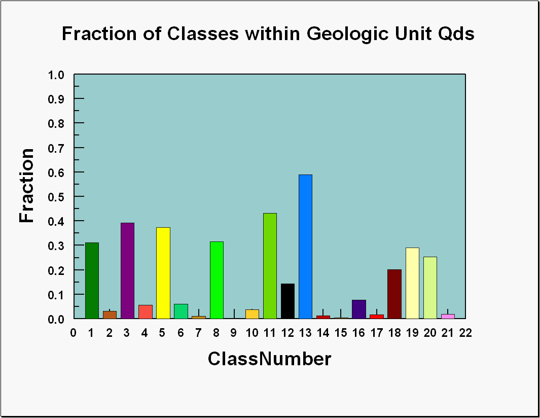
Figure C6 shows the graph of the numbers of grid cells of each class within the areas mapped as the Holocene unit designated as Qds. The classes most frequently associated with this geologic unit are R05 and R13. Each of classes R01, R03, R08, and R11 also have more than 7,000 grid cells within the areas mapped as Qds. Figure C7 shows the data presented as the fraction of each class that occurs within the areas mapped as Qds and more than 20 percent of classes R01, R03, R08, R11, R13, R19, and R20 occur in those areas.
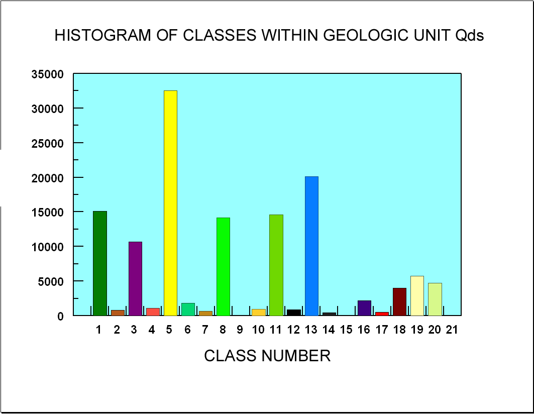
Figure C6. Graph of histogram of the number of grid cells within geologic unit Qds assigned to the various classes.
[Qas] [Qam] [Qds] [Qb] [Qbf] [Qbm] [Ql] [Tg] [Summary]
[Qas] [Qam] [Qds] [Qb] [Qbf] [Qbm] [Ql] [Tg] [Summary]
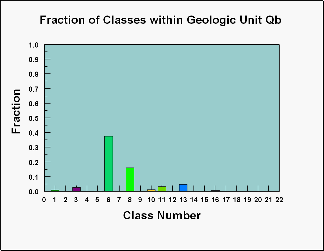
Figure 8 shows the graph of the numbers of grid cells of each class within the areas mapped as undivided Beaumont Formation (Qb), The classes most frequently associated with this geologic unit are R06 and R08. Figure 9 shows the data presented as the fraction of each class that occurs within the areas mapped as Qb and more than 16 percent of classes R06 and R08 occur in those areas.
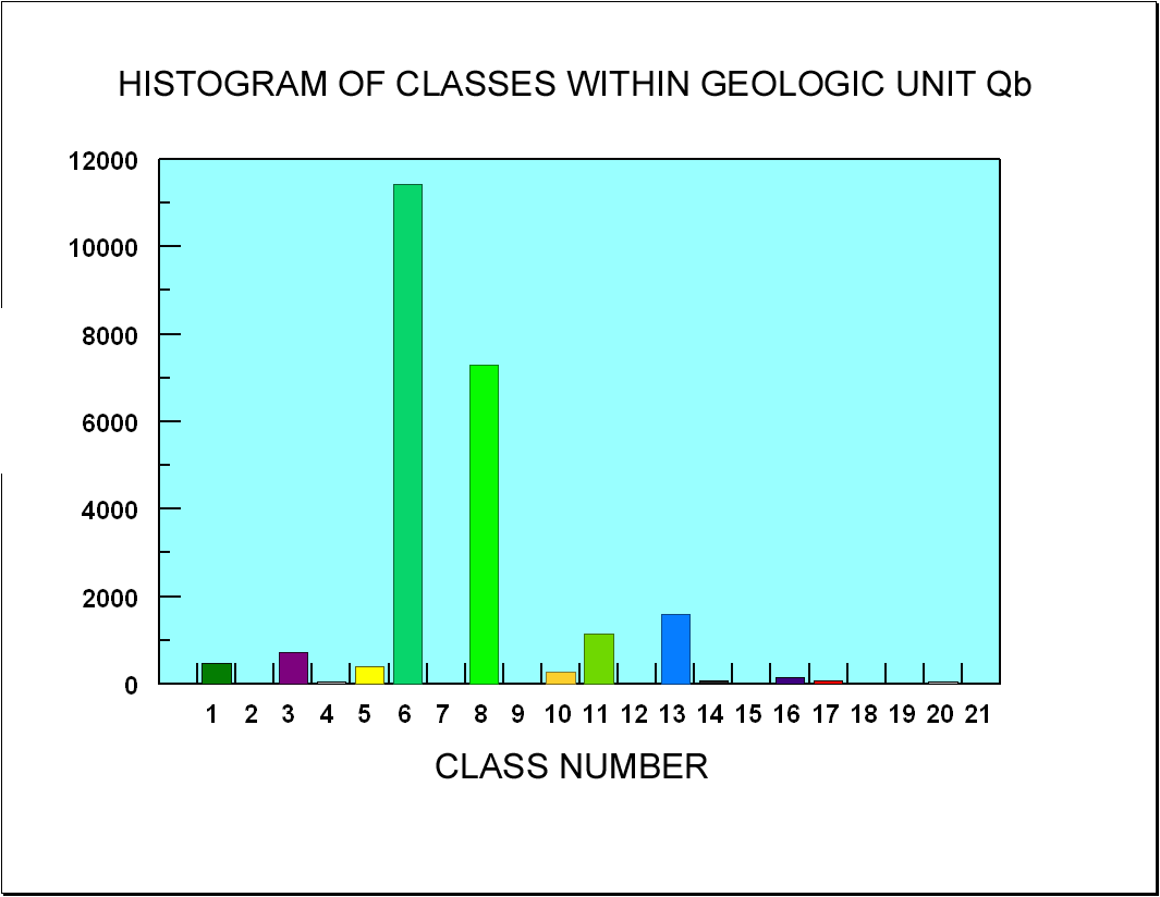
Figure C8. Graph of histogram of the number of grid cells within geologic unit Qb assigned to the various classes.
[Qas] [Qam] [Qds] [Qb] [Qbf] [Qbm] [Ql] [Tg] [Summary]
[Qas] [Qam] [Qds] [Qb] [Qbf] [Qbm] [Ql] [Tg] [Summary]
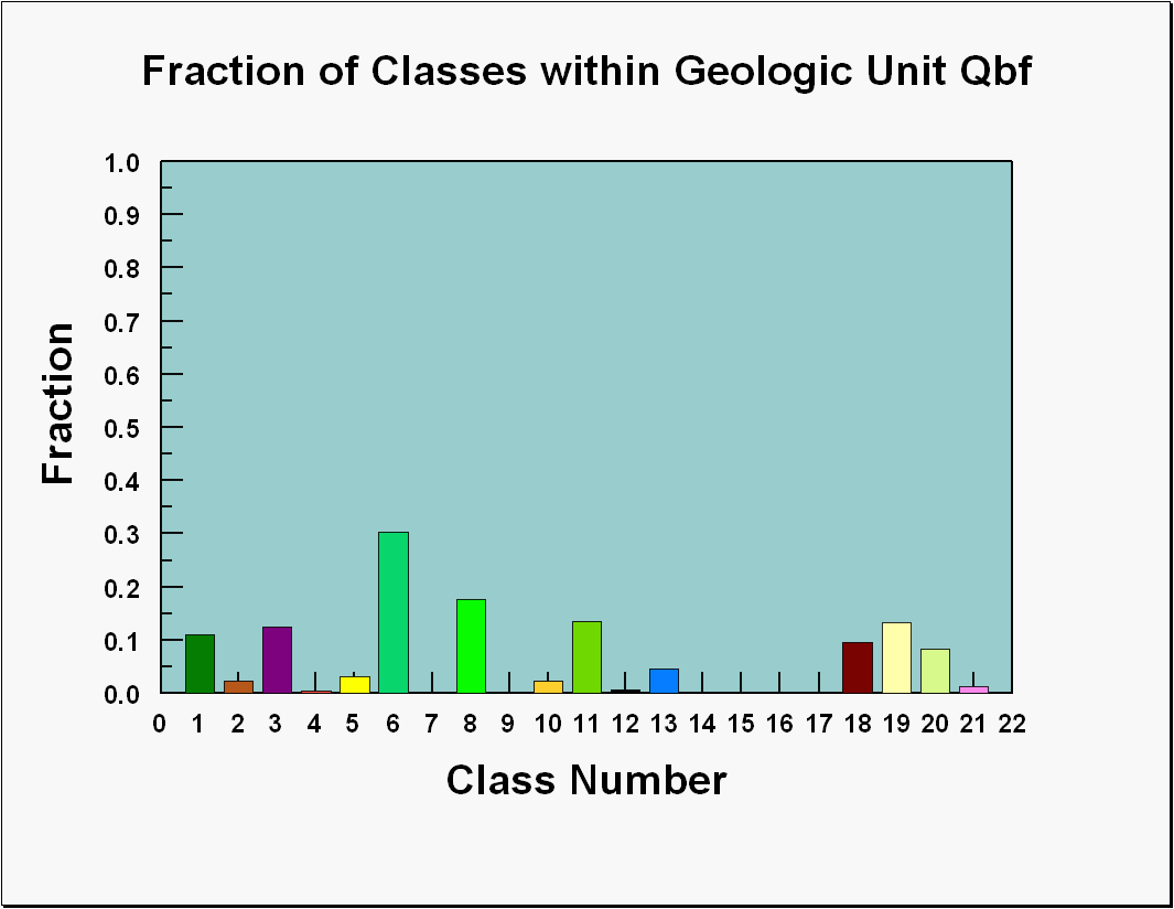
Figure C10 shows the graph of the numbers of grid cells of each class within the areas mapped as floodplain deposits of the Beaumont Formation (Qbf), The classes most frequently associated with this geologic unit are R06 and R08. Classes R01 and R11 also have more than 4,000 grid cells within the areas mapped as Qbf. Figure C11 shows the data presented as the fraction of each class that occurs within the areas mapped as Qbf and more than 17 percent of classes R06 and R08 occur in those areas.
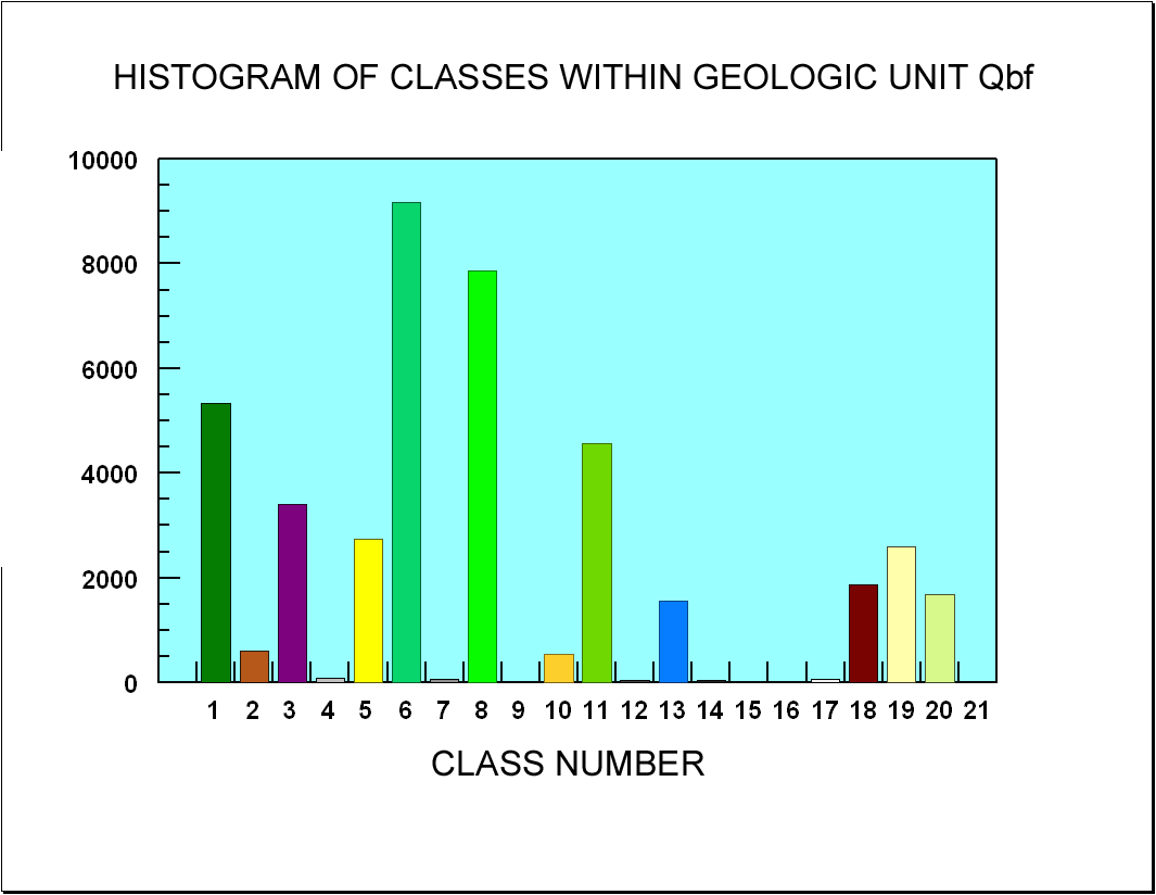
Figure C10. Graph of histogram of the number of grid cells within geologic unit Qbf assigned to the various classes.
[Qas] [Qam] [Qds] [Qb] [Qbf] [Qbm] [Ql] [Tg] [Summary]
[Qas] [Qam] [Qds] [Qb] [Qbf] [Qbm] [Ql] [Tg] [Summary]
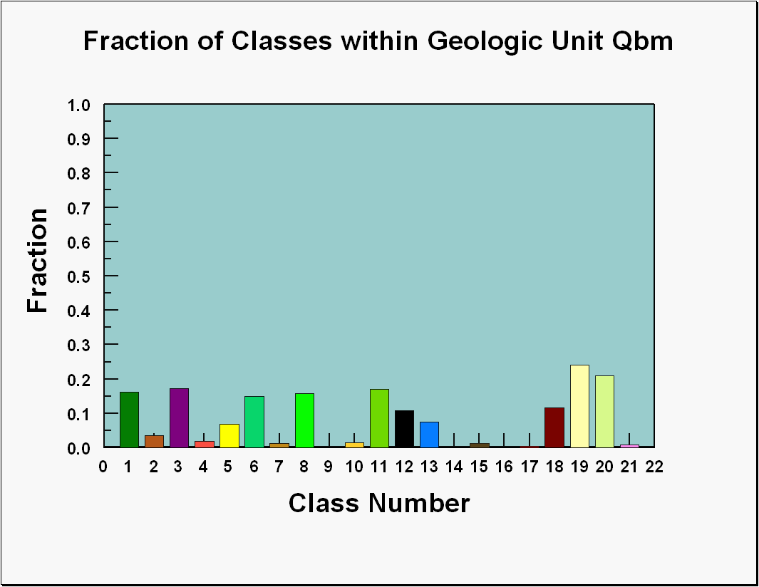
Figure C12 shows the graph of the numbers of grid cells of each class within the areas mapped as mud and clay deposits of the Beaumont Formation (Qbm), The classes most frequently associated with this geologic unit are R01 and R08. Each of classes R03, R05, R06, R11, and R19 also have more than 4,000 grid cells within the areas mapped as Qbm. Figure C13 shows the data presented as the fraction of each class that occurs within the areas mapped as Qbm. Only classes R19 and R20 have more than 20 percent of the class within the areas mapped as Qbm although classes R01, R03, R06, R08, and R11 have more than 14 percent within those areas.
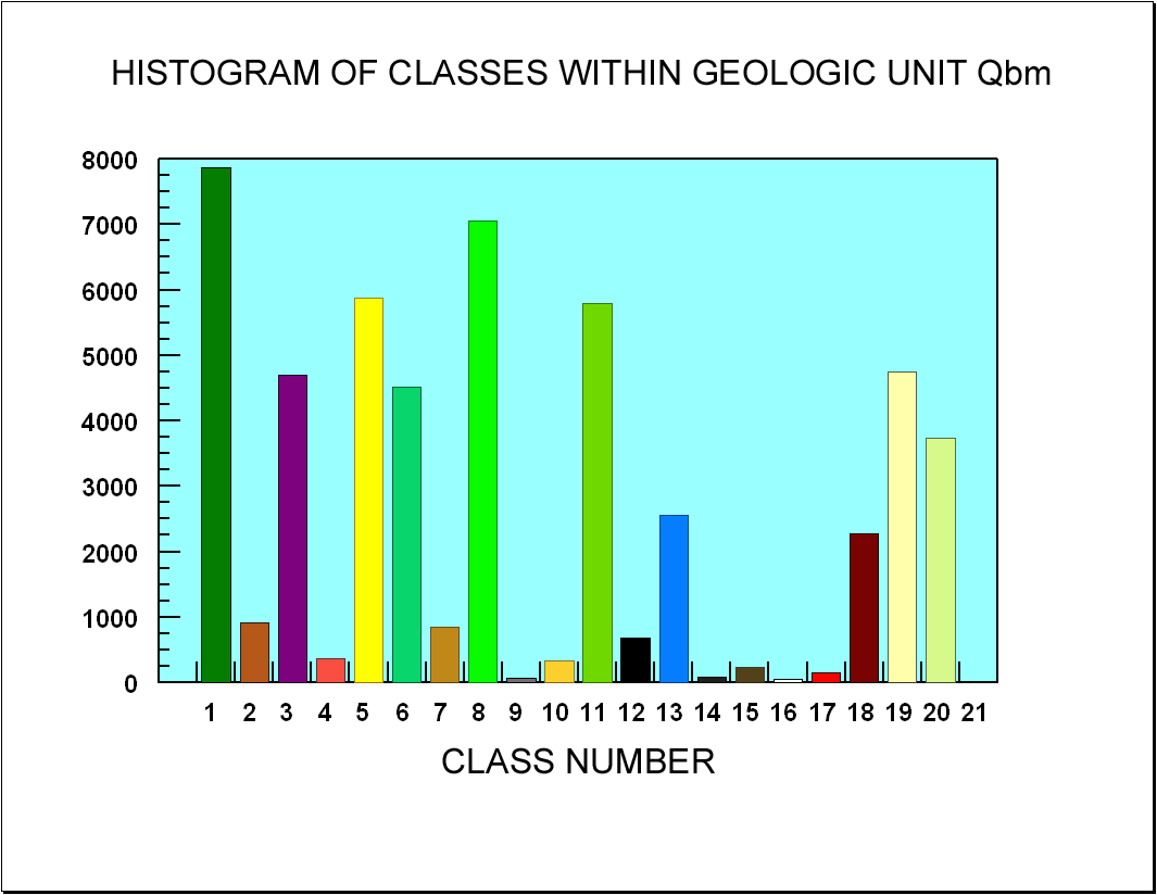
Figure C12. Graph of histogram of the number of grid cells within geologic unit Qbm assigned to the various classes.
[Qas] [Qam] [Qds] [Qb] [Qbf] [Qbm] [Ql] [Tg] [Summary]
[Qas] [Qam] [Qds] [Qb] [Qbf] [Qbm] [Ql] [Tg] [Summary]
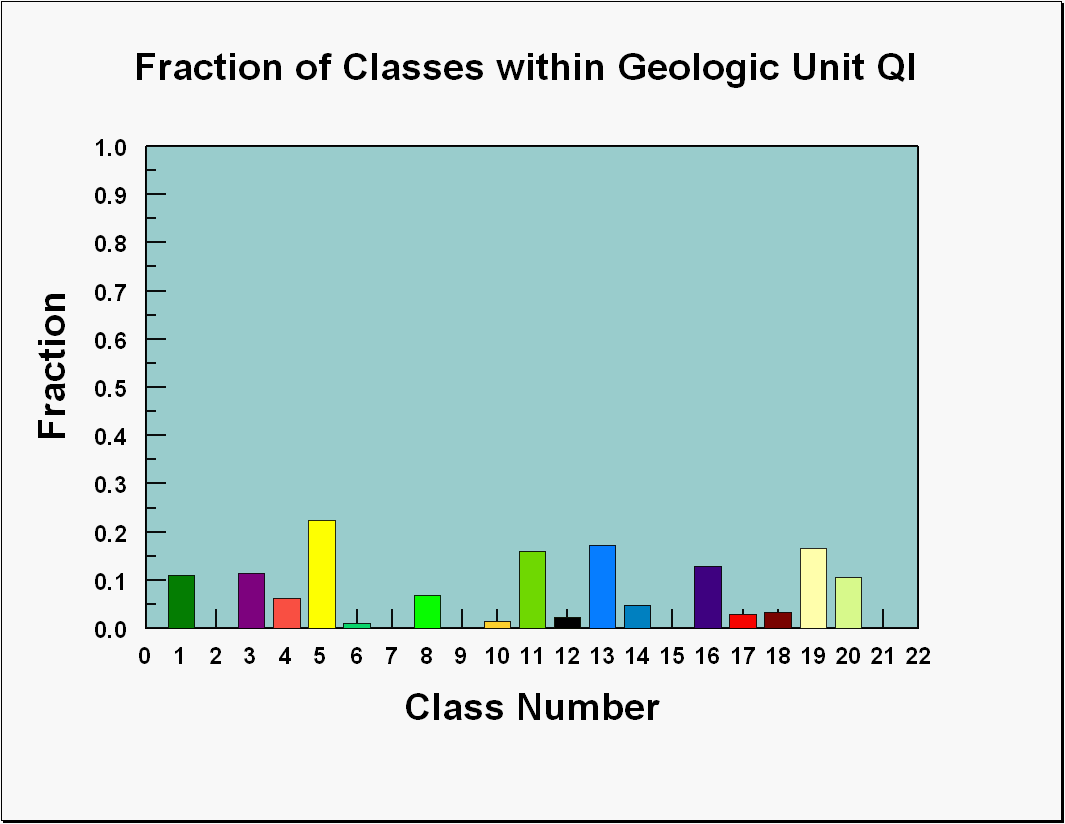
Figure C14 shows the graph of the numbers of grid cells of each class within the areas mapped as Lissie Formation (Ql), The class most frequently associated with this geologic unit is R05. Classes R01, R11 and R13 have more than 5,000 grid cells within the areas mapped as Ql. Figure C15 shows the data presented as the fraction of each class that occurs within the areas mapped as Ql. Only class R05 has more than 20 percent of the class within the areas mapped as Ql although classes R01, R11, and R13 have more than 15 percent within those areas.
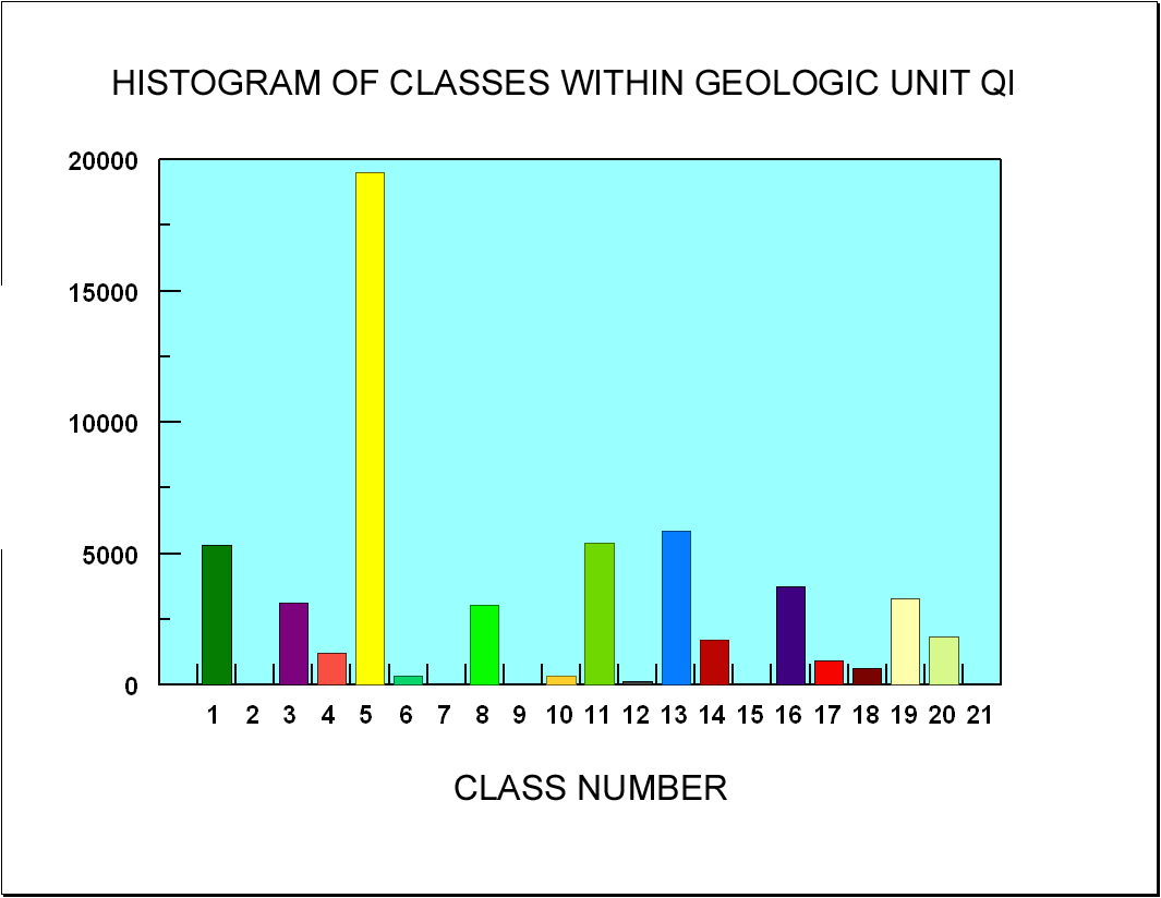
Figure C14. Graph of histogram of the number of grid cells within geologic unit Ql assigned to the various classes.
[Qas] [Qam] [Qds] [Qb] [Qbf] [Qbm] [Ql] [Tg] [Summary]
[Qas] [Qam] [Qds] [Qb] [Qbf] [Qbm] [Ql] [Tg] [Summary]
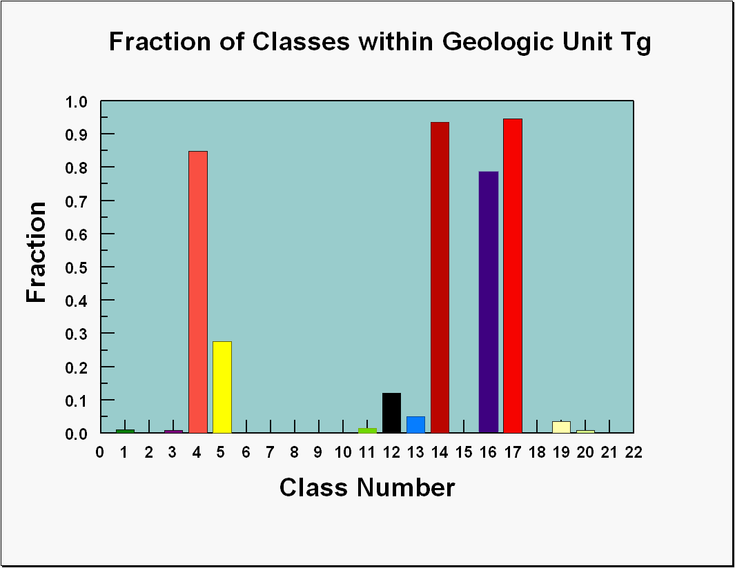
Figure C16 shows the graph of the numbers of grid cells of each class within the areas mapped as undivided Goliad Formation (Tg), The classes most frequently associated with this geologic unit are R14 and R17. Classes R04, R05, and R16 have more than 15,000 grid cells within the areas mapped as Tg. Figure C17 shows the data presented as the fraction of each class that occurs within the areas mapped as Tg and classes R04, R14, R16, and R17 have more than 75 percent of each class within those areas.
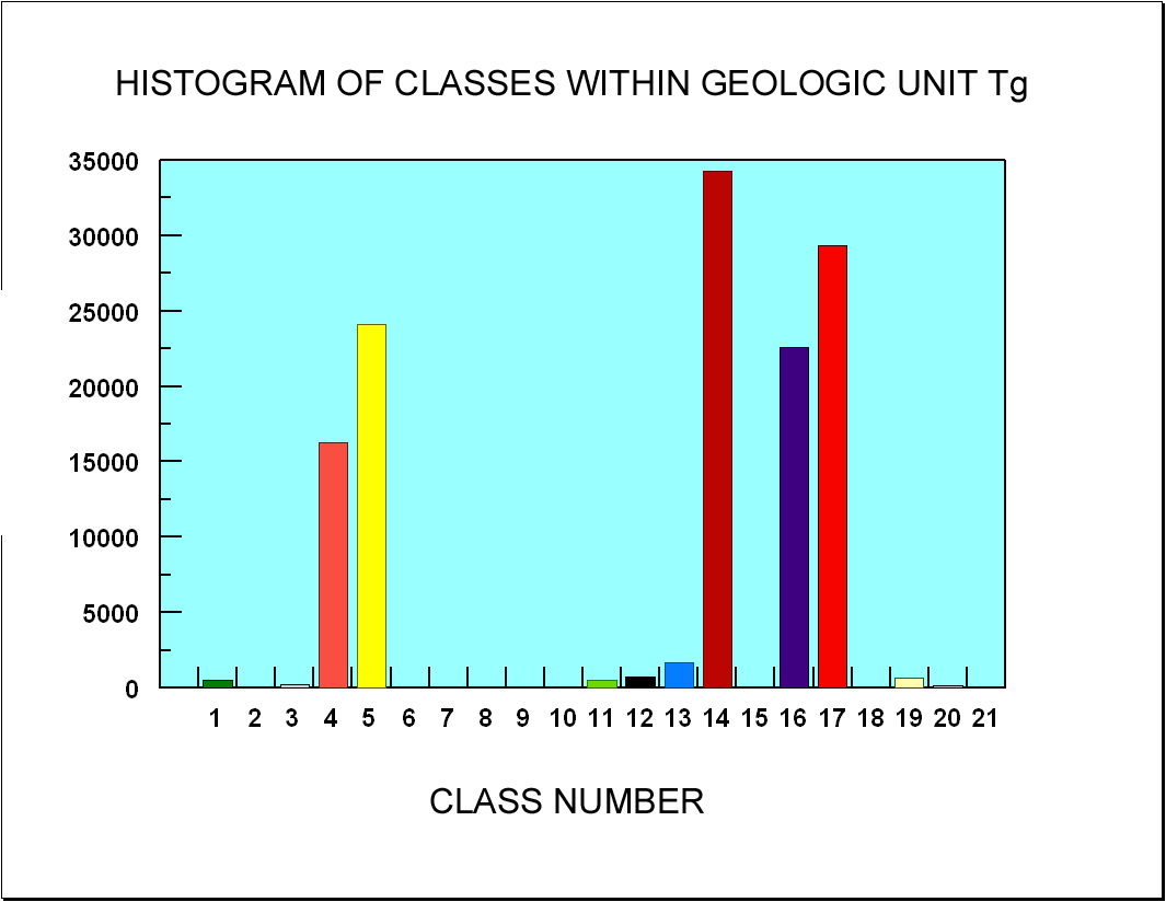
Figure C16. Graph of histogram of the number of grid cells within geologic unit Tg assigned to the various classes.
[Qas] [Qam] [Qds] [Qb] [Qbf] [Qbm] [Ql] [Tg] [Summary]
[Qas] [Qam] [Qds] [Qb] [Qbf] [Qbm] [Ql] [Tg] [Summary]
The histograms of the numbers of grid cells for each class within a mapped geologic unit show that associations of classes with mapped geology are not unique with the exception of the Goliad Formation. Classes R04, R14, R16, and R17 occur almost exclusively within the Goliad Formation and class R12 is clearly a reflection of the presence of lakes or ponds based upon comparison of the classification map to maps showing the locations of lakes and ponds. Table 1 shows the approximate percentages of the classes that occur within the mapped geologic units. The following observations are based upon the table:
About 85 percent of R04, about 94 percent of R14, 79 percent of R16, and 95 percent of R17 occur within areas mapped as units of the Goliad Formation. These relatively high percentages indicate that these classes are robust indicators of the Goliad Formation. One caveat is that some of these classes occur as limited numbers of grid cells around areas classified as R12 which is clearly an indicator of the presence of water. Such grid cells are most likely incorrectly classified as a result of the influence of water on the measurements.
Approximately 83 percent of R06 and 50 percent of R08 occur within areas mapped as members of the Beaumont Formation and reasonably predict the presence of the formation. Classes R01, R03, and R11 most often occur in association with classes R06 and R08 although more than 30 percent of R01, R03, and R11 occur in areas mapped as dune sand deposits (Qds). Comparison of the classification map to the preliminary geologic map shows that large contiguous areas of grid cells classified as R11 coincide with areas mapped as members of the Beaumont Formation.
About 59 percent of R13 and 43 percent of R11 occur within areas mapped as unit Qds and more than 30 percent of classes R01, R03, R05, and R08 occur in areas mapped as Qds.
Areas within unit Qas include 42 percent of R02, 59 percent of R07, 61 percent of R09, 38 percent of R10, 65 percent of R15, and 26 percent of R18. Similarly, areas within unit Qam include 49 percent of R02, 39 percent of R07, 39 percent of R09, 52 percent of R10, 32 percent of R15, and 30 percent of R18. Only minor amounts of these classes occur within other geologic units which indicates that classes R02, R07, R09, R10, R15, and R18 are indicative of the recent floodplain deposits. Neither the sandy unit (Qas) nor the muddy unit (Qam) exhibit a strong separate association with specific classes.
The Lissie Formation does not have a strong candidate for a characteristic class. Some 22 percent of class R05 does occur within the formation and the geographic relationships suggest that it might be an indicator. For that to be true, however, large areas presently mapped as Goliad Formation would have to be mapped as Lissie Formation.
The dune sand deposits (Qds) as represented on the preliminary geologic map include areas of classes R01, R03, R05, R08, R11, R13, R18, R19, and R20. The percentages of the classes ranges from 20 to 59 percent with most of them in the range 20 to 40 percent. Class 13 has 59 percent in areas mapped as Qds. None of the classes exhibit patterns that mimic the patterns of the areas mapped as dune sand deposits (refer to the classification map).
Table 1. This table lists the approximate percentage of each class that occurs within the mapped geologic units.
|
R01 |
R02 |
R03 |
R04 |
R05 |
R06 |
R07 |
R08 |
R09 |
R10 |
R11 |
R12 |
R13 |
R14 |
R15 |
R16 |
R17 |
R18 |
R19 |
R20 |
R21 | |
|
Qam |
13.7% |
42.3% |
7.6% |
0.1% |
1.2% |
7.8% |
58.8% |
7.1% |
61.2% |
37.6% |
2.6% |
28.2% |
1.2% |
0.0% |
65.9% |
0.0% |
0.0% |
25.5% |
8.0% |
15.7% |
33.8% |
|
Qas |
15.0% |
48.8% |
8.4% |
0.3% |
0.9% |
2.5% |
38.9% |
5.0% |
38.5% |
52.4% |
2.7% |
31.1% |
0.9% |
0.0% |
32.3% |
0.1% |
0.0% |
30.0% |
5.3% |
18.2% |
61.9% |
|
Qb |
1.0% |
0.0% |
2.7% |
0.3% |
0.4% |
37.6% |
0.0% |
16.3% |
0.0% |
1.2% |
3.4% |
0.5% |
4.7% |
0.2% |
0.0% |
0.6% |
0.2% |
0.1% |
0.1% |
0.3% |
0.0% |
|
Qbf |
10.9% |
2.2% |
12.4% |
0.4% |
3.2% |
30.2% |
0.1% |
17.5% |
0.0% |
2.2% |
13.5% |
0.6% |
4.6% |
0.1% |
0.1% |
0.0% |
0.2% |
9.5% |
13.2% |
8.3% |
1.2% |
|
Qbm |
16.2% |
3.4% |
17.3% |
1.9% |
6.8% |
14.8% |
1.2% |
15.7% |
0.2% |
1.4% |
17.1% |
10.8% |
7.5% |
0.2% |
1.3% |
0.2% |
0.5% |
11.5% |
24.2% |
20.9% |
0.9% |
|
Qds |
31.1% |
3.1% |
39.2% |
5.7% |
37.4% |
6.0% |
1.0% |
31.5% |
0.1% |
3.8% |
43.2% |
14.4% |
59.0% |
1.2% |
0.4% |
7.6% |
1.6% |
20.2% |
29.1% |
25.3% |
1.9% |
|
Ql |
11.0% |
0.1% |
11.5% |
6.3% |
22.4% |
1.0% |
0.0% |
6.8% |
0.0% |
1.4% |
15.9% |
2.3% |
17.2% |
4.7% |
0.0% |
12.9% |
2.9% |
3.2% |
16.7% |
10.5% |
0.3% |
|
Tg |
1.1% |
0.0% |
0.8% |
84.9% |
27.7% |
0.0% |
0.0% |
0.1% |
0.0% |
0.0% |
1.6% |
12.0% |
5.0% |
93.6% |
0.0% |
78.6% |
94.7% |
0.0% |
3.5% |
0.9% |
0.0% |
![]() Gamma-ray Classification | Statistical Graphs
Gamma-ray Classification | Statistical Graphs ![]()

![]() U.S. Department of the Interior |
U.S. Geological Survey
U.S. Department of the Interior |
U.S. Geological Survey
URL: http://pubsdata.usgs.gov/pubs/of/2005/1231/geologycompare.htm
Page Contact Information: Stephen Snyder
Page Last Modified: Saturday, 12-Jan-2013 21:28:01 EST