USGS Open-File Report 2005-1231
This section discusses a group of classes selected because they appear to be related to Holocene floodplain deposits of the Rio Grande (Qam and Qas). Figure Q1 shows a matrix of potassium histograms comparing classes R02, R07, R09, R15, and R21. Figure Q2 shows a matrix of the uranium histograms and figure Q3 shows a matrix of the thorium histograms.
For class R02, the potassium distribution overlaps the potassium distributions of classes R07 and R15 but has little or no overlap with classes R09, R10, or R21. The uranium distribution of R02 overlaps the uranium distributions of all of the other classes in this group. The thorium distribution of R02 has little or no overlap with the thorium distributions of the other classes in this group. The geographical distribution of R02 (see the classification map) is limited and about 42 percent of the class occurs in areas mapped as muddy floodplain deposits (Qam) and about 49 percent in areas mapped as sandy floodplain deposits (Qas) (see Table 1 of geology comparisons).
For class R07, the potassium distribution overlaps that of class R02, does not overlap that of R10, and exhibits some overlap with the potassium distributions of classes R09, R15, and R21. The uranium distribution of R07 overlaps the uranium distributions of all of the other classes in this group. The thorium distribution of R07 overlaps the thorium distribution of classes R10, R15, and R21, has little overlap with the thorium distribution o fR02, and has some overlap with that of R09. Class R07 is broadly distributed along the floodplain of the Rio Grande (see the classification map) and about 59 percent of the class occurs in areas mapped as muddy floodplain deposits (Qam) and about 39 percent in areas mapped as sandy floodplain deposits (Qas) (see Table 1 of geology comparisons).
For class R09, the potassium distribution overlaps that of class R21, has little overlap with that of R15, and exhibits some overlap with the potassium distributions of classes R02, R07, and R10. The uranium distribution of R09 overlaps the uranium distributions of all of the other classes in this group. The thorium distribution of R09 overlaps the thorium distribution of classes R07, R10, R15, and R21 but does not overlap the thorium distribution of R02. Class R09 is distributed along the floodplain of the Rio Grande (see the classification map) and about 61 percent of the class occurs in areas mapped as muddy floodplain deposits (Qam) and about 39 percent in areas mapped as sandy floodplain deposits (Qas) (see Table 1 of geology comparisons).
For class R10, the potassium distribution overlaps the potassium distributions of classes R09 and R21 but has little overlap with the potassium distributions of the other classes in this group. The uranium distribution of R10 overlaps the uranium distributions of all of the other classes in this group. The thorium distribution of R10 overlaps the thorium distributions of the other classes in this group except class R02 with which there is little overlap. Class R10 is scattered along the floodplain of the Rio Grande (see the classification map) and about 38 percent of the class occurs in areas mapped as muddy floodplain deposits (Qam) and about 52 percent in areas mapped as sandy floodplain deposits (Qas) (see Table 1 of geology comparisons).
For class R15, the potassium distribution overlaps the potassium distributions of class R02, has some overlap with that of R07, but has little or no overlap with the potassium distributions of R09, R10, and R21. The uranium distribution of R15 overlaps the uranium distributions of all of the other classes in this group. The thorium distribution of R15 overlaps the thorium distribution of classes R07, R09, R10, and R21 but has little overlap with the thorium distribution of R02. Class R15 is widely scattered along the floodplain of the Rio Grande (see the classification map) and much of it occurs as small isolated areas that are embedded within areas of class R07. About 66 percent of the class occurs in areas mapped as muddy floodplain deposits (Qam) and about 32 percent in areas mapped as sandy floodplain deposits (Qas) (see Table 1 of geology comparisons).
For class R21, the potassium distribution overlaps the potassium distributions of classes R07, R09, and R10 but has little overlap with the potassium distributions of R02 and R15. The uranium distribution of R21 overlaps the uranium distributions of all of the other classes in this group. The thorium distribution of R21 overlaps the thorium distributions of all of the other classes in this group. Class R21 is distributed along the proximal floodplain of the Rio Grande (see the classification map). About 34 percent of the class occurs in areas mapped as muddy floodplain deposits (Qam) and about 62 percent in areas mapped as sandy floodplain deposits (Qas) (see Table 1 of geology comparisons).
Overall, classes R02, R07, R09, R10, R15, and R21 are robust indicators of Holocene floodplain deposits of the Rio Grande. These classes together account for about 79 percent of the areas mapped as Qam and about 76 percent of the areas mapped as Qas (refer to Table 1 of geology comparisons).
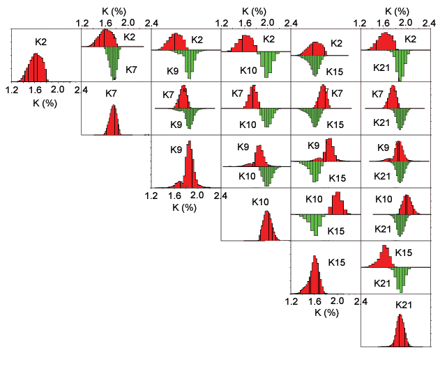
Figure Q1. Matrix of potassium bi-histograms for classes related to Holocene floodplain deposits of the Rio Grande. The number denotes the class (refer to the classification map).
[Figure Q1][Figure Q2][Figure Q3]
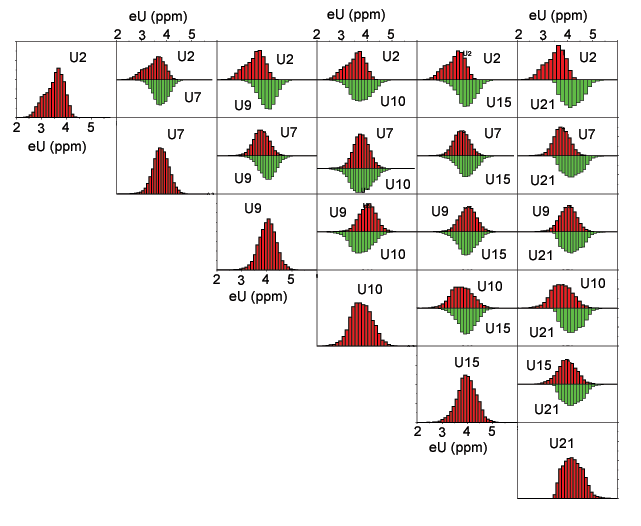
Figure Q2. Matrix of uranium bi-histograms for classes related to Holocene floodplain deposits of the Rio Grande. The number denotes the class (refer to the classification map).
[Figure Q1][Figure Q2][Figure Q3]
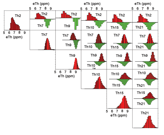
Figure Q3. Matrix of thorium bi-histograms for classes related to Holocene floodplain deposits of the Rio Grande. The number denotes the class (refer to the classification map).
[Figure Q1][Figure Q2][Figure Q3]

![]() U.S. Department of the Interior |
U.S. Geological Survey
U.S. Department of the Interior |
U.S. Geological Survey
URL: http://pubsdata.usgs.gov/pubs/of/2005/1231/riograndegrp.htm
Page Contact Information: Stephen Snyder
Page Last Modified: Saturday, 12-Jan-2013 21:28:28 EST