Link to USGS home page Link to USGS home page
Coastal and Marine Geology Program
Coastal & Marine Geology Program > Coastal Classification Mapping Project > Open File Report 2005-1370

Coastal Classification Atlas

Southeast Texas Coastal Classification Maps - Sabine Pass to the Colorado River

USGS Open File Report 2005-1370

Robert A. Morton, Russell L. Peterson

Report Home Maps Overview Mapping Methods Coastal Classifications Geologic Setting Coastal Processes Coastal Vulnerability Classification Summary References
Introduction || City: Matagorda | Dressing Point | Brown Cedar Cut | Sargent/Brown Cedar Cut | Cedar Lakes West | Cedar Lakes East | Jones Creek/Cedar Lakes East | Freeport | Christmas Point | San Luis Pass | Sea Isle | Lake Como | Galveston | The Jetties | Flake | Caplen | Frozen Point/Caplen | High Island | Mud Lake | Star Lake | Clam Lake | Sabine Pass | Texas Point

Coastal Classification Map Introduction

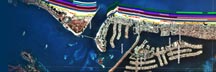
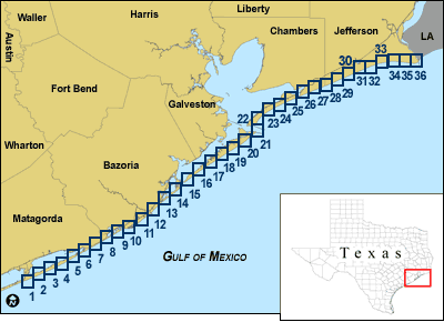
Each map shows an area with the coastal classifications marked as color bars along the shoreline. Below is an example map of Freeport NE/SE. To find out more about how the classification system works, see the Coastal Classifications section. At the bottom of the page is a clickable index map that will take you to the other maps.

Example Coastal Classification map for Freeport NE/SE
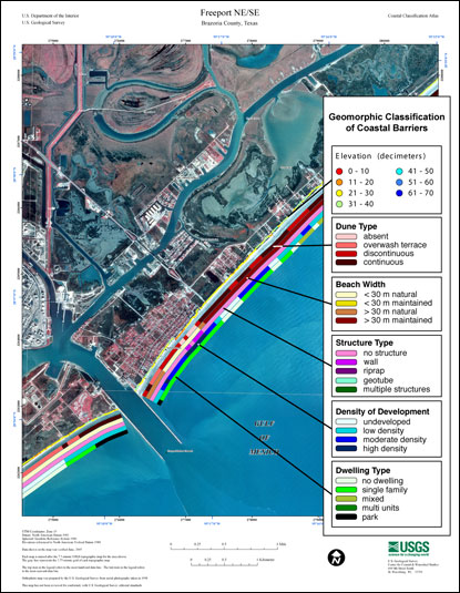
Example Coastal Classification map for Freeport NE/SE.

Index Map for Southeast Texas Coastal Classification Maps - Sabine Pass to the Colorado River
1. Matagorda SW NW
2. Matagorda SE/Matagorda SW NE
3. Dressing Point SW
4. Dressing Point NE/SE
5. Brown Cedar Cut NW
6. Sargent SE/Brown Cedar Cut NE
7. Cedar Lakes West SW
8. Cedar Lakes West NE/SE
9. Cedar Lakes East NW
10. Jones Creek SE/Cedar Lakes East NE
11. Freeport SW
12. Freeport NE/SE
13. Christmas Point SW/Christmas Point OE S NW
14. Christmas Point NE/SE
15. San Luis Pass NW
16. Sea Isle SE
17. Lake Como NW/SW
18. Lake Como NE
19. Galveston SW/Galveston OE S NW
20. Galveston NE/SE
21. The Jetties NW
22. Flake SW
23. Flake NE/SE
24. Caplen NW
25. Frozen Point SE/Caplen NE
26. High Island SW
27. High Island NE/SE
28. Mud Lake NW/SW
29. Mud Lake NE
30. Star Lake SW/South of Star Lake NW
31. Star Lake SE
32. Clam Lake SW
33. Clam Lake NE/SE
34. Sabine Pass NW/SW
35. Sabine Pass NE/SE
36. Texas Point NW/SW
Clickable Index Map. Use the index map above to navigate to the different coastal areas.

Texas Point NW/SouthwestSabine Pass Northeast/SoutheastSabine Pass Northwest/SouthwestClam Lake Northeast/SoutheastClam Lake SouthwestStar Lake SoutheastStar Lake Southwest/South of Star Lake NorthwestMud Lake NortheastMud Lake Northwest/SouthwestHigh Island Northeast/SoutheastHigh Island SouthwestFrozen Point Southeast/Caplen NortheastCaplen NorthwestFlake Northeast/SoutheastFlake SouthwestThe Jetties NorthwestGalveston Northweat/SoutheastGalveston Southwest/Galveston OE South NorthwestLake Como NortheastLake Como Northwest/SouthwestSea Isle SoutheastSan Luis Pass NorthwestChristmas Point Northeast/SoutheastChristmas Point Southwest/Christmas Point OE South NorthwestFreeport Northeast/SoutheastFreeport SouthwestJones Creek Southeast/Cedar Lakes East NortheastCedar Lakes East NorthwestCedar Lakes West Northeast/SoutheastCedar Lakes West SouthwestSargent Southeast/Brown Cedar Cut NortheastBrown Cedar Cut NorthwestDressing Point Northeast/SoutheastDressing Point SouthwestMatagorda Southeast/Matagorda Southwest NortheastMatagorda Southwest NorthwestTexas Point NW/SouthwestSabine Pass Northeast/SoutheastSabine Pass Northwest/SouthwestClam Lake Northeast/SoutheastClam Lake SouthwestStar Lake SoutheastStar Lake Southwest/South of Star Lake NorthwestMud Lake NortheastMud Lake Northwest/SouthwestHigh Island Northeast/SoutheastHigh Island SouthwestFrozen Point Southeast/Caplen NortheastCaplen NorthwestFlake Northeast/SoutheastFlake SouthwestThe Jetties NorthwestGalveston Northweat/SoutheastGalveston Southwest/Galveston OE South NorthwestLake Como NortheastLake Como Northwest/SouthwestSea Isle SoutheastSan Luis Pass NorthwestChristmas Point Northeast/SoutheastChristmas Point Southwest/Christmas Point OE South NorthwestFreeport Northeast/SoutheastFreeport SouthwestJones Creek Southeast/Cedar Lakes East NortheastCedar Lakes East NorthwestCedar Lakes West Northeast/SoutheastCedar Lakes West SouthwestSargent Southeast/Brown Cedar Cut NortheastBrown Cedar Cut NorthwestDressing Point Northeast/SoutheastDressing Point SouthwestMatagorda Southeast/Matagorda Southwest NortheastMatagorda Southwest Northwest

Coastal & Marine Geology Program > Coastal Classification Mapping Project > Open File Report 2005-1370


[an error occurred while processing this directive]