Western Coastal and Marine Geology
U.S. Geological Survey
Open-file Report 2006-1177
Benthic Habitat and Geologic Mapping of the outer Continental Shelf of North-Central California | |||||||||||||||||||||||||||||||||||||
RESULTSSeafloor FeaturesSide-scanning sonar imaging and underwater video (fig. 5) show that Fanny Shoal is underlain by resistant layers of faulted and folded sedimentary rock in an unconformable contact with what appears to be massive granitic rock (fig. 6). The sedimentary rock may be part of the Paleocene Point Reyes Conglomerate (Galloway, 1977), or Miocene and younger formations such as the Santa Margarita Sandstone, Monterey Formation, Santa Cruz mudstone, or Purisima Formation (Clark and others, 1984), all of which are exposed at Point Reyes. At least several hundred meters of section is exposed, suggesting that the sedimentary rocks underlying Fanny Shoal are probably either the Monterey Formation or the Santa Cruz Mudstone, two of the thicker units that comprise most of the Tertiary section in the region. The granitic rock is probably of Mesozoic age and similar to that exposed at Point Reyes and about 10 km to the southeast on the Farallon Islands. Unconsolidated sand, silt, and mud covers the low areas of the shelf surrounding the shoals. The exposed bedrock high that comprises Fanny Shoal appears to be an uplifted block, or horst, between two northwest-trending faults (fig. 6). Several other, probably smaller, faults cross the survey area, mostly trending northwest. The age and sense of offset is unknown but most of the faults appear to be strike-slip faults that have steep or vertical dips and are roughly parallel to onshore traces of faults associated with the San Andreas Fault system.
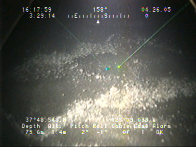
Figure 5. Video observation points (shown in blue) for images 1 - 14 from video observation track lines (shown in red) for the Gulf of Farallones National Marine Sanctuary. To view a large version of Figure 5 in a new window, click on the image above.
Figure 6. Geologic Units and fault lines for Fanny Shoal, outer Continental Shelf of North-Central California. To view a large version of Figure 6 in a new window, click on the image above.
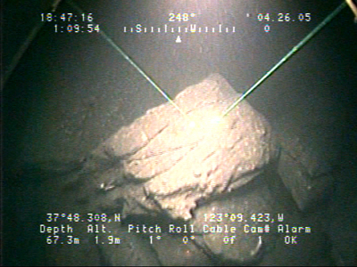
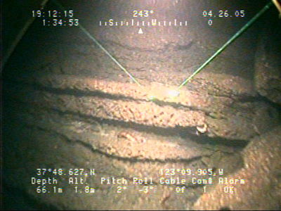
Much of Fanny Shoal is composed of sedimentary rock (Miocene). The bedding trend is variable but is generally northwesterly and the beds appear to have moderate to steep dips ranging to near vertical in some places (Image 1). Underwater video imaging shows high relief of the sedimentary outcrops alternating with less resistant intervals of thin-bedded rock (Image 2). Overhanging ledges and vertical and sub-vertical ledges serve as excellent rockfish habitats with vertical relief is up to 20 meters (Image 3 & 4). We are unable to ascertain the composition of the sedimentary rock due to overgrowth by organisms. In the few places bare rock was clearly visible on underwater video, the rock appeared uniform and fine-grained. Biologic boring on many of the exposed surfaces indicates the rock is not a particularly hard rock type such as chert (Image 5). Rock samples would be necessary for positive identification of any rocks in the survey area.
Image 1. Sedimentary rock outcrop showing cross-bedding. To view a large version of Image 1 in a new window, click on the image above.
Image 2 . Well-exposed bedding planes of varying thickness exhibit the results of differential erosion on the outcrop. To view a large version of Image 2 in a new window, click on the image above.
Image 3. Matridian attached to an outcrop. To view a large version of Image 3 in a new window, click on the image above.
Image 4. A view from above the rock outcrop showing vertical relief of about 2.5 m from the bright rock in foreground to the dark depths in the background of the image. To view a large version of Image 4 in a new window, click on the image above.
Image 5. Boring. Erosional character of part of the sedimentary rock unit. To view a large version of Image 5 in a new window, click on the image above.
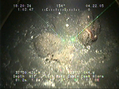
The granitic rock outcrops trend northwest-southeast with a large mass in the central area of the shoal where a ridge-like exposure extends to the northwest from the main exposure. The rock interpreted to be granite appears to be massive and has no indication of bedding as determined from both side-scanning sonar and camera observations. Several prominent joint sets are apparent. Fragments of the granitic rock tend to be more angular in appearance and vary greatly in size. The granitic rock outcrops have high relief and often form low areas where fracturing is more intense (Image 6).
Image 6. Rounded and sub-rounded boulders and cobbles. To view a large version of Image 6 in a new window, click on the image above.
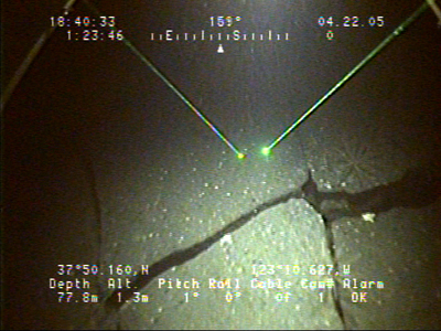
The sediment texture increases in both grain size and in the variability of bed forms with increasing proximity to Fanny Shoal. In the area adjacent to the rock outcrop of Fanny Shoal the sediment is medium to coarse-grained sand that becomes progressively coarser, to pebbles and cobbles (images show progression toward from fine grained sand to rocky outcrop: Images 7, 8, 9, & 10).
Image 7. Fine grained rippled sand, with brittle star appendages protruding from the sediment surface. To view a large version of Image 7 in a new window, click on the image above.
Image 8. Approaching an outcrop, Sea Cucumber on a small boulder surrounded with fine sand and shell debris. To view a large version of Image 8 in a new window, click on the image above.
Image 9. Sub-angular and rounded cobbles and boulders. To view a large version of Image 9 in a new window, click on the image above.
Image 10. Exposure of fractured massive rock. To view a large version of 10 in a new window, click on the image above.
The outer edges of the shoal contain linear bands of coarse-grained sediment consisting of sand, silt, and shell debris overlying or in contact with bioturbated fine-grained sand, silt, and mud as observed in underwater camera transects (Image 11). The linear bands of coarser sediment are oriented oblique to the shoals and become wider in size nearer to the shoal. At least two major types of sand wave deposits occur in the study area. Deposits with a general northeasterly trend occur in large oblong patches roughly 20-40 meters wide and about 150 meters long, ranging up to irregular patches up to 2 km across (Image 12). Another set of sand waves has a general northwesterly trend and are smaller, typically less than 5 meters wide and ranging from about 30 to several hundred meters long (Image 13). In places, these two sets of sand waves intersect and coalesce. We speculate that the northeasterly-trending deposits are caused by along shore currents (image 14). North of the shoal is a large area of rippled mud, silt, and fine sand with few scattered areas of sand waves. The low area on the southwest side of the shoal is covered by areas of rippled fine silt and finer mud alternating with areas of sand waves comprised of sand, silt, and shell debris. The edges of the bedrock outcrops of the shoal are mantled by a debris apron of hummocky deposits of sand, pebbles, and cobbles.
Image 11. Shell fragments with pebbles and cobbles. To view a large version of Image 11 in a new window, click on the image above.
Image 12. Coarse grained sand waves with shell debris in the trough. To view a large version of 04-521 in a new window, click on the image above.
Image 13. Straight-crested sand waves with shell fragments in the troughs. To view a large version of Image 13 in a new window, click on the image above.
Images 14 . Mega ripples in sand. Flat fish in the foreground. To view a large version of Image 14 in a new window, click on the image above.
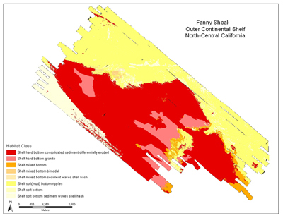
Habitat ClassificationThe diverse bottom characteristics of the Fanny Shoal area, which include factors such as bottom type, hardness, sediment texture, bedforms, and morphology, allow the classification of 8 benthic habitat types, shown in Figure 4. A translation of benthic habitat codes used in this study is shown in Table 1, following the methodology of Greene (and others, 1999). The shoals comprise a rugged, rocky bottom that rises up to 50 meters above the surrounding marine shelf and includes a variety of habitats. The shoals are underlain mainly by granitic and sedimentary rock that form a variety of rocky ridges, pinnacles, cracks, and overhangs (Sh_g and Shd_c_d), but also include numerous, scattered areas of mixed cobbles, boulders, sand, and mud (Sm). A debris apron typically lies adjacent to the rocky outcrops, consisting of mixed cobble, boulders, sand, and mud (Sm_b). These debris aprons seem best developed on the southeast sides of the rocky areas, sometimes forming large patches covering several hundred square meters. Surrounding the shoals are primarily soft-bottom habitats that include large areas of variously bioturbated, fine sandy to silty mud (Ss), often showing rippled surfaces (Ss(m)_r). Interspersed with these muddy areas are hummocky areas of sandwaves comprised of fine sand and shell debris (Ssw_sh). The sandwaves occur in long bands with at least two favored orientations northeast of the shoals, whereas on the southwest side the sandwaves occur in larger, less linear patches, between areas of rippled sandy and silty mud.
Figure 7. Habitat classifiacation map of Fanny Shoal, outer continental shelf of north-central California. To view a large version of Figure 7 in a new window, click on the image above.
Table 1. Definition of benthic habitat codes in Fanny Shoal, outer continental shelf of north-central California. Classification follows Greene and others (1999).
|
Introduction Methods Results |
||||||||||||||||||||||||||||||||||||
|
|||||||||||||||||||||||||||||||||||||
Accessibility
|
FOIA
| Privacy
|
Policies and Notices
U.S. Department of the Interior
U.S. Geological Survey
URL: http://walrus.wr.usgs.gov/
maintained by Michael Diggles
last modified October 2, 2006 (mfd)