Skip past header information

U.S. Geological Survey Open-File Report 2006-1195

Surficial sediment character of the Louisiana offshore continental shelf region: A GIS Compilation

Transects  
Home
Introduction
Nomenclature
Coastal Change
Data Dictionary
Browse Maps
References
Related Web Sites
For Educators
Acknowledgments
Contacts
Disclaimer
README
 

Transect 1 (pdf)

Transect 2 (pdf)


Transects:

Transect 1 perpendicular to Ship Shoal

Image displays  North-south transect along western Ship Shoal, sediment composition along western Ship Shoal transect usSEABED values of sorting and mean grain size along western Ship Shoal transect SS1


Transect 2 perpendicular to Ship Shoal

Image displays  North-south transect along eastern Ship Shoal,  sediment composition along eastern Ship Shoal transect SS2, wusSEABED values of sorting and mean grain size along eastern Ship Shoal transect SS2.

Adobe Reader To view files in format, download free copy of Adobe Reader.


skip index

Main Menus
OFR 2006-1195 Home | Introduction | Nomenclature | Coastal Change | Data Dictionary | Data Catalog | Browse Maps | References | Related Web Sites | For Educators | Acknowledgments | Contacts | Disclaimer| README


Sub-Menus
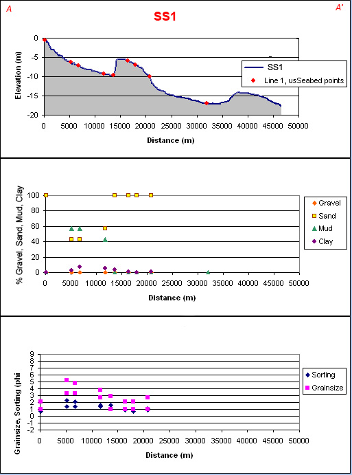
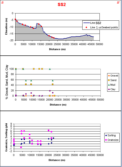
Transect 1 | Transect 2 |


Skip past footer information

U.S. Department of Interior
> U.S. Geological Survey > Coastal and Marine Geology Program > Woods Hole Science Center

Disclaimer and Accessibility

Accessibility FOIA Privacy Policies and Notices

Take Pride in America home page. FirstGov button U.S. Department of the Interior | U.S. Geological Survey
URL: http://pubsdata.usgs.gov/pubs/of/2006/1195/htmldocs/transects.htm
Page Contact Information: Publishing Services
Page Last Modified: Saturday, 12-Jan-2013 22:32:42 EST