
Open-File Report 2007-1150
Sidescan-Sonar Imagery, Multibeam Bathymetry, and Surficial Geologic Interpretations of the Sea Floor in Rhode Island Sound, off Sakonnet Point, Rhode Island
![]() Title |
Introduction |
Geologic Setting |
Data Acquisition/Processing |
Bathymetry |
Sidescan-Sonar Imagery |
Environments |
Discussion |
Summary |
GIS Data Catalog |
Acknowledgments |
References |
Figures |
Contacts
Title |
Introduction |
Geologic Setting |
Data Acquisition/Processing |
Bathymetry |
Sidescan-Sonar Imagery |
Environments |
Discussion |
Summary |
GIS Data Catalog |
Acknowledgments |
References |
Figures |
Contacts
 |
||
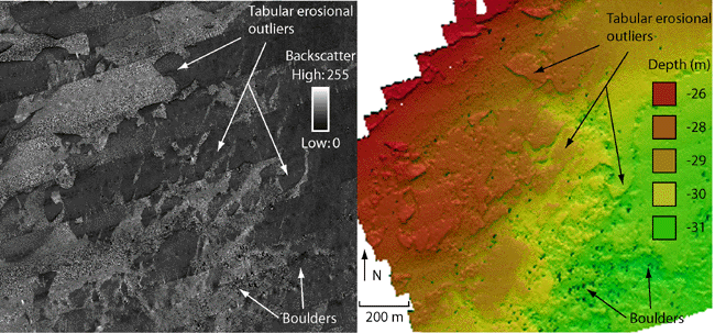
Figure 14. Detailed view of sidescan-sonar imagery and corresponding hill-shaded bathymetry showing tabular erosional outliers. Curvilinear shadows in the sidescan-sonar imagery correspond to the outline of small plateaus in the bathymetry. Boulders are visible in both images, on the sidescan-sonar imagery as light-toned targets with dark shadows and within the bathymetry as dark targets. The area of boulders in the lower right corner of both images shows an exposure of till. Lighter backscatter between the erosional outliers is from coarse-grained, bouldery sediment. Images are in UTM. Location of figure shown in figure 2 . | ||

![]() U.S. Department of the Interior |
U.S. Geological Survey
U.S. Department of the Interior |
U.S. Geological Survey
URL: http://pubsdata.usgs.gov/pubs/of/2007/1150/html/fig14.html
Page Contact Information: GS Pubs Web Contact
Page Last Modified: Friday, 24-Jan-2025 12:55:40 EST

