
Open-File Report 2007-1150
Sidescan-Sonar Imagery, Multibeam Bathymetry, and Surficial Geologic Interpretations of the Sea Floor in Rhode Island Sound, off Sakonnet Point, Rhode Island
![]() Title |
Introduction |
Geologic Setting |
Data Acquisition/Processing |
Bathymetry |
Sidescan-Sonar Imagery |
Environments |
Discussion |
Summary |
GIS Data Catalog |
Acknowledgments |
References |
Figures |
Contacts
Title |
Introduction |
Geologic Setting |
Data Acquisition/Processing |
Bathymetry |
Sidescan-Sonar Imagery |
Environments |
Discussion |
Summary |
GIS Data Catalog |
Acknowledgments |
References |
Figures |
Contacts
 |
||
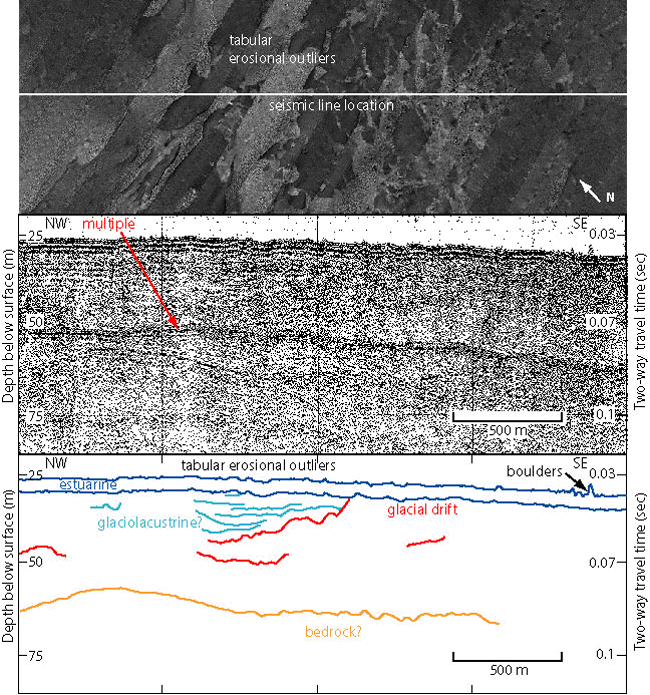
Figure 15. Sidescan-sonar imagery, Boomer seismic-reflection profile (O'Hara and Oldale, 1980), and interpretation through an area of tabular erosional outliers. Top image shows location of the seismic profile on the sidescan-sonar data and erosional outliers in the center. Lower images of seismic profile and interpretation show stratified sediments, possibly from a small glacial lake or pond, below the erosional outliers. Note irregular sea floor and estuarine sediments above laminations, likely due to prior erosion of lacustrine sediments. Boulders can be seen rising above the sea floor. Vertical exaggeration: 16X. Depths are based on the assumed compressional wave velocity of 1500 m/s. Figure location is shown in figure 2. | ||

![]() U.S. Department of the Interior |
U.S. Geological Survey
U.S. Department of the Interior |
U.S. Geological Survey
URL: http://pubsdata.usgs.gov/pubs/of/2007/1150/html/fig15.html
Page Contact Information: GS Pubs Web Contact
Page Last Modified: Friday, 24-Jan-2025 12:55:54 EST

