U.S. Geological Survey OFR 2007-1397
2ETI, St. Petersburg, FL 33701.
Page Content: |
||||
 |
||||
Click once to open image in new window or tab, then click on opened image to zoom in.
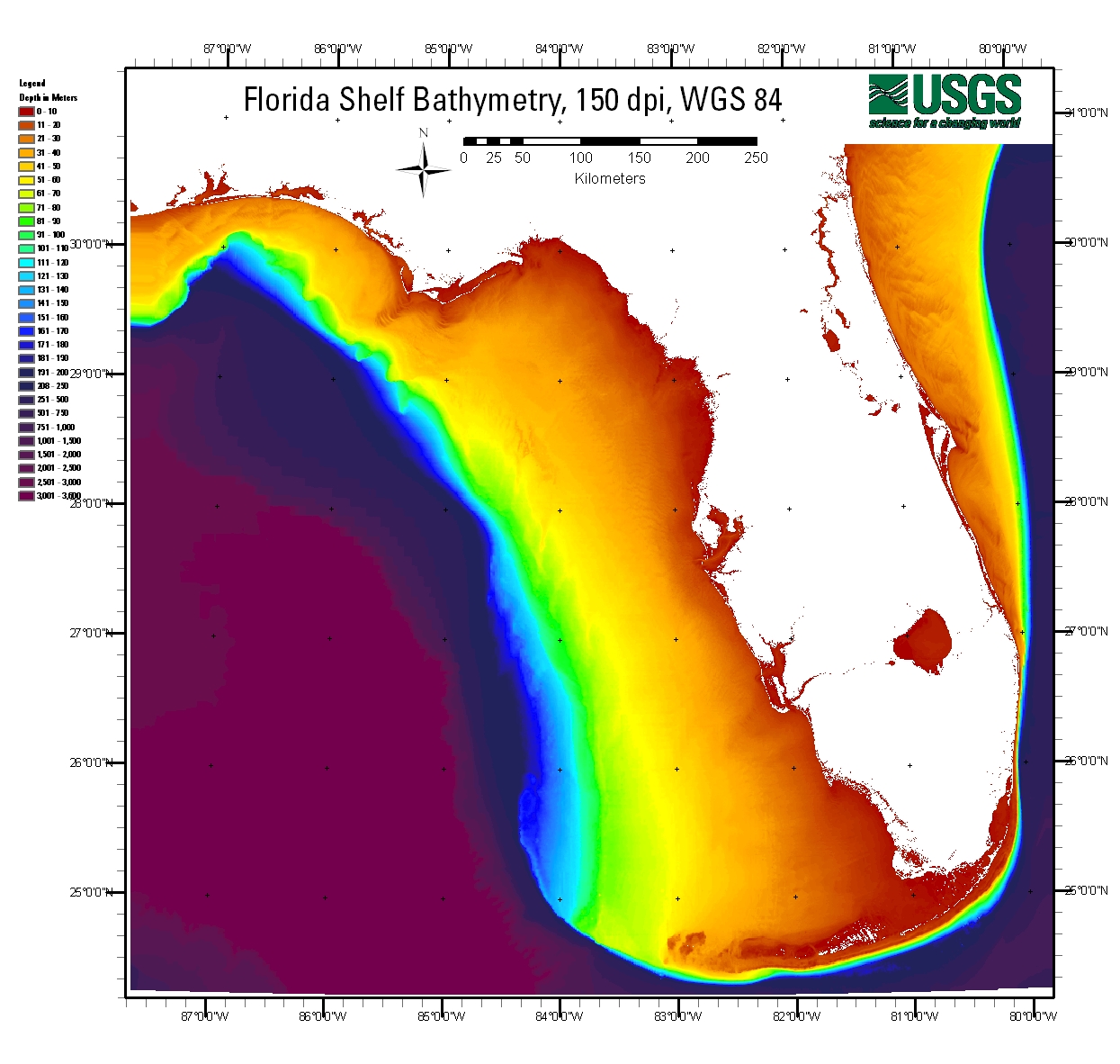
The Florida shelf represents a finite source of economic resources, including commercial and recreational fisheries, tourism, recreation, sand and gravel resources, phosphate, and freshwater reserves. Yet the basic information needed to locate resources, or to interpret and utilize existing data, comes from many sources, dates, and formats. A multi-agency effort is underway to coordinate and prioritize the compilation of suitable datasets for an integrated information system of Floridas coastal and ocean resources. This report and the associated data files represent part of the effort to make data accessible and useable with computer-mapping systems, web-based technologies, and user-friendly visualization tools. Among the datasets compiled and developed are seafloor imagery, marine sediment data, and existing bathymetric data. A U.S. Geological Survey-sponsored workshop in January 2007 resulted in the establishment of mapping priorities for the state. Bathymetry was identified as a common priority among agencies and researchers. State-of-the-art computer-mapping techniques and data-processing tools were used to develop shelf-wide raster and vector data layers. Florida Shelf Habitat (FLaSH) Mapping Project (http://coastal.er.usgs.gov/flash) endeavors to locate available data, identify data gaps, synthesize existing information, and expand our understanding of geologic processes in our dynamic coastal and marine systems.
The Disc Contents page is a diagram of the location of all files and folders contained on this disc and provides links to these files and folders.
To access the information contained on this disc, use a Web browser to open the file index.html. This report is divided into four sections: Report, Data, Metadata, and Software. Links at the top and bottom of each page provide access to these sections. This report contains links to the USGS and collaborators or other resources that are only accessible if access to the Internet is available while viewing these documents. Note: The only supported Web browsers that properly display all features of the interactive profiles are Internet Explorer 6 for Windows and Firefox 1.5 for all platforms
This DVD publication was prepared by an agency of the United States Government. Neither the United States Government nor any agency thereof nor any of their employees makes any warranty, expressed or implied, or assumes any legal liability or responsibility for the accuracy, completeness, or usefulness of any information, apparatus, product, or process disclosed in this report or represents that its use would not infringe privately owned rights. Reference therein to any specific commercial product, process, or service by trade name, trademark, manufacturer, or otherwise does not constitute or imply its endorsement, recommendation, or favoring by the United States Government or any agency thereof.
Although all data and software published on this disc have been used by the USGS, no warranty, expressed or implied, is made by the USGS as to the accuracy of the data and related materials and (or) the functioning of the software. The act of distribution shall not constitute any such warranty, and no responsibility is assumed by the USGS in the use of these data, software, or related materials.
This disc is readable on any computing platform that has standard DVD driver software installed. The minimum software requirements are a Web browser, Adobe Reader, and a text editor. If you cannot fully access the information on this page, please contact USGS Information Services at infoservices@usgs.gov or 1-888-ASK-USGS. Note: The only supported Web browsers that properly display all features of the interactive profiles are Internet Explorer 6 for Windows and Firefox 1.5 for all platforms.
For further information about this project, contact Paul Knorr at USGS, St. Petersburg, FL.
U.S. Department of the Interior
U.S. Geological Survey
Florida Integrated Science Center - St. Petersburg
Publications are available from USGS Information Services, Box 25286, Federal Center, Denver, CO 80225-0046 (telephone 1-888-ASK-USGS; e-mail: infoservices@usgs.gov).
Funding for this study was provided by the USGS Coastal and Marine Geology Program.

![]() U.S. Department of the Interior |
U.S. Geological Survey
U.S. Department of the Interior |
U.S. Geological Survey
URL: https://pubsdata.usgs.gov/pubs/of/2007/1397/index.html
Page Contact Information: Publishing Service Center
Page Last Modified: Wednesday, 07-Dec-2016 20:59:21 EST