U.S. Geological Survey Open-File Report 2008-1206
Coastal Change Along the Shore of Northeastern South Carolina: The South Carolina Coastal Erosion Study
Return to: Title and Abstract » Table of Contents » Section 1 » Section 2 » Section 3 » Section 4 » Section 5 » Section 6 » Acknowledgments » References » List of Figures » Acronymns » Glossary |
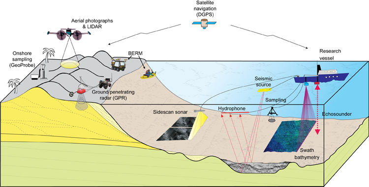
Figure 2.1. Schematic diagram showing the different techniques used to investigate the active beach system along the Grand Strand. Acoustic instruments (sidescan sonar, swath bathymetry and subbottom profilers) provide information on the distribution of sediments, topography, and underlying structure of the shallow seafloor adjacent to the beach. On land, ground-penetrating radar (GPR) determines the thickness and structure of sediment beneath the beach and dunes. Sediment grain size, composition, and age are determined by direct sampling of offshore and onshore deposits. To monitor short-term changes in beach morphology, precise elevation measurements are collected from the dune to the edge of the inner shelf by using all-terrain vehicles on land and small boats offshore as part of the Beach Erosion Research and Monitoring (BERM) program. Aerial photography and Light Detection and Ranging (LIDAR) are used to survey and quantify changes along the coast. Differential Global Positioning Systems (DGPSs) are used to locate all data accurately. [Click here for high-resolution image.] |
 |