N80_1PNG.TXT: Grayscale Seismic-Reflection Images in PNG Format from Western Rhode Island Sound

Metadata also available as Outline | Text

Frequently-anticipated questions:


What does this data set describe?

Title:
N80_1PNG.TXT: Grayscale Seismic-Reflection Images in PNG Format from Western Rhode Island Sound
Abstract:
During 1980, a Uniboom seismic-reflection survey was conducted by the U.S. Geological Survey (USGS) in western Rhode Island Sound aboard the Research Vessel NeechoThe cruise consisted of 2 legs and had a total of 8 survey days. Data from this survey were recorded in analog form and archived at the USGS. As a result of recent interest in the geology of Rhode Island Sound and in an effort to make the data more readily accessible while preserving the original paper records, the seismic data from this cruise were scanned and converted to TIFF and PNG images and SEG-Y data files. In order to scan the lines, some of the paper records were cut and scanned in sections. These sections are labeled with lower-case letters and differ from the names of lines in the logbook. Some SEG-Y files were further divided in order for each file to contain continuous data collected at the same ship speed; these line segments have been labeled _1, _2, or _3 after the section label. Navigation data were converted from LORAN-C time delays to latitudes and longitudes that are available in ESRI shapefile format and as eastings and northings in space-delimited text format.
  1. How should this data set be cited?

    U.S. Geological Survey, 2009, N80_1PNG.TXT: Grayscale Seismic-Reflection Images in PNG Format from Western Rhode Island Sound: Open-File Report 2009-1002, U.S. Geological Survey, Coastal and Marine Geology Program, Woods Hole Science Center, Woods Hole, MA.

    Online Links:

    This is part of the following larger work.

    McMullen, K.Y., Poppe, L.J., and Soderberg, N.K., 2009, Digital Seismic-Reflection Data from Western Rhode Island Sound, 1980: Open-File Report 2009-1002, U.S. Geological Survey, Coastal and Marine Geology Program, Woods Hole Science Center, Woods Hole, MA.

    Online Links:

  2. What geographic area does the data set cover?

    West_Bounding_Coordinate: -71.569208
    East_Bounding_Coordinate: -71.130113
    North_Bounding_Coordinate: 41.485329
    South_Bounding_Coordinate: 41.191382

  3. What does it look like?

    <https://pubs.usgs.gov/of/2009/1002/data/seismics/png/n80_1png.gif> (GIF)
    Browse image of seismic-line locations from cruise NECH80-1.

  4. Does the data set describe conditions during a particular time period?

    Beginning_Date: 09-Jul-1980, 19800929
    Ending_Date: 17-Jul-1980, 19801002
    Currentness_Reference: ground condition

  5. What is the general form of this data set?

  6. How does the data set represent geographic features?

    1. How are geographic features stored in the data set?

      This is a Raster data set.

    2. What coordinate system is used to represent geographic features?

  7. How does the data set describe geographic features?


Who produced the data set?

  1. Who are the originators of the data set? (may include formal authors, digital compilers, and editors)

  2. Who also contributed to the data set?

  3. To whom should users address questions about the data?

    Katherine McMullen
    U.S. Geological Survey
    Sediment Lab Technician
    384 Woods Hole Road
    Woods Hole, MA 02543
    USA

    (508) 548-8700 x2277 (voice)
    (508) 457-2310 (FAX)
    kmcmullen@usgs.gov


Why was the data set created?

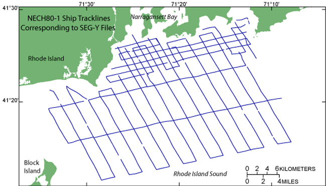
This data set contains grayscale seismic-reflection images in PNG format from the seismic-reflection data set collected aboard the R/V NEECHO during a 1980 geophysical cruise in western Rhode Island Sound. The seismic data provide useful information about the framework geology in this region. This metadata describes the PNG files as a whole.


How was the data set created?

  1. From what previous works were the data drawn?

    Original seismic-reflection profiles (source 1 of 1)

  2. How were the data generated, processed, and modified?

    Date: 1980 (process 1 of 4)
    Original analog seismic records of cruise NECH80-1 were obtained using a towed EG&G Uniboom system with a half-second fire rate. The signal was amplified and filtered to a 400- to 4000-Hz bandpass. The seismic data have 1- to 2-m resolution. Seismic data were printed on EPC recorders at a quarter-second sweep rate.

    Date: 2008 (process 2 of 4)
    Original seismic records were scanned at 300 dpi, 24-bit grayscale on an Ideal Contex Crystal TX 40 scanner using Ideal ScanOS version 2.5.4 software and saved as TIFFs, after being roughly rotated and cropped. Some seismic lines were too long to scan at once and were cut into sections, other lines were collected in sections. These sections are noted in the file names with lower-case letters after the line number. For instance, n80_102Ac.tif signifies the cruise as R/V NEECHO in 1980 (NECH80-1), line 02A, section c, and TIFF format. Capitalized letters are part of the original line number, as recorded in the logbook and on the seismic line.

    Person who carried out this activity:

    Katherine McMullen
    U.S. Geological Survey
    Sediment Lab Technician
    384 Woods Hole Road
    Woods Hole, MA 02543
    USA

    (508) 548-8700 x2277 (voice)
    (508) 457-2310 (FAX)
    kmcmullen@usgs.gov

    Date: 2008 (process 3 of 4)
    TIFFs were then opened in Adobe Photoshop CS2 and saved as 200 dpi grayscale TIFFs.

    Person who carried out this activity:

    Katherine McMullen
    U.S. Geological Survey
    Sediment Lab Technician
    384 Woods Hole Road
    Woods Hole, MA 02543
    USA

    (508) 548-8700 x2277 (voice)
    (508) 457-2310 (FAX)
    kmcmullen@usgs.gov

    Date: 2008 (process 4 of 4)
    Grayscale TIFFs were further processed in Adobe Photoshop CS2 in order to aid in creating the SEG-Y files. These TIFF images were rotated so they were nearly perfectly horizontal and cropped to start and end shots with known positions and saved as PNG files. Seismic-reflection profiles that had noted changes in ship speed or places where recording stopped for belt changes were split into segments, so each file was obtained at roughly the same speed. These segments are labeled with _1, _2, or _3 after the section, thus the file names differ slightly from the line names as used in the logbook. Since PNG images were clipped in the process of making SEG-Y files, users are encouraged to view the TIFF images available in this report (<https://pubs.usgs.gov/of/2009/1002/html/wris_prof.html>) in order to see field notes related to data acquisition and weather conditions, which were written directly on the paper records.

    Person who carried out this activity:

    Katherine McMullen
    U.S. Geological Survey
    Sediment Lab Technician
    384 Woods Hole Road
    Woods Hole, MA 02543
    USA

    (508) 458-8700 x2277 (voice)
    (508) 457-2310 (FAX)
    kmcmullen@usgs.gov

  3. What similar or related data should the user be aware of?

    Needell, S.W., O'Hara, C.J., and Knebel, H.J., 1983, Maps showing geology and shallow structure of western Rhode Island Sound, Rhode Island: Miscellaneous Field Studies Map MF-1537, U.S. Geological Survey, Coastal and Marine Geology Program, Woods Hole Science Center, Woods Hole, MA.


How reliable are the data; what problems remain in the data set?

  1. How well have the observations been checked?

    There are no attributes associated with a PNG image.

  2. How accurate are the geographic locations?

    All navigation was done by LORAN-C and was manually recorded. The cruise used the Group Repetition Interval 9960 Northeast U.S. chain and recorded time delays from Caribou, Maine (W) and Carolina Beach, N.C. (Y) slave transmitters. Absolute accuracy is 185 to 463 m based on <http://www.navcen.uscg.gov/loran/handbook/h-book.htm> (see Chapter III).

  3. How accurate are the heights or depths?

  4. Where are the gaps in the data? What is missing?

    All paper records were scanned and converted to digital images.

  5. How consistent are the relationships among the observations, including topology?

    The data were edited and processed in a consistent manner.


How can someone get a copy of the data set?

Are there legal restrictions on access or use of the data?

Access_Constraints: None
Use_Constraints:
Public domain data are freely redistributable with proper metadata and source attribution. Please recognize the U.S. Geological Survey as the originator of this dataset.

  1. Who distributes the data set? (Distributor 1 of 1)

    Lawrence Poppe
    U.S. Geological Survey
    Geologist
    384 Woods Hole Road
    Woods Hole, MA 02543
    USA

    (508) 548-8700 x2314 (voice)
    (508) 457-2310 (FAX)
    lpoppe@usgs.gov

  2. What's the catalog number I need to order this data set?

    Downloadable Data: PNG images.

  3. What legal disclaimers am I supposed to read?

    Neither the U.S. Government, the Department of the Interior, nor the USGS, nor any of their employees, contractors, or subcontractors, make any warranty, express or implied, nor assume any legal liability or responsibility for the accuracy, completeness, or usefulness of any information, apparatus, product, or process disclosed, nor represent that its use would not infringe on privately owned rights. The act of distribution shall not constitute any such warranty, and no responsibility is assumed by the USGS in the use of these data or related materials. Any use of trade, product, or firm names is for descriptive purposes only and does not imply endorsement by the U.S. Government.

  4. How can I download or order the data?

  5. What hardware or software do I need in order to use the data set?

    The user must have graphics software capable of reading PNG files.


Who wrote the metadata?

Dates:
Last modified: 13-May-2009
Metadata author:
U.S. Geological Survey
c/o Katherine McMullen
Sediment Lab Technician
384 Woods Hole Road
Woods Hole, MA 02543
USA

(508) 548-8700 x2277 (voice)
(508) 457-2310 (FAX)
kmcmullen@usgs.gov

Metadata standard:
FGDC Content Standards for Digital Geospatial Metadata (FGDC-STD-001-1998)
Metadata extensions used:


Generated by mp version 2.9.6 on Wed May 13 14:10:29 2009