U.S. Geological Survey Open-File Report 2009-1002
Digital Seismic-Reflection Data from Western Rhode Island Sound, 1980
|
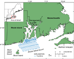
The U.S. Geological Survey (USGS) conducted a high-resolution seismic survey in western Rhode Island Sound during 1980 (fig. 1). Data from this survey were used to determine the local geologic units and stratigraphy (Needell and others, 1983a; 1983b; 1983c). The original seismic records were generated in analog form and are archived at the USGS Woods Hole Science Center's Data Library. In order to make the data more readily accessible to the public and to help preserve the original paper records, the seismic lines were scanned and converted to digital form; they are available as high-resolution black and white Tagged Image File Format (TIFF) images, grayscale Portable Network Graphics (PNG) images, low-resolution Graphics Interchange Format (GIF) preview images, and SEG-Y seismic-data files. Navigation data from the survey are available in space-delimited text, and Environmental Systems Research Institute, Inc. (ESRI) shapefile formats and trackline data are available in ESRI shapefile format. The purpose of this report is to supplement and complement previous work (Poppe and others, 2002) that provided seismic-reflection profiles, core logs, photographs, and navigational data collected in Long Island and Block Island Sounds in digital form. |

![]() U.S. Department of the Interior |
U.S. Geological Survey
U.S. Department of the Interior |
U.S. Geological Survey
URL: https://pubsdata.usgs.gov/pubs/of/2009/1002/html/intro.html
Page Contact Information: Contact USGS
Page Last Modified: Wednesday, 07-Dec-2016 21:55:36 EST