U.S. Geological Survey Open-File Report 2009-1002
Digital Seismic-Reflection Data from Western Rhode Island Sound, 1980
|
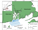
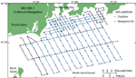
High-resolution seismic-reflection data, along tracklines totaling 580 km in length, were collected aboard the Research Vessel (R/V) Neecho during cruise NECH80-1 (USGS Field Activity Number 80016; fig. 1; Needell and others, 1983b). Seismic data were obtained using a towed EG&G Uniboom system and were printed on an EPC Laboratories, Inc. (EPC) recorder at a quarter-second sweep rate. The Uniboom system operates by emitting acoustic pulses with frequencies of 400 Hz to 8 kHz. Acoustic energy reflected back to the ship from the sea floor and subsurface is detected by a hydrophone array and is converted to an electric signal. The signal is then amplified and filtered to a 400- to 4,000-Hz bandpass. The seismic data have 1- to 2-m vertical resolution. Ship positioning was determined using Long Range Aids to Navigation (LORAN-C) navigation, which has an absolute accuracy of 185 to 463 m (U.S. Coast Guard, 1992). Navigation fixes were recorded manually every 15 minutes and at major course changes (fig. 2). Ship speed averaged about 9 km/h during the seismic surveys. LORAN-C time delays were converted to latitudes and longitudes using LoranGPS software. The cruise used the Group Repetition Interval (GRI) 9960 Northeast U.S. chain and recorded time delays from Caribou, Maine (W), and Carolina Beach, North Carolina (Y), slave transmitters. Seismic-reflection profiles from the survey were digitized and are provided in black and white TIFF, grayscale PNG, grayscale GIF, and SEG-Y formats. The seismic lines were scanned at 300-dpi resolution 8-bit grayscale and saved as TIFFs at the USGS Woods Hole Science Center using an Ideal Contex Crystal TX 40 scanner with IdealScanOS version 2.5.4 software. The TIFFs in this report have been downsampled to 1-bit black and white images with 300-dpi resolution in order to reduce file size while providing a resolution that is great enough so that users can print the TIFFs on plotters at the original scale (approximately 52 cm wide) with little loss of quality. Also provided are 200-dpi grayscale PNG images that more closely represent the seismic lines used to make the SEG-Y files, which are much larger in size. SEG-Y files were created from grayscale TIFFs that were cropped to known start and end locations and resampled in Adobe Photoshop CS2, such that the pixel width is equal to a trace and the pixel height is equal to a time sample. These TIFFs were converted to SEG-Y files using tif2segy, a script written by Andrew MacRae, Saint Mary's University, Halifax, NS, which utilizes Seismic Unix (http://www.cwp.mines.edu/cwpcodes/) and Netpbm image tools. Low-resolution GIF images were created from 200-dpi grayscale TIFFs to serve as preview images for rapid viewing. The images used to make the SEG-Y, PNG, and GIF files were clipped to known start and end locations and were cut in some places during processing; therefore, some of the line segments differ from those of the TIFF images. Fifteen-minute navigation point (n80_1nav.shp) and trackline (n80_1lines.shp) shapefiles were made from the latitudes and longitudes produced using LoranGPS. Fifteen-minute navigation point data are provided in ESRI shapefile format with fields for cruise identification, latitude, longitude, line number (from logbook), date, time, LORAN-C time delays, comments, black and white TIFF line name, and time in minutes after midnight. A line shapefile (n80_1_segylines.shp) was created from the 15-minute navigation point file in order to correspond to the SEG-Y line segments. A shapefile of 1-minute navigation points (n80_1_1minnav_sort.shp) was created using Linear Referencing Tools and XToolsPro in ArcGIS 9.2 by making a route from the SEG-Y line and 15-minute point shapefiles, adding hatches every minute, converting the hatches to a shapefile, and adding attributes to the shapefile. The 1-minute navigation shapefile includes fields for line number, time in hours and minutes, time in minutes after midnight, easting, northing, and shot number. A navigation text file, which can be imported into a seismic interpretation package such as Landmark Graphics Corp. (LGC) Seisworks, was made from the 1-minute navigation shapefile. This space-delimited 1-minute shot-point text file contains fields for unique line identification, shot number, easting, and northing. Seismic data can be accessed from the Seismic Profiles page through the navigation bar on the upper left side of this page or through the GIS Data Catalog section of this report, or downloaded directly from the data/seismics folder when this report is accessed through the DVD-ROM. The GIF preview images can also be accessed through interactive maps on the Seismic Profiles page. Navigation data can be accessed through the GIS Data Catalog section of this report or downloaded directly from the data/nav folder when this report is accessed though the DVD-ROM. Data files are named using a cruise identifier, line number, and line section. For example, n80_102Ac.tif signifies the data are from the cruise NECH80-1 (R/V Neecho in 1980) line 02A, section c, and are saved in TIFF format. Many lines were broken into sections in order to scan them completely; therefore, their names differ slightly from those in the logbook in that a lower-case letter is appended to the name after the line identification, as in the example above for section c. Several lines in the SEG-Y files and the PNG and GIF images needed to be further divided into sections during processing; these line segments are labeled _1, _2, or _3 after the section label.
² Previously published USGS Miscellaneous Field Studies Map MF-1537, by S.W. Needell, C.J. O'Hara, and H.J. Knebel |

![]() U.S. Department of the Interior |
U.S. Geological Survey
U.S. Department of the Interior |
U.S. Geological Survey
URL: https://pubsdata.usgs.gov/pubs/of/2009/1002/html/seismic.html
Page Contact Information: Contact USGS
Page Last Modified: Wednesday, 07-Dec-2016 21:55:53 EST