U.S. Geological Survey Open-File Report 2009–1003
Digital Seismic-Reflection Data from Eastern Rhode Island Sound and Vicinity, 1975–1980
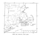
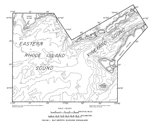
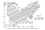
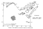
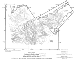
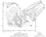
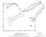
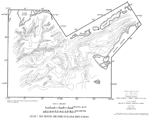
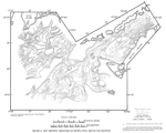
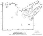
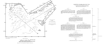
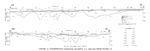
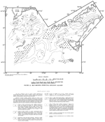
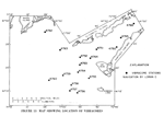
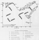
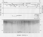
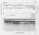
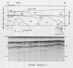
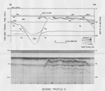
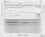
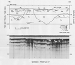
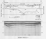
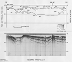
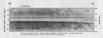
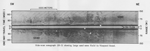
USGS MISCELLANEOUS FIELD STUDIES MAP MF–1186The report presented below (O'Hara and Oldale, 1980) was previously published as a Miscellaneous Field Studies Map by the U.S. Geological Survey and is included here solely to broaden the perspective and understanding of individuals interested in the geologic framework and the Late Quaternary depositional history of Rhode Island Sound. MAPS SHOWING GEOLOGY AND SHALLOW STRUCTURE OF EASTERN RHODE ISLAND SOUND AND VINEYARD SOUND, MASSACHUSETTS Charles J. O'Hara and Robert N. Oldale U.S. Geological Survey Miscellaneous Field Studies Map MF–1186 1980 INTRODUCTION This report presents results of marine studies conducted by the U.S. Geological Survey (USGS) during the summers of 1975 and 1976 in eastern Rhode Island Sound and Vineyard Sound (fig. 1) located off the southeastern coast of Massachusetts. The study was made in cooperation with the Massachusetts Department of Public Works and the New England Division of the U.S. Army Corps of Engineers. It covered an area of the Atlantic Inner Continental Shelf between latitude 41°12' and 41°33'N, and between longitude 70°37' and 71°15'W (see index map). Major objectives included assessment of sand and gravel resources, environmental impact evaluation both of offshore mining of these resources and of offshore disposal of solid waste and dredge spoil material, identification and mapping of the offshore geology, and determination of the geologic history of this part of the Inner Shelf. A total of 670 kilometers (km) of closely spaced high-resolution seismic-reflection profiles, 224 km of side-scan sonar data, and 16 cores totaling 90 meters (m) of recovered sediment, were collected during the investigation. This report is companion to geologic maps published for Cape Cod Bay (Oldale and O'Hara, 1975) and Buzzards Bay, Massachusetts (Robb and Oldale, 1977). ACKNOWLEDGMENTS The authors are indebted to the staffs of the Woods Hole Oceanographic Institution (WHOI), the Marine Biological Laboratory, and the Marine Science Consortium for their cooperation in the use of their research vessels. We thank the Department of Public Works of the Commonwealth of Massachusetts and the New England Division of the Army Corps of Engineers for partial funding in support of this study. To Captains A. Colburn of the R.V. ASTERIAS, D. Von Arx of the R.V.A.E. VERRILL, and G. Van Tassel and crew of the R.V. ANNANDALE, we are indebted for their assistance during the research cruises. Special thanks are extended to M. Rubin and E. Spiker of the USGS and J. Buckley of Teledyne Isotopes for providing radiocarbon dates (14C); to T. Ager, R. Christopher, and N. Frederiksen of the USGS for making palynological age determinations; and to A. Merrill of the Northeast Center of the National Marine Fisheries Service (NMFS) for kindly identifying mollusk assemblages. We appreciate the cooperation and assistance of A. Stockel of Woodward-Clyde Consultants for his field supervision of the vibracoring phase of the study, and C. Finkelstein, formerly of Klein Associates, Inc. and now with Sub Sea Surveyors, Inc., for his field supervision of the side-scan sonar survey. W. Ferrebee, J. McLane, P. Forrestel, R. Commeau, R. Lewis, C. Franks, E. Winget, S. Purdy, B. Tausey, F. Jennings, R. Sylwester, and K. Parolski of the USGS, and S. Briggs and J. Austin of WHOI, were particularly generous with their time and assistance on the various cruises and in the laboratory. For their suggestions and helpful discussions during the preparation of this report, we express our gratitude to J. Robb and C. Kaye of the USGS, to S. Briggs of WHOI, and to C. Hard and G. Chase of the Army Corps of Engineers. We especially thank J. Moller, P. Warwick, and P. Forrestel for drafting the illustrations, and J. Peper and C. Paull for their thorough reviews of the manuscript. METHODS The subbottom seismic-reflection data (fig. 2) were obtained with a surface towed EG&G Unit Pulse Boomer having an energy output of 300 joules nominal at a frequency of 400 Hertz (Hz) to 8 kilohertz (kHz). Reflected acoustic energy was detected by a 4.6-meter, 8-element hydrophone array, amplified, actively filtered (400-to-4000 Hz bandpass), and graphically displayed on an EPC dry paper recorder. The electromechanical transducer was triggered every 0.5 seconds (s) and the sweep rate of the recorder was 0.25 s. Profiler resolution was generally 1 to 1.5 m. The side-scan sonograph data (fig. 3) were obtained with a Klein Side Scan Towfish (sonar frequency, 100 kHz; pulse length, 0.1 millisecond (msec)). Incoming signals from the starboard and port scans were automatically tuned, texture-enhanced, and printed center-out on a Klein wet-paper graphic recorder (75 m and 150 m scan range). All cores (vibracores; figures 13 and 14) were obtained with a Woodward-Clyde Vibratory Corer designed to provide 9-centimeter (cm) diameter cores up to 12 m in length in water depths of 11 m to 70 m. Selection of core sites was based on the nature and subbottom altitude of the acoustic units defined by the seismic-reflection profiles. Navigational control for all the cruises was provided by LORAN-C (positional accuracy within 0.2 km) and was supplemented by radar and visual fixes. Positional information was logged at 15-minute intervals and at major course changes during the geophysical surveys. Average ship speed over the bottom was 9 km/hour (hr) during the seismic-reflection surveys and 7 km/hr for the side-scan survey. Core sites were occupied within 0.03 km of their selected locations from the seismic data. Depths below sea level are based on an assumed compressional-wave velocity of 1500 meters per second (m/s) for water, 1500 m/s for sediments inferred to be of Holocene age, and 1800 m/s for sediments inferred to be of Pleistocene age. Map showing depth to basement and submerged coastal plain rocks Offshore, north of the heavy dashed line in figure 4, contours are drawn on a surface inferred to be underlain by bedrock composed of crystalline rocks and consolidated sedimentary rocks of pre-Mesozoic age. Farther offshore (south of heavy dashed line), contours are drawn on a surface inferred to be underlain by submerged coastal plain or continental shelf rocks composed of mostly unconsolidated sediments of late Mesozoic and early Cenozoic age. Locally, valleys cut into these strata may be floored by bedrock. Insufficient subbottom penetration precluded mapping of this surface beneath the northeastern part of Vineyard Sound. Bedrock Subbottom penetration to the consolidated basement rocks (fig. 15, unit PzZ in profiles A and B) or Fall Zone (Flint, 1963) was limited to the northern part of eastern Rhode Island Sound. Farther offshore, the bedrock reflector was mostly masked by the thick wedge of coastal plain and continental shelf strata that lie seaward of a deeply eroded cuesta (represented by the heavy dashed line on the map, fig. 4). In the seismic-reflection profiles, the bedrock surface (fig. 15, reflector fu2 in profiles A and B) is seen as a strong, continuous, and highly irregular reflector which shallows gradually landward toward metasedimentary, metavolcanic, and plutonic rocks of Proterozoic Z and early Paleozoic age that crop out along the coast of southeastern Rhode Island (Quinn, 1971) and southern Massachusetts (Emerson, 1917). Nearshore, this reflector is found within a few meters of the sea floor and locally crops out on the bottom, notably off Sakonnet Point, R.I. (fig. 10, 11). The prominent valleys seen cut into the basement rocks are most likely the seaward extensions of the buried north-south trending bedrock valleys that occur beneath the adjacent coast (Upson and Spencer, 1964). Although not defined by the seismic profiler seaward of the cuesta during this study, they continue uninterrupted offshore beneath the submerged coastal plain deposits (McMaster and Ashraf, 1973). The basement rocks beneath this part of the study area (north of heavy dashed line in figure 4) are mostly overlain by glacial drift deposits (fig. 15, unit Qdo in profiles A and B) of late Pleistocene age and locally by fluvial and estuarine deposits (fig. 15, unit Qfe in profile A) of Holocene age. Coastal plain deposits Beneath Vineyard Sound and the southern part of eastern Rhode Island Sound, the deepest nearly-continuous and most prominent seismic reflector is thought to be underlain by rocks of Late Cretaceous age, possibly including strata of Tertiary and early Pleistocene age (fig. 15, unit Ku in profiles C, D, E, F, G, and H). These deposits, which represent the submerged parts of the Atlantic Coastal Plain, are inferred to be mostly Upper Cretaceous strata and to consist of unconsolidated to semi-consolidated gravels, sands, silts and clays. Beneath the inner shelf off southern New England, the northern limit of these deposits is defined by a cuesta that extends from western Long Island Sound to eastern Georges Bank (Weed and others, 1974). In the seismic-reflection profiles, the surface of the deposits is seen as a distinct, well-defined, smooth to slightly irregular reflector (fig. 15, reflector fu2 in profiles C, D, E, F, G, and H) that defines a dissected escarpment with numerous deeply cut valleys and adjacent relatively flat-topped interfluves trending mostly north-south. Within the escarpment, internal flat-lying to gently seaward-dipping reflectors are seen, but are discontinuous and truncated by the flanks of the valleys. In some places, folded and steeply dipping reflectors (fig. 15, unit Ku in profile F) occur in the upper parts of the deposits and are inferred to represent folded and thrust-faulted sediments deformed by glacial ice during the late Pleistocene. The coastal plain or continental shelf rocks beneath this part of the study area (south of heavy dashed line in figure 4) are mostly blanketed by glacial drift deposits (fig. 15, unit Qdo in profiles C, D, E, F, G, and H) of late Pleistocene age, but crop out on the sea floor in a few places (fig. 15, profile F; and fig. 16, sonograph SS-2), and are thought to locally occur beneath the Elizabeth Islands. Coastal plain clays recovered in one vibracore (fig. 14, core 4764) were unfossiliferous (Jack McLane, USGS, oral commun., 1977) and are thought to be nonmarine in origin. The folded and faulted deposits that occur beneath the southwestern part of Vineyard Sound are thought to represent the offshore equivalent of the ice-disturbed pre-Pleistocene deposits found within the Gay Head Cliffs on Martha's Vineyard. Tertiary and early Pleistocene (?) drainage The structure contour map (fig. 4) shows a surface inferred to represent a major unconformity (fig. 15, reflector fu2 in all profiles) that was cut by streams during late Tertiary and early Pleistocene time. This extended period of subaerial erosion formed an inner lowland bounded to the north by crystalline rocks and to the south by coastal plain rocks. Drainage within the lowland is thought to have consisted of southward flowing streams on the seaward-dipping Fall Zone surface and northward flowing streams on the north-facing scarp of the cuesta. Valleys defined by the unconformity are believed to be tributary to a drainage system that breached the cuesta through a water gap and drained across the shelf. The water gap may have been located to the west, perhaps beneath Block Island Sound (O'Hara and others, 1976). Subsequent glacial erosion during the Pleistocene probably enlarged the size of the lowland and locally overdeepened some of the valleys, but otherwise little altered the preglacial morphology. Map showing thickness of glacial drift deposits Figure 5 shows the distribution and combined thickness of the acoustic units (fig. 15, unit Qdo in profiles A, B, C, D, E, F, G, and H and unit Qdm shown in profile C) believed to represent glacial drift deposited mostly by the Buzzards Bay ice lobe during its final retreat, northwestward, from southeastern Massachusetts and Rhode Island. In Vineyard Sound, the acoustic unit (Qdo) may also include glacial drift derived from the Cape Cod Bay ice lobe. The drift deposits, ubiquitous in the study area, are inferred to be mostly of late Wisconsinan (Woodfordian) Age, and to correlate with moraines and proglacial outwash found elsewhere in southern New England and on Block Island and Long Island (Schafer, 1961; Schafer and Hartshorn, 1965). However, drift deposits of pre-late Wisconsinan Age similar to those thought to exist on Martha's Vineyard (Kaye, 1964a; 1964b) may occur locally. In the seismic-reflection profiles, the drift deposits are largely well-stratified, being characterized by flat-lying to gently-dipping internal reflectors (most likely representing outwash and ice-contact stratified drift) and by acoustically well-layered sequences consisting of numerous closely-spaced reflectors (most likely representing glaciolacustrine deposits). In other areas, the drift deposits are characterized by highly irregular, discontinuous internal reflectors, numerous parabolic echoes and, locally, imbricate reflectors, all of which suggest deposition (probably till) or modification by overriding ice. In some places, the deposits are acoustically massive, showing little or no internal structure, and in other places, internal reflectors are folded and steeply-dipping, indicating folding and faulting. In the northern part of eastern Rhode Island Sound, the drift deposits unconformably overlie bedrock of pre-Mesozoic age, while in the southern part and in Vineyard Sound these deposits unconformably overlie coastal plain and continental shelf sedimentary rocks of Late Cretaceous age. The drift deposits are thickest, locally up to 180 m, where they bury bedrock valleys and valleys that are deeply cut into the coastal plain escarpment. Deposits are thinnest, generally less than 20 m, near the mainland coast and farther offshore where they cap the pre-glacial topographic highs or coastal plain interfluves. The glacial drift is capped by a major unconformity (fig. 15, reflector fu1 in profiles A, B, C, D, E, F, G, and H) inferred to have been fluvially cut in post-late glacial time during low sea-level and, locally, by a planar marine unconformity (fig. 15, reflector mu in profiles D, E, F, G, and H) inferred to have been cut during sea level rise. Drift deposits are locally overlain by fluvial, estuarine, and marine deposits (fig. 15, units Qfe, Qb and Qm in profiles A, B, C, D, E, F, G, and H) of Holocene age. In eastern Rhode Island Sound, the drift crops out on the sea floor (fig. 10, 11) in many places, forming most of the positive bathymetric features (fig. 1) that are found on this part of the inner shelf. In Vineyard Sound, the drift crops out on the sea floor in a few places, mostly along the shores of the Elizabeth Islands and Martha's Vineyard. Map showing thickness of Buzzards Bay moraine deposits Figure 6 shows the distribution and thickness of the acoustic unit (fig. 15, unit Qdm in profile C) in eastern Rhode Island Sound, thought to represent the submerged extension of the Buzzards Bay end-moraine deposits that form the Elizabeth Islands. The unit is inferred to be a glaciotectonic feature of late Wisconsinan (Woodfordian) Age and to consist mostly of ice-deformed and ice-thrusted stratified drift similar to that found on the islands. Recent field studies (Oldale and O'Hara, 1978) indicate that the moraine deposits forming the Elizabeth Islands are ice-thrust ridges composed of folded and faulted, steeply dipping, proglacial deltaic and lacustrine sediments. A thin cover of subglacial till caps these sediments in most places. The occurrence of well-stratified drift—the Elizabeth Islands—high up on the moraine front, unconformably overlain by basal till, as well as the anomalous up-ice dip and steepness of the beds (dip to northwest is 40° to near vertical) and the occurrence of local folding and faulting, together suggest that the outwash deposits were displaced both horizontally and vertically by overriding ice during a readvance of the ice front. Other nearby evidence for thrusting and deformation by glacial ice is found within the Nantucket moraine at Gay Head Cliffs on Martha's Vineyard (Kaye, 1964b) and in the adjacent offshore area (fig. 15, unit Ku in profile F). Morphologically similar ice-thrusted ridges composed of folded and faulted unconsolidated sediment have been noted in western Canada (Byers, 1959; Kupsch, 1962) and in northwestern Europe (Rutten, 1960). The structural nature of the Buzzards Bay end-moraine deposits suggests that deglaciation of southeastern Massachusetts was characterized by an oscillating ice front responding to short-term fluctuations of the Woodfordian glacial climate. Ice front retreat is thought to have involved stagnation zone retreat alternating with vigorous ice advance in a manner similar to that reported by Frye and Willman (1973) in Illinois, rather than a gradual and steady retreat in response to an ameliorating climate. In the seismic-reflection profiles, the base of the acoustic unit is defined by a very prominent, continuous, and slightly irregular subbottom reflector (fig. 15, reflector at base of unit Qdm in profile C). This reflector dips northwestward and is truncated at or near the sea floor to the southeast. The upper surface of the unit is represented by an irregular sea-floor reflector and farther to the northwest by another prominent, continuous and more steeply northwest-dipping subbottom reflector (not shown in profile C) that merges at depth with the lowermost reflector. These two prominent up-ice dipping reflectors are thought to be basal tills that were deposited as the Buzzards Bay ice lobe readvanced over the ice-contact slope of its previously deposited outwash. Internal reflectors are mostly lacking, but where seen are generally irregular, discontinuous, and occasionally imbricated. The acoustically massive appearance of the unit in the seismic profiles may have been caused by attenuation of the high-frequency acoustic energy by the till cover, or it may have been caused by the homogeneity of the drift, which might preclude sufficient acoustic contrast to resolve any internal bedding or structure. The isopach map (fig. 6) shows an arcuate configuration in the distribution of the acoustic unit especially where it is greater than 50 m thick. The part of the unit shown by dashed contours may represent an inter-ridge low or an area where no ice thrusting occurred, perhaps similar in nature to the passageways that occur between the Elizabeth Islands. Morphostratigraphically, the unit correlates with the morainal ridges that occur on western and northern Cape Cod, along the southern coast of Rhode Island, on Fishers Island, Plum Island, and along the northern part of Long Island (Schafer, 1961). In the study area, the moraine deposits are underlain in most places by older outwash deposits and in some places by coastal plain and continental shelf rocks of Late Cretaceous age. To the northwest the unit is overlain by younger outwash plain deposits, and to the southeast it crops out on the sea floor in a series of southwest-trending topographic ridges and inter-ridge lows (fig. 1) that deepen offshore. Side-scan sonar data (fig. 16, sonograph record SS-1) obtained in this study and submersible vessel observations made by the Army Corps of Engineers (Gib Chase, oral commun., 1977) indicate that these offshore ridges are capped by sand and gravel and large boulders that are thought to be lag from marine erosion of the till cover. In addition, small sand waves were found to occur atop some of these deeply submerged ridges. Map showing structure of glacial drift surface The structure contours (fig. 7) are drawn on a surface underlain by mostly upper Wisconsinan (Woodfordian Age) glacial drift. In some places, the surface may be underlain by bedrock or by coastal plain and continental shelf rocks where they crop out through the drift. The glacial drift surface is overlain in most places by freshwater, estuarine, and marine deposits of Holocene age, but it does crop out on the sea floor (fig. 10, 11) in many places in eastern Rhode Island Sound and in a few places in Vineyard Sound. Postglacial drainage The mapped surface is inferred to represent a major unconformity (fig. 15, reflector fu1 in profiles A, B, C, D, E, F, G, and H) that was fluvially cut in post-late glacial time during the low stand of sea level (O'Hara and others, 1976). The postglacial valleys seen cut into the glacial drift and older deposits have local relief up to 20 m and thalweg depths greater than 55 m below sea level. They form dendritic patterns indicating that drainage was southwestward toward Block Island Sound. In the northern part of eastern Rhode Island Sound, these valleys were tributary to streams that drained the southern coast of Massachusetts and Rhode Island and Buzzards Bay; in Vineyard Sound and in the southern part of eastern Rhode Island Sound, the valleys were tributary to streams that drained western Nantucket Sound. The offshore morainal ridges were drainage divides that precluded southward drainage in eastern Rhode Island Sound. The major valleys of the drainage basins were probably tributary to a much larger river that breached the offshore end moraines perhaps through inter-ridge lows and continued across the continental shelf to the sea. This large valley may have existed in western Rhode Island Sound east of Block Island. The drainage network doubtless developed in direct response to the post-depositional morphology of the glacial drift deposits. Vibracore data indicate that the valleys are filled with mostly estuarine sediments that were deposited as the sea transgressed and gradually drowned the pre-existing fluvially modified glacial drift surface. Radiocarbon dates on freshwater peats obtained nearby in Buzzards Bay (Robb and Oldale, 1977) suggest that postglacial marine submergence of the drift and older deposits on this part of the Atlantic Inner Continental Shelf was not complete prior to 5,000 years before present. Map showing thickness of postglacial (Holocene) deposits Figure 8 shows the distribution and combined thickness of the acoustic units inferred to represent Holocene sediments (fig. 15, units Qfe, Qb and Qm in profiles A, B, C, D, E, F, G, and H) deposited on this part of the inner shelf after the region was completely deglaciated during the post-late Wisconsinan. These sediments occur atop the fluvial unconformity (fig. 15, reflector fu1 in profiles A, B, C, D, E, F, G, and H) cut in post-late glacial time, and consist of pre-transgressive fluvial sand and gravel and freshwater bog deposits, transgressive estuarine and salt marsh deposits, and post-transgressive marine deposits of mostly sand, silt, and clay. The deposits are underlain in most places by upper Pleistocene glacial drift and locally by coastal plain and continental shelf rocks of Late Cretaceous to early Pleistocene (?) age. Pre-Mesozoic basement rocks also locally underlie the Holocene sediments. Deposits are thickest—in places up to 16 m—where they bury the postglacial valleys cut into the glacial drift and older deposits, and where they occur as submerged bars, linear sand ridges, and possible tidal deltas. Deposits are thinnest or absent where they mantle the preglacial and glacial topographic highs. Internal reflectors are mostly flat-lying to gently dipping and show local cross-bedding. Steeply dipping reflectors are seen in some parts of the offshore bars and sand ridges and are thought to represent foreset bedding. In deeper water the deposits are acoustically well-layered with numerous closely-spaced internal reflectors. In some places the unit is acoustically impenetrable. Vibracore samples obtained in these areas (see fig. 12 for locations) indicate that the surficial sediments are highly organic and are saturated with gases of probable biogenic origin. Sample analysis of a freshwater bog peat cored from these deposits (fig. 14, core 4760) suggests cool terrestrial conditions and boreal forests dominated by spruce, pine, and birch in the study area, 13,000 to 14,000 years before present (Thomas Ager, USGS, written commun., 1977). Map showing thickness of beach and bar deposits Figure 9 shows the distribution and thickness of the acoustic unit inferred to represent Holocene beach and bar deposits (fig. 15, unit Qb in profiles F, G, and H). The unit occurs atop a planar marine unconformity (fig. 15, reflector mu in profiles D, E, F, G, and H) that was cut as sea level transgressed across this part of the inner shelf and eroded the estuarine and older deposits. The beach and bar deposits are believed to have been formed during sea-level rise by wave action and by littoral and tidal currents that reworked the inner shelf sediments and redeposited them on the nearly flat-lying wave-cut surface. The deposits consist mostly of medium to very coarse sand containing abundant shell fragments and, locally, small lenses of gravel. The sand and gravel were most likely derived from the adjacent glacial drift deposits, from which the finer-grained material probably was winnowed by currents and transported offshore into deeper water. The deposits are thickest where they occur as linear sand ridges. Locally they are as much as 14 m thick in Vineyard Sound; generally they are less than 8 m thick. Internal reflectors, where seen, are mostly flat-lying and continuous, but in some places are steeply dipping. Dipping reflectors are thought to indicate local foreset bedding. Sand waves (fig. 16, sonograph records SS-3 and SS-4) are numerous in areas of strong tidal flow and suggest that the deposits, in part, are active at present and are responding to the local hydraulic regime; in other areas, the deposits may be relict. The beach and bar deposits are underlain in most places by glacial drift of late Pleistocene age and, locally, by fluvial and estuarine sediments of Holocene age. The sand deposits grade offshore to finer-grained quiet-water deposits consisting of mostly silt and clay. These deposits are considered to be potential sources of sand and possibly gravel for use as construction aggregate. Although the vibracore data indicate a paucity of gravels within the deposits, more detailed sampling is required to determine if commercial quantities exist. In general, significant concentrations of gravel are restricted to the underlying glacial drift and postglacial fluvial sediments. Map showing potential geologic hazards Figure 12 is intended to serve as a guide to future engineering and environmental impact studies relating to offshore mining of sand and gravel deposits, offshore disposal of solid waste and harbor dredge-spoil materials, and possible oil and gas pipeline construction beneath the seabed. Inferences regarding potential geologic hazards are based on the morphology of the sea floor, on the lithology and internal structure of the shallow (upper 10 m) subbottom sediments, and on the geology and geological development of the region deduced from the seismic-reflection, side-scan sonar, and vibracore data. More detailed information on the nature, distribution and thickness of the unconsolidated sediments and the structural configuration of the major seismic horizons that occur on this part of the shelf can be found in figures 4, 5, 6, 7, 8, and 9. REFERENCES CITED Byers, A.R., 1959, Deformation of the Whitemud and Eastend Formations near Claybank, Saskatchewan: Transactions of the Royal Society of Canada, v. 53, p. 1-11. Emerson, B.K., 1917, Geology of Massachusetts and Rhode Island: U.S. Geological Survey Bulletin 597, 289 p. Flint, R.F., 1963, Altitude, lithology, and the Fall Zone in Connecticut: Journal of Geology, v. 71, p. 683-697. Frye, J.C., and Willman, H.B., 1973, Wisconsinan climatic history interpreted from Lake Michigan lobe deposits and soils: Geological Society of America Memoir 136, p. 135-152. Kaye, C.A., 1964a, Outline of Pleistocene geology of Martha's Vineyard, Massachusetts: U.S. Geological Survey Professional Paper 501-C, p. C134-C139. Kaye, C.A., 1964b, Illinoian and early Wisconsin moraines of Martha's Vineyard, Massachusetts: U.S. Geological Survey Professional Paper 501-C, p. C140-C143. Kupsch, W.O., 1962, Ice-thrust ridges in western Canada: Journal of Geology, v. 70, p. 582-594. McMaster, R.L., and Ashraf, Asaf, 1973, Subbottom basement drainage system of Inner Continental Shelf off southern New England: Geological Society of America Bulletin, v. 84, p. 187-190. O'Hara, C.J., Oldale, R.N., and Robb, J.M., 1976, Late Tertiary, Pleistocene, and Holocene development of the Inner Continental Shelf off southeastern Massachusetts (abs): Geological Society of America Abstracts with Programs, v. 8, no. 6, p. 1033. Oldale, R.N., and O'Hara, C.J., 1975, Preliminary report on the geology and sand and gravel resources of Cape Cod Bay, Massachusetts: U.S. Geological Survey Open-File Report 75-112, 9 pls., scale 1:80,000. Oldale, R.N., and O'Hara, C.J., 1978, Thrusted coastal end moraines and a Woodfordian fluctuating ice margin: evidence from Massachusetts onshore and offshore areas (abs.): Geological Society of America Abstracts with Programs, v. 10, no. 2, p. 78. Quinn, A.W., 1971, Bedrock geology of Rhode Island: U.S. Geological Survey Bulletin 1295, 68 p. Robb, J.M., and Oldale, R.N., 1977, Preliminary geologic maps, Buzzards Bay, Massachusetts: U.S. Geological Survey Miscellaneous Field Studies Map MF-889. Rutten, M.G., 1960, Ice-pushed ridges, permafrost and drainage: American Journal of Science, v. 258, p. 293-297. Schafer, J.P., 1961, Correlation of end moraines in southern Rhode Island: U.S. Geological Survey Professional Paper 424-D, p. D68-D70. Schafer, J.P., and Hartshorn, J.H., 1965, The Quaternary of New England, in Wright, H.E., Jr., and Frey, D.G., eds., The Quaternary of the United States: Princeton, N.J., Princeton University Press, p. 113-128. Upson, J.E., and Spencer, C.W., 1964, Bedrock valleys of the New England coast as related to fluctuations of sea level: U.S. Geological Survey Professional Paper 454-M, 44 p. Weed, E.G.A., Minard, J.P., Perry, W.J., Jr., Rhodehamel, E.C., and Robbins, E.I., 1974, Generalized pre-Pleistocene geologic map of the northern United States Atlantic continental margin: U.S. Geological Survey Miscellaneous Investigations Map I-861. |

![]() U.S. Department of the Interior |
U.S. Geological Survey
U.S. Department of the Interior |
U.S. Geological Survey
URL: https://pubsdata.usgs.gov/pubs/of/2009/1003/html/eris_sum.html
Page Contact Information: Contact USGS
Page Last Modified: Wednesday, 07-Dec-2016 22:15:52 EST