U.S. Geological Survey Open-File Report 2009-1039
Summary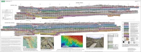
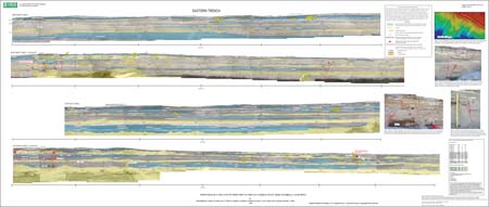
The Coachella paleoseismic site is located on the San Andreas Fault along the northeast edge of the Coachella Valley in southern California east of Dillon Road and south of Avenue 44. Three benched trenches, a total of more than 950 m, were excavated across the fault zone as part of an Alquist-Priolo fault investigation study. These trenches exposed a thick section of latest Holocene lacustrine, fluvial, and shoreline deposits. Only the central and eastern trenches exposed faulting so we confined our investigations to those two trenches. In the central trench, we photographed and logged in detail both walls of about 70 m of the trench where it spanned several zones of complex faulting which form a 15-m-wide depression. After carefully cleaning the trench walls, we put up a 1- by 0.5-m string- and nail-grid. We photographed each 1- by 0.5-m panel individually and then photologged features directly on these unrectified photos. The photos were digitally rectified later to remove distortion caused by irregularities in the trench walls and to correct the slight distortion introduced by the camera lens. The rectified photos were spliced together to make photomosaics of the trench walls. Most of the field linework and descriptions were then transferred to the rectified photomosaics. For the eastern trench, we took a set of overview photographs of the full length (about 200 m) of each wall. These photographs were taken from the top of the trench towards the opposite wall. Because the photographs were taken at a downward angle, there is significant distortion. We logged directly on these photos in the field, recording significant contacts, primarily between lacustrine and subaerial deposits, along with descriptions. For this report, we spliced together these unrectified overview photos and transfered field linework and some descriptions. For both trenches, contacts and lithologhic descriptions of stratigraphic units, faults and carbon sample locations are indicated on the photomosaics. Lacustrine deposits are tinted to better show deformation across the fault zones. Evidence for six paleoearthquakes rated as “probable” is indicated with red stars that contain the sequential event number (1 is most recent event). Evidence for two additional “possible” paleoearthquakes is indicated with blue stars. The sedimentary deposits contain abundant dateable material which includes detrital charcoal, lenses of organic material formed in-situ, and shells. Two organic fractions, humic acids and acid-alkali-acid-pretreated (AAA), were dated for 13 of 15 samples taken from organic layers and both dates are shown for these samples on the photomosaics and tables 1 and 2. All radiocarbon dates are in 14C years B.P. (considered to be A.D. 1950). Horizontal distance is measured along the trenches from the southwest ends of the logged exposures (marked as 0 m), and depth is measured from the highest points on the ground surface within the logged exposures. Bench locations are indicated by white lines and gaps in the photomosaics. Note that faults and contacts that are somewhat oblique to the trench walls occasionally appear disconnected owing to the approximately 1 m width of the benches. |
Posted March 13, 2009 Part or all of this report is presented in Portable Document Format (PDF); at least version 7 of Adobe Reader or similar software is required to view it. Download the latest version of Adobe Reader, free of charge. |
Philibosian, Belle, Fumal, Thomas E., Weldon II, Ray J., Kendrick, Katherine J., Scharer, Katherine M., Bemis, Sean P., Burgette, Reed J., and Wisely, Beth A., 2009, Photomosaics and logs of trenches on the San Andreas Fault near Coachella, California: U.S. Geological Survey Open-File Report 2009-1039, 2 sheets [https://pubs.usgs.gov/of/2009/1039/].

![]() U.S. Department of the Interior |
U.S. Geological Survey
U.S. Department of the Interior |
U.S. Geological Survey
URL: http://
pubsdata.usgs.gov
/pubs/of/2009/1039/index.html
Page Contact Information: USGS Publications Team
Page Last Modified: Wednesday, 07-Dec-2016 21:51:02 EST