U.S. Geological Survey Open-File Report 2009–1231
Integrated Multibeam and LIDAR Bathymetry Data Offshore of New London and Niantic, Connecticut
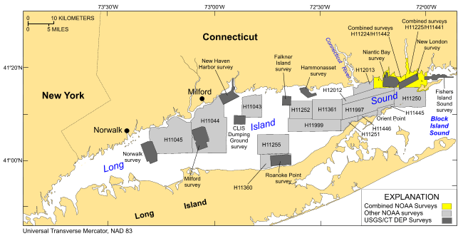 |
Figure 1. Map showing locations of the combined LIDAR/multibeam bathymetric surveys off New London and Niantic, Connecticut, in northeastern Long Island Sound. Also shown are the sites of other National Oceanic and Atmospheric Administration (NOAA) bathymetric surveys and U.S. Geological Survey/Connecticut Department of Environmental Protection (USGS/CT DEP) sidescan-sonar surveys in Long Island Sound. Bathymetric surveys: H11250--Poppe and others (2006b, 2007a); H11255--Poppe and others (2006c); H11252/H11361--Poppe and others (2007b, 2008); H11043--Poppe and others (2004); H11444--McMullen and others (2005), Poppe and others (2006a); H11045--Beaulieu and others (2005). Sidescan-sonar surveys: Norwalk--Twichell and others (1997); Milford--Twichell and others (1998); New Haven harbor and Central Long Island Sound (CLIS) Dumping Ground--Poppe and others (2001); Roanoke Point--Poppe and others (1999a); Falkner Island--Poppe and others (1999b); Hammonasset--Poppe and others (1997); Niantic Bay--Poppe and others (1998a); New London--Lewis and others (1998), Zajac and others (2000, 2003); Fishers Island Sound--Poppe and others (1998b). |

![]() U.S. Department of the Interior |
U.S. Geological Survey
U.S. Department of the Interior |
U.S. Geological Survey
URL: https://pubsdata.usgs.gov/pubs/of/2009/1231/html/fig1.html
Page Contact Information: Contact USGS
Page Last Modified: Wednesday, 07-Dec-2016 22:24:55 EST


