U.S. Geological Survey Open-File Report 2009–1231
Integrated Multibeam and LIDAR Bathymetry Data Offshore of New London and Niantic, Connecticut
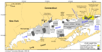
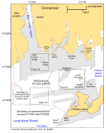
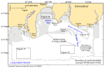
The U.S. Geological Survey (USGS), in cooperation with National Oceanic and Atmospheric Administration (NOAA) and the Connecticut Department of Environmental Protection (CT DEP), is producing detailed maps of the sea floor in Long Island Sound (fig. 1). The current phase of this cooperative research program is directed toward studies of sea-floor topography and its effect on the distributions of sedimentary environments and benthic communities. Because anthropogenic wastes, toxic chemicals, and changes in land-use patterns resulting from residential, commercial, and recreational development have stressed the environment of the Sound and caused degradation and potential loss of benthic habitats (Koppelman and others, 1976; Long Island Sound Study, 1994), detailed maps of the sea floor are needed to evaluate the extent of adverse effects and to manage resources wisely in the future. The purpose of this report is to release the integrated bathymetric data from hydrographic surveys conducted off Niantic and New London, Connecticut, in northeastern Long Island Sound (figs. 2, 3). Bathymetric Light Detection and Ranging (LIDAR) was used to acquire data in the shallower, nearshore areas (surveys H11224 and H11225); multibeam echosounders were used in the deeper areas farther offshore (surveys H11441 and H11442). These datasets have been combined into complete-coverage Environmental Systems Research Institute (ESRI) raster grids and GeoTIFF imagery of the sea floor in order to provide a continuous offshore-to-nearshore representation. These bathymetric datasets serve many purposes, including (1) defining the topographic variability of the sea floor, which is one of the primary controls on benthic habitat diversity; (2) improving our understanding of the oceanographic processes that control the distribution and transport of bottom sediments and the distribution of benthic habitats and associated infaunal community structures; and (3) providing a detailed framework for future research, monitoring, and management activities. These datasets also serve as base maps for subsequent sedimentological, geochemical, and biological observations, because precise information on topography and environmental setting is needed for the selection of sampling sites and for accurate extrapolation and interpretation of point measurements. |
Click on figures for larger images.
|

![]() U.S. Department of the Interior |
U.S. Geological Survey
U.S. Department of the Interior |
U.S. Geological Survey
URL: https://pubsdata.usgs.gov/pubs/of/2009/1231/html/intro.html
Page Contact Information: Contact USGS
Page Last Modified: Wednesday, 07-Dec-2016 22:25:06 EST