U.S. Geological Survey Open-File Report 2010-1006
Geophysical and Sampling Data from the Inner Continental Shelf: Northern Cape Cod Bay, Massachusetts
Click on an image below for a higher resolution image.
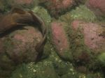
 dl4_PICT0248.JPG Station # 166A Lat 42.015052 Long -70.524241 Time(UTC) 00:34:47 |
 dl4_PICT0249.JPG Station # 166A Lat 42.015060 Long -70.524260 Time(UTC) 00:35:10 |
 dl4_PICT0250.JPG Station # 166B Lat 42.015085 Long -70.524237 Time(UTC) 00:45:08 |
 dl4_PICT0251.JPG Station # 166B Lat 42.015060 Long -70.524236 Time(UTC) 00:46:01 |
 dl4_PICT0252.JPG Station # 166B Lat 42.015024 Long -70.524264 Time(UTC) 00:46:46 |
|||
 dl4_PICT0253.JPG Station # 166B Lat 42.014952 Long -70.524357 Time(UTC) 00:47:10 |
 dl4_PICT0254.JPG Station # 166B Lat 42.014796 Long -70.524580 Time(UTC) 00:48:07 |
 dl4_PICT0255.JPG Station # 166B Lat 42.014689 Long -70.524767 Time(UTC) 00:48:59 |
 dl4_PICT0256.JPG Station # 166B Lat 42.014555 Long -70.524951 Time(UTC) 00:49:53 |
 dl4_PICT0257.JPG Station # 166B Lat 42.014479 Long -70.525054 Time(UTC) 00:50:22 |
|||
 dl4_PICT0258.JPG Station # 166B Lat 42.014414 Long -70.525152 Time(UTC) 00:50:47 |
 dl4_PICT0259.JPG Station # 166B Lat 42.014365 Long -70.525232 Time(UTC) 00:51:08 |
 dl4_PICT0260.JPG Station # 166B Lat 42.014286 Long -70.525348 Time(UTC) 00:51:41 |
 dl4_PICT0261.JPG Station # 166B Lat 42.014236 Long -70.525424 Time(UTC) 00:52:04 |
 dl4_PICT0262.JPG Station # 167 Lat 42.006811 Long -70.549581 Time(UTC) 01:09:10 |
|||
 dl4_PICT0263.JPG Station # 167 Lat 42.006642 Long -70.549695 Time(UTC) 01:09:51 |
 dl4_PICT0264.JPG Station # 167 Lat 42.006442 Long -70.549824 Time(UTC) 01:10:41 |
 dl4_PICT0265.JPG Station # 167 Lat 42.006312 Long -70.549929 Time(UTC) 01:11:17 |
 dl4_PICT0266.JPG Station # 167 Lat 42.006081 Long -70.550104 Time(UTC) 01:12:16 |
 dl4_PICT0267.JPG Station # 167 Lat 42.005747 Long -70.550361 Time(UTC) 01:13:45 |
|||
 dl4_PICT0268.JPG Station # 167 Lat 42.005547 Long -70.550477 Time(UTC) 01:14:36 |
 dl4_PICT0269.JPG Station # 167 Lat 42.005249 Long -70.550645 Time(UTC) 01:15:51 |
 dl4_PICT0270.JPG Station # 167 Lat 42.005093 Long -70.550726 Time(UTC) 01:16:31 |
 dl4_PICT0271.JPG Station # 167 Lat 42.004919 Long -70.550817 Time(UTC) 01:17:17 |
 dl4_PICT0272.JPG Station # 167 Lat 42.004861 Long -70.550857 Time(UTC) 01:17:34 |
|||
 dl4_PICT0273.JPG Station # 168 Lat 41.970648 Long -70.548410 Time(UTC) 01:41:04 |
 dl4_PICT0274.JPG Station # 168 Lat 41.970570 Long -70.548488 Time(UTC) 01:41:27 |
 dl4_PICT0275.JPG Station # 168 Lat 41.970407 Long -70.548625 Time(UTC) 01:42:10 |
 dl4_PICT0276.JPG Station # 168 Lat 41.970342 Long -70.548686 Time(UTC) 01:42:29 |
 dl4_PICT0277.JPG Station # 168 Lat 41.970299 Long -70.548726 Time(UTC) 01:42:42 |
|||
 dl4_PICT0278.JPG Station # 168 Lat 41.970221 Long -70.548790 Time(UTC) 01:43:05 |
 dl4_PICT0279.JPG Station # 168 Lat 41.970083 Long -70.548901 Time(UTC) 01:43:44 |
 dl4_PICT0280.JPG Station # 168 Lat 41.969952 Long -70.549003 Time(UTC) 01:44:20 |
 dl4_PICT0281.JPG Station # 168 Lat 41.969810 Long -70.549134 Time(UTC) 01:45:05 |
 dl4_PICT0282.JPG Station # 168 Lat 41.969629 Long -70.549287 Time(UTC) 01:45:55 |
|||
 dl4_PICT0283.JPG Station # 169 Lat 41.973451 Long -70.584086 Time(UTC) 04:53:45 |
 dl4_PICT0284.JPG Station # 169 Lat 41.973423 Long -70.584092 Time(UTC) 04:54:01 |
 dl4_PICT0285.JPG Station # 169 Lat 41.973348 Long -70.584097 Time(UTC) 04:54:49 |
 dl4_PICT0286.JPG Station # 169 Lat 41.973010 Long -70.584154 Time(UTC) 04:57:43 |
 dl4_PICT0287.JPG Station # 169 Lat 41.972938 Long -70.584178 Time(UTC) 04:58:20 |
|||
 dl4_PICT0288.JPG Station # 169 Lat 41.972910 Long -70.584186 Time(UTC) 04:58:34 |
 dl4_PICT0289.JPG Station # 169 Lat 41.972793 Long -70.584226 Time(UTC) 04:59:29 |
 dl4_PICT0290.JPG Station # 170 Lat 41.962266 Long -70.602067 Time(UTC) 05:19:37 |
 dl4_PICT0291.JPG Station # 170 Lat 41.962221 Long -70.602073 Time(UTC) 05:19:57 |
 dl4_PICT0292.JPG Station # 170 Lat 41.962007 Long -70.602083 Time(UTC) 05:21:33 |
|||
 dl4_PICT0293.JPG Station # 170 Lat 41.961952 Long -70.602083 Time(UTC) 05:21:58 |
 dl4_PICT0294.JPG Station # 170 Lat 41.961871 Long -70.602091 Time(UTC) 05:22:34 |
 dl4_PICT0295.JPG Station # 170 Lat 41.961597 Long -70.602088 Time(UTC) 05:24:42 |
|||||


