08016_SWATHPLUS_TRK.SHP: Bathymetric trackline navigation collected by the U.S. Geological Survey within the St. Clair River between Michigan and Ontario, Canada, 2008 (ESRI VECTOR SHAPEFILE)

Metadata also available as - [Outline] - [Parseable text]

Frequently-anticipated questions:


What does this data set describe?

Title:
08016_SWATHPLUS_TRK.SHP: Bathymetric trackline navigation collected by the U.S. Geological Survey within the St. Clair River between Michigan and Ontario, Canada, 2008 (ESRI VECTOR SHAPEFILE)
Abstract:
In 2008, the U.S. Geological Survey (USGS), Woods Hole Coastal and Marine Science Center (WHCMSC), in cooperation with the U.S. Army Corps of Engineers conducted a geophysical and sampling survey of the riverbed of the Upper St. Clair River between Port Huron, MI, and Sarnia, Ontario, Canada. The objectives were to define the Quaternary geologic framework of the St. Clair River to evaluate the relationship between morphologic change of the riverbed and underlying stratigraphy. This report presents the geophysical and sample data collected from the St. Clair River, May 29-June 6, 2008 as part of the International Upper Great Lakes Study, a 5-year project funded by the International Joint Commission of the United States and Canada to examine whether physical changes in the St. Clair River are affecting water levels within the upper Great Lakes, to assess regulation plans for outflows from Lake Superior, and to examine the potential effect of climate change on the Great Lakes water levels ( <http://www.iugls.org>). This document makes available the data that were used in a separate report, U.S. Geological Survey Open-File Report 2009-1137, which detailed the interpretations of the Quaternary geologic framework of the region. This report includes a description of the suite of high-resolution acoustic and sediment-sampling systems that were used to map the morphology, surficial sediment distribution, and underlying geology of the Upper St. Clair River during USGS field activity 2008-016-FA . Video and photographs of the riverbed were also collected and are included in this data release. Future analyses will be focused on substrate erosion and its effects on river-channel morphology and geometry. Ultimately, the International Upper Great Lakes Study will attempt to determine where physical changes in the St. Clair River affect water flow and, subsequently, water levels in the Upper Great Lakes.
  1. How should this data set be cited?

    U.S. Geological Survey, 2010, 08016_SWATHPLUS_TRK.SHP: Bathymetric trackline navigation collected by the U.S. Geological Survey within the St. Clair River between Michigan and Ontario, Canada, 2008 (ESRI VECTOR SHAPEFILE): Open-File Report 2010-1035, U.S. Geological Survey, Coastal and Marine Geology Program, Woods Hole Coastal and Marine Science Center, Woods Hole, MA.

    Online Links:

    This is part of the following larger work.

    Denny, Jane F. , Foster, David S. , Worley, Charles R. , and Irwin, Barry J. , 2010, Geophysical data collected from the St. Clair River between Michigan and Ontario, Canada, 2008-016-FA: Open-File Report 2010-1035, U.S. Geological Survey, Coastal and Marine Geology Program, Woods Hole Coastal and Marine Science Center, Woods Hole, MA.

    Online Links:

  2. What geographic area does the data set cover?

    West_Bounding_Coordinate: -82.513962
    East_Bounding_Coordinate: -82.401909
    North_Bounding_Coordinate: 43.017471
    South_Bounding_Coordinate: 42.655537

  3. What does it look like?

    <https://pubs.usgs.gov/of/2010/1035/gis_catalog/tracklines/bathy_trk_sm.jpg> (JPEG)
    Thumbnail image of trackline navigation for swath bathymetric system

  4. Does the data set describe conditions during a particular time period?

    Beginning_Date: 29-May-2008
    Ending_Date: 01-Jun-2008
    Currentness_Reference: ground condition

  5. What is the general form of this data set?

    Geospatial_Data_Presentation_Form: vector digital data

  6. How does the data set represent geographic features?

    1. How are geographic features stored in the data set?

      This is a Vector data set. It contains the following vector data types (SDTS terminology):

      • String (88)

    2. What coordinate system is used to represent geographic features?

      Horizontal positions are specified in geographic coordinates, that is, latitude and longitude. Latitudes are given to the nearest 0.000001. Longitudes are given to the nearest 0.000001. Latitude and longitude values are specified in Decimal degrees.

      The horizontal datum used is D_WGS_1984.
      The ellipsoid used is WGS_1984.
      The semi-major axis of the ellipsoid used is 6378137.000000.
      The flattening of the ellipsoid used is 1/298.257224.

  7. How does the data set describe geographic features?

    08016_swathplus_trk
    ESRI Polyline Shapefile (Source: ESRI)

    FID
    Internal feature number. (Source: ESRI)

    Sequential unique whole numbers that are automatically generated.

    Shape
    Feature geometry. (Source: ESRI)

    Coordinates defining the features.

    Line
    bathymetric line number (Source: U.S. Geological Survey)

    USGS naming classification for collected lines of data. The format is: L1F1, where L=line, 1= Number, F=File, and 1=File number (hrb=lines collected within the harbor)

    JD
    Julian Day of data collection (Year 2008) with day 1 equal to January 1, 2008 (Source: U.S. Geological Survey)

    Range of values
    Minimum:150
    Maximum:153
    Units:Julian Day (Year 2008)

    Length
    length of line (km) (Source: U.S. Geological Survey)

    Range of values
    Minimum:0.121928
    Maximum:6.980052
    Units:kilometers

    Year
    Calendar year of data collection (Source: U.S. Geological Survey)

    Calendar year USGS cruise 08016 was conducted

    CruiseID
    USGS Unique cruise identification, where the first two digits represent the calendar year and the last three digits represent the cruise number (Source: U.S. Geological Survey)

    ValueDefinition
    08016USGS Cruise Identification Number

    System
    Swath bathymetric system used for data acquisition (Source: U.S. Geological Survey)

    Swath bathymetric system used to acquire data.


Who produced the data set?

  1. Who are the originators of the data set? (may include formal authors, digital compilers, and editors)

  2. Who also contributed to the data set?

  3. To whom should users address questions about the data?

    Jane Denny
    U.S. Geological Survey
    Geologist
    384 Woods Hole Road
    Woods Hole, MA 02543
    USA

    508-548-8700 x2311 (voice)
    508-457-2310 (FAX)
    jdenny@usgs.gov


Why was the data set created?

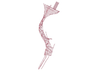
This data set contains trackline navigation for approximately 100 km of swath bathymetric data collected by the U.S. Geological Survey during cruise 08016 within the St. Clair River between Michigan and Ontario, Canada, 2008


How was the data set created?

  1. From what previous works were the data drawn?

    (source 1 of 1)
    U.S. Geological Survey.

    Type_of_Source_Media: disc
    Source_Contribution:
    Swath-bathymetric and acoustic-backscatter data were acquired with a SEA, Ltd., SWATHplus interferometric sonar operating at a 234-kHz frequency (<http://www.sea.co.uk/swathplus.aspx?nav=products>). The SWATHplus transducer was mounted at the bow of the USGS R/V Rafael. Bathymetric data were acquired over variable swath widths ranging from 10 to 100 m, in water depths of about 1 to 25 m. A total of 109 km of swath bathymetric data were collected.

    SWATHplus acquisition software (version 3.05.90) was used to digitally log the bathymetric data at a rate of 30 pings/second and 3,072 samples per swath (ping) in the SWATHplus SXR format. Data collection parameters are saved into a SWATHplus session file in SEA's SXS format. These files that can be later used for data replay.

    An Octopus F180R Attitude and Positioning system (see: <http://www.codaoctopus.com/motion/f180/index.asp>) recorded ship motion (heave, pitch, roll, and yaw). These data were transmitted via network connection to the SWATHplus data collection software. The Octopus F180R Inertial Measurement Unit (IMU) was mounted directly above the SWATHplus transducers, to minimize lever arm offsets that can lead to positioning errors. The F180R uses two L1 antennas for position and heading accuracy. The antennas are mounted on a rigid horizontal pole, 3 meters above the F180R IMU, with a horizontal separation of 1 meter and are offset from the IMU in a forward/aft configuration. The forward offset of the primary antenna from the IMU is 0.5 meters, with no port/starboard offset.

    Eight sound-velocity profiles were acquired during survey operations at roughly 4-hr intervals using an Applied Microsystems SV Plus V2 Velocimeter (Applied Microsystems, 2008).

  2. How were the data generated, processed, and modified?

    Date: 2008 (process 1 of 5)
    Ten second navigation data were extracted from raw swath bathymetric files (SWATHplus SXR format) using SwathEd (no version) bathymetric processing software's 'unravel' routine (Beaudoin, 2002) and saved as ASCII text files for each bathymetric file.

    Person who carried out this activity:

    Jane Denny
    U.S. Geological Survey
    Geologist
    384 Woods Hole Rd.
    Woods Hole, MA 02543-1598

    (508) 548-8700x2311 (voice)
    5084572310 (FAX)
    jdenny@usgs.gov

    Date: 2008 (process 2 of 5)
    A C-shell script was used to reformat the output of the ASCII text files to include: easting, northing, line number, Julian day, hour, minute, second and concatenate the line files into one comma-delimited ASCII text file.

    Person who carried out this activity:

    Jane Denny
    U.S. Geological Survey
    Geologist
    384 Woods Hole Rd.
    Woods Hole, MA 02543-1598

    (508) 548-8700x2311 (voice)
    5084572310 (FAX)
    jdenny@usgs.gov

    Date: 2008 (process 3 of 5)
    The text file (*.csv) was imported into ESRI ArcMap 9.2 using Tools - Add XY Data and converted to an event theme. The event theme was then saved to a point shapefile and the projection was defined as UTM, Zone 17N, meters, WGS84. The point shapefile was visually inspected for spurious data points and removed.

    Person who carried out this activity:

    U.S. Geological Survey
    c/o Jane Denny
    Geologist
    384 Woods Hole Road
    Woods Hole, MA 02543
    USA

    508 548-8700 x 2311 (voice)
    508 457-2310 (FAX)
    jdenny@usgs.gov

    Date: 2008 (process 4 of 5)
    The point shapefile containing 10-second navigation was used as an input for a VACExtras (version 1.8), a VB collection of tools developed by VeeAnn Cross (USGS-WHCMSC), which converts point data to a new polyline shapefile, based on the order of records contained within one attribute field within the file and a unique line identifier field. The line number field was used to define the point order and as the unique line identifier.

    Person who carried out this activity:

    Jane Denny
    U.S. Geological Survey
    Geologist
    384 Woods Hole Road
    Woods Hole, MA 02543
    USA

    508 548-8700 x 2311 (voice)
    508-457-2310 (FAX)
    jdenny@usgs.gov

    Date: 2009 (process 5 of 5)
    The length of each line segment was calculated and included in a new attribute field using XTools Pro for ArcGIS desktop (version 6.2.0), specifying UTM Zone 17 N, WGS84 - kilometers. Year, System and Cruise_ID fields were added to the attribute table within ArcMap 9.2.

    Arc Toolbox, Data Management Tools, Projections and Transformations, Project was then used to project the shapefile from UTM, Zone 17 N, meters, WGS84 to Geographic Coordinate system, WGS84.

    Person who carried out this activity:

    Jane Denny
    U.S. Geological Survey
    Geologist
    384 Woods Hole Road
    Woods Hole, MA 02543
    USA

    508 548-8700 x 2311 (voice)
    508 457-2310 (FAX)
    jdenny@usgs.gov

  3. What similar or related data should the user be aware of?

    Foster, David S. , and Denny, Jane F. , 2009, Quaternary Geologic Framework of the St. Clair River between Michigan and Ontario, Canada: Open-File Report 2009-1137, U.S. Geological Survey, Coastal and Marine Geology Program, Woods Hole Coastal and Marine Science Center, Woods Hole, MA.

    Online Links:

    Beaudoin, Jonathan, 2002, Hitchhiker's Guide to Swathed...: University of New Brunswick Ocean Mapping Group, Fredericton, New Brunswick.

    Online Links:

    • htp://www.omg.unb.ca/~jonnyb/processing/definitive_swathed/


How reliable are the data; what problems remain in the data set?

  1. How well have the observations been checked?

  2. How accurate are the geographic locations?

    Differential Global Positioning System (DGPS) navigation data were acquired with the forward, or primary, Octopus F180R Attitude and Positioning system DGPS antenna and transmitted via a network connection to the SWATHplus data collection software. The F180R Attitude and Positioning system uses 2 L1 antennas for position and heading and an Inertial Measurement Unit (IMU) for motion sensing. The F180R IMU is mounted on the rigid sidemount used to deploy the SWATHplus bathymetric system, and is located directly above the SWATHplus transducers. The F180R antennas are mounted on a rigid horizontal pole, 3 meters above the F180R IMU, offset in a forward/aft configuration (see 'source contribution' for a full description of the F180R). DGPS accuracy is 1 to 3 meters, depending on the distance from a US Coast Guard coastal repeater station (<http://www.navcen.uscg.gov/>).

  3. How accurate are the heights or depths?

  4. Where are the gaps in the data? What is missing?

    All swath bathymetric navigation data were used to generate the trackline shapefile.

  5. How consistent are the relationships among the observations, including topology?

    All bathymetric data were collected during USGS cruise 08016 using a SWATHplus 234-kHz swath bathymetric system and an Octopus F180R Attitude and Positioning System. Quality control was conducted during processing of the data. Any spurious data or artifacts were removed or minimized.


How can someone get a copy of the data set?

Are there legal restrictions on access or use of the data?

Access_Constraints: None
Use_Constraints:
Public domain data from the U.S. Government are freely redistributable with proper metadata and source attribution. Please recognize the U.S. Geological Survey as the originator of the dataset.

  1. Who distributes the data set? (Distributor 1 of 1)

    Jane Denny
    U.S. Geological Survey
    Geologist
    384 Woods Hole Road
    Woods Hole, MA 02543
    USA

    508-548-8700 x2311 (voice)
    508-457-2310 (FAX)
    jdenny@usgs.gov

  2. What's the catalog number I need to order this data set?

    Downloadable Data

  3. What legal disclaimers am I supposed to read?

    Neither the U.S. Government, the Department of the Interior, nor the USGS, nor any of their employees, contractors, or subcontractors, make any warranty, express or implied, nor assume any legal liability or responsibility for the accuracy, completeness, or usefulness of any information, apparatus, product, or process disclosed, nor represent that its use would not infringe on privately owned rights. The act of distribution shall not constitute any such warranty, and no responsibility is assumed by the USGS in the use of these data or related materials.

    Any use of trade, product, or firm names is for descriptive purposes only and does not imply endorsement by the U.S. Government.

  4. How can I download or order the data?

  5. What hardware or software do I need in order to use the data set?

    This zip file contains data available in Environmental Systems Research Institute (ESRI) polyline shapefile format. The user must have ArcGIS or ArcView 3.0 or greater software to read and process the data file. In lieu of ArcView or ArcGIS, the user may utilize another GIS application package capable of importing the data. A free data viewer, ArcExplorer, capable of displaying the data is available from ESRI at www.esri.com.


Who wrote the metadata?

Dates:
Last modified: 25-Jan-2011
Metadata author:
U.S. Geological Survey
c/o Jane F. Denny
Geologist
384 Woods Hole Road
Woods Hole, MA 02536
USA

508-548-8700 x2311 (voice)
508-457-2310 (FAX)
jdenny@usgs.gov

Metadata standard:
FGDC Content Standards for Digital Geospatial Metadata (FGDC-STD-001-1998)
Metadata extensions used:


Generated by mp version 2.8.25 on Tue Jan 25 17:15:36 2011