U.S. Geological Survey Open-File Report 2009-1137
Abstract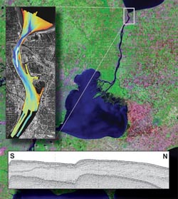 Concern about the effect of geomorphic changes in the St. Clair River on water levels in the Upper Great Lakes resulted in the need for information on the geologic framework of the river. A geophysical survey of the Upper St. Clair River between Port Huron, MI, and Sarnia, Ontario, Canada, was conducted to determine the Quaternary geologic framework of the region. Previously available and new sediment samples and photographic and video data support the interpretation of the seismic stratigraphy and surficial geology. Three seismic stratigraphic units and two unconformities were identified. Glacial drift, consisting of interbedded till and glaciolacustrine deposits, overlies shale. Glaciofluvial and modern fluvial processes have eroded the glacial drift. Glaciofluvial, glaciolacustrine, fluvial, and lacustrine deposits overlie this unconformity. Seismic facies were interpreted to identify areas where these geologic facies exist; however, in the absence of distinct boundaries between facies, these deposits were mapped as one undifferentiated unit. This unit is thickest in the northernmost 3 kilometers of the river, where it consists of relatively coarse-grained fluvial, reworked glaciofluvial, and possibly glaciofluvial deposits. To the south, this coarse-grained unit thins or is absent. The undifferentiated unit comprises most of the surficial deposits in the northernmost river area. Some areas of glacial drift, predominantly till, are exposed at the lake and riverbed. The shale is not exposed anywhere in the region. Geophysical surveys at sites downriver, together with the results of previous studies, indicate that the geologic framework is similar to that in the northernmost river area except for the absence or reduced thickness of the coarse-grained fluvial deposits. Instead, glacial drift is exposed at the riverbed or is covered by a veneer of sediment. This information on the substrate is important for ongoing sediment transport studies.
|
This report is available only on the Web. For additional information contact: Part or all of this report is presented in Portable Document Format (PDF); the latest version of Adobe Reader or similar software is required to view it. Download the latest version of Adobe Reader, free of charge. |
Foster, David S., and Denny, Jane F., 2009, Quaternary geologic framework of the St. Clair River between Michigan and Ontario, Canada: U.S. Geological Survey Open-File Report 2009-1137, available online at https://pubs.usgs.gov/of/2009/1137/.
Data Acquisition and Processing
Swath Bathymetry and Acoustic Backscatter
Morphology, Seismic Stratigraphy, and Surficial Geology: Marysville, Michigan
Morphology, Seismic Stratigraphy, and Surficial Geology: Port Lambton, Ontario

![]() U.S. Department of the Interior |
U.S. Geological Survey
U.S. Department of the Interior |
U.S. Geological Survey
URL: https://pubsdata.usgs.gov/pubs/of/2009/1137/
Page Contact Information: Contact USGS
Page Last Modified: Wednesday, 07-Dec-2016 21:58:09 EST
