Skip past header information
USGS - science for a changing world
NOAA Logo with link to NOAA Home Page.CT DEP Logo with link to CT DEP Home Page.  

U.S. Geological Survey Open-File Report 2010–1150

Sea-Floor Geology and Topography Offshore in Eastern Long Island Sound


Skip past contents information

Title | List of Figures | Conversion Factors | Abstract | Introduction | Methods | Bathymetry | Sediment Distribution | Bottom Photography | GIS Data Catalog | Summary | Acknowledgments | References | Contacts


Figure 16. A bathymetric image of a scour depression in the study area.

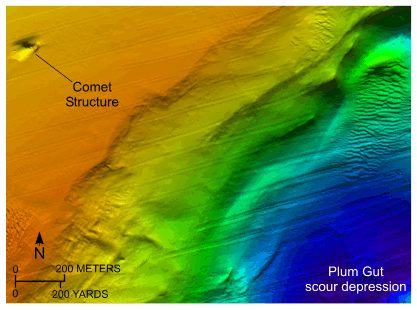
Figure 16. Detailed planar view of the large scour depression at the northern entrance to Plum Gut from the digital terrain model produced from bathymetric data collected during National Oceanic and Atmospheric Administration survey H11997. Note the presence of a comet structure suggesting westward transport and the small sand-wave field in the scour depression. Location of view is shown in figure 12.

Skip USGS links group

Accessibility FOIA Privacy Policies and Notices

Take Pride in America logo USAGov logo U.S. Department of the Interior | U.S. Geological Survey
End of USGS links group