U.S. Geological Survey Open-File Report 2010-1332
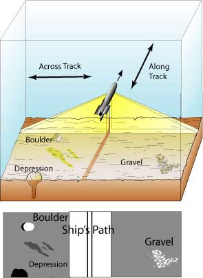
Figure 4. Towfish is shown at the apex of across-track beam of energy (yellow fan-shaped area) and the resulting sonograph. Previously insonified area shown as light grey area, with corresponding image to features depicted below. The ship's nadir is represented on the sonograph as a thin white line, and the two black sections adjacent to the nadir represent the water-column which is removed during processing. The brown stripe below the towfish shows the along-track dimension. Figure adapted from Able, K.W., Twichell, D.C., Grimes, C.B., and Jones, R.S., 1987, Sidescan sonar as a tool for detection of demersal fish habitats: Fishery Bulletin, v. 85, p. 725-736. Graphic courtesy of U.S. Geological Survey, Coastal and Marine Science Center, Woods Hole, MA 02543. |