U.S. Geological Survey Open-File Report 2010-1332
GLORIA Sidescan-Sonar Imagery for Parts of the U.S. Exclusive Economic Zone and Adjacent Areas
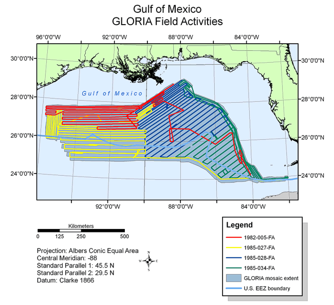
BackgroundThe Gulf of Mexico is a small, geologically diverse ocean basin that can be divided into three distinct provinces: a salt deformation province underlying the continental slope in the northwest Gulf, the Mississippi Canyon and Fan system in the central Gulf, and a carbonate province along its eastern boundary (McGregor and others, 1985). The GLORIA image of this U.S. EEZ area covers approximately 412,000 sq km of seafloor from the shelf edge seaward. The Gulf of Mexico was surveyed using GLORIA during four cruises each approximately one month in duration and organized during two separate years. The first cruise, in February 1982 (1982-005-FA), focused on the continental slope seaward of Texas and Louisiana in the northern Gulf of Mexico. Three more surveys (1985-027-FA, 1985-028-FA and 1985-034-FA) were completed in the summer and fall of 1985. The first 1985 survey (1985-027-FA), from August 7 to September 3, 1985, covered an area in the western Gulf of Mexico seaward of Texas and Louisiana, and the Mississippi Canyon and Fan system, abutting the 1982 survey. The second survey (1985-028-FA), in September 1985, focused on the central Gulf of Mexico on the Mississippi Fan seaward of Louisiana, Mississippi, Alabama, and Florida. The final survey (1985-034-FA), in October 1985, surveyed the edge of the carbonate platform in the Gulf, concentrating on the West Florida Escarpment and the straits of Florida (Twichell and others, 1996).
|