Skip past header information
USGS - science for a changing world
NOAA Logo with link to NOAA Home Page.  

U.S. Geological Survey Open-File Report 2011–1005

Surficial Geology of the Sea Floor in Central Rhode Island Sound Southeast of Point Judith, Rhode Island


Bathymetry

Skip past contents information
Click on figures for larger images
Thumbnail image of figure 2 and link to larger figure. A map showing the location of end moraines in southern New York and New England.
Figure 2. Map of end moraines and submerged ridges in southern New York and New England with location of study area.
Thumbnail image of figure 11 and link to larger figure. Image of bathymetry in study area.
Figure 11. Hill-shaded multibeam bathymetry from National Oceanic and Atmospheric Administration survey H11996.
Thumbnail image of figure 12 and link to larger figure. A map showing the interpretations of bathymetry data.
Figure 12. Interpretation of sea-floor features in the multibeam bathymetry from National Oceanic and Atmospheric Administration survey H11996.
Thumbnail image of figure 13 and link to larger figure. An image of bathymetry showing scour depressions.
Figure 13. Detailed multibeam bathymetry showing scour depressions on a bathymetric high in the eastern part of the study area.
Thumbnail image of figure 14 and link to larger figure. An image showing sand waves in the study area.
Figure 14. Detailed multibeam bathymetry showing sand waves with east-west oriented crests.
Thumbnail image of figure 15 and link to larger figure. Bathymetry imagery showing trawl marks and a hummocky bathymetric high.
Figure 15. Detailed multibeam bathymetry of trawl marks on the flanks of a hummocky bathymetric high.
Thumbnail image of figure 16 and link to larger figure. Bathymetry image showing dredge spoils in the study area.
Figure 16 . Detailed multibeam bathymetry of dredge spoils located in disposal site 69b.

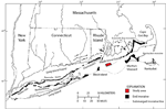
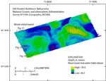
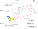
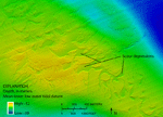
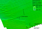
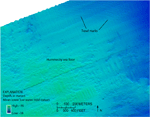
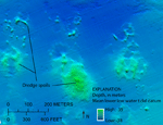
The bathymetry in the study area consists of several isolated bathymetric highs with depths as shallow as 30 m, separated by a system of connected channel-like bathymetric lows with depths up to 40 m (fig. 11). Several sea-floor features can be identified in the bathymetric imagery, including scour depressions, sand waves, trawl marks, and dredge spoils (fig. 12). The scour depressions, which are found in a variety of shapes from broad to elongate, occur on top and on the flanks of bathymetric highs. The depressions have steep sides, relatively flat floors, and are 10s to 100s of meters wide and about 0.5 m deep (fig. 13). Elongate depressions are more common on the flanks of the bathymetric highs. Further descriptions of scour depressions and the surrounding sea floor are discussed in the Bottom Photography section of this report. Sand waves located in the southwestern corner of the study area have wavelengths from several meters to more than 40 m and east-west oriented crests (fig. 14). The bathymetric high in the northwest has a hummocky appearance, which is probably a product of coalesced scour depressions and exposed underlying Pleistocene deposits. Trawl marks are present on the flanks of the bathymetric high and appear as thin depressed lines, often parallel to each other (fig. 15). This high is part of the submerged moraine, dating to 18,000 years ago (Uchupi and others, 2001), trending southeast from Point Judith, R.I. (fig. 2). A bathymetric low in the western edge of the study area has been used as a disposal site for the Providence River and Harbor, site 69b (Science Applications International Corporation, 2004), and contains distinct mounds of dredged material (fig. 16).

Skip USGS links group

Accessibility FOIA Privacy Policies and Notices

Take Pride in America logo USAGov logo U.S. Department of the Interior | U.S. Geological Survey
End of USGS links group