U.S. Geological Survey Open-File Report 2011–1005
Surficial Geology of the Sea Floor in Central Rhode Island Sound Southeast of Point Judith, Rhode Island
![]() Title |
List of Figures |
Conversion Factors |
Abstract |
Introduction |
Setting |
Methods |
Bathymetry |
Sediments |
Bottom Photography |
GIS Data Catalog |
Summary |
Acknowledgments |
References |
Contacts
Title |
List of Figures |
Conversion Factors |
Abstract |
Introduction |
Setting |
Methods |
Bathymetry |
Sediments |
Bottom Photography |
GIS Data Catalog |
Summary |
Acknowledgments |
References |
Contacts
 |
||
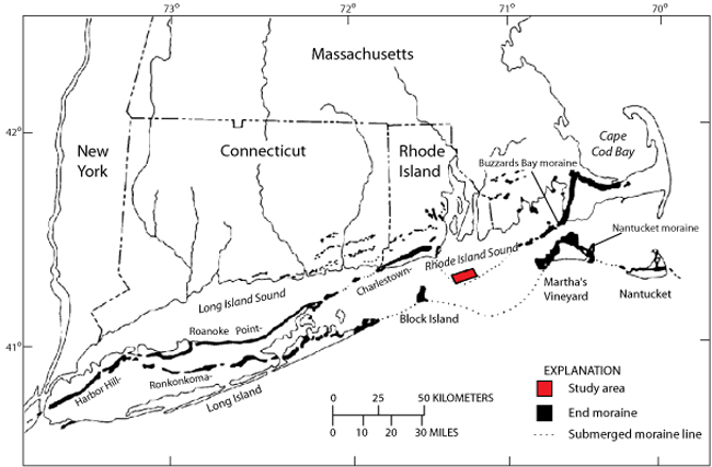
Figure 2. Map of end moraines (black polygons) and submerged ridges (dashed lines) in southern New York and New England (modified from Gustavson and Boothroyd, 1987) with location of study area (red polygon). The Ronkonkoma-Block Island-Nantucket end moraine represents the maximum advance of the Laurentide Ice Sheet about 20,000 to 24,000 years ago, and the Harbor Hill-Roanoke Point-Charleston-Buzzards Bay end moraine represents a retreated ice-sheet position from about 18,000 years ago (Uchupi and others, 2001). The submerged moraine crosses through the western part of the study area. |
||


