U.S. Geological Survey Open-File Report 2011–1005
Surficial Geology of the Sea Floor in Central Rhode Island Sound Southeast of Point Judith, Rhode Island
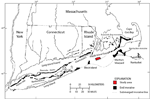
The Rhode Island Sound sea floor, which stretches offshore of Rhode Island from Block Island to Martha's Vineyard, is dominated by glacial and transgressional sediments. About 20,000-24,000 years ago, the Laurentide Ice Sheet reached its maximum southern extent, a position marked by the Ronkonkoma-Nantucket terminal moraine that stretches across Long Island, Block Island, Martha's Vineyard, and Nantucket (fig. 2; Uchupi and others, 2001). As the ice sheet retreated northward, stillstands or readvances left a series of recessional end moraines. For example, the ice sheet had retreated to a position marked by the Harbor Hill-Roanoke Point-Charlestown-Buzzards Bay moraine line about 18,000 years ago (Uchupi and others, 2001). Proglacial lakes, which formed between the retreating ice sheet and the preceding end-moraine line, at times covered much of the area presently occupied by Long Island Sound, Block Island Sound, Narragansett Bay, and Rhode Island Sound (Needell and others, 1983; Uchupi and others, 2001). These lakes eventually drained through a network of fluvial channels, and the area was subaerially exposed. As sea level rose and transgressed across the shelf, waves and currents reworked glacial and glaciolacustrine sediments and deposited Holocene estuarine and marine sediments in parts of Rhode Island Sound (Needell and others, 1983). |