U.S. Geological Survey Open-File Report 2011–1005
Surficial Geology of the Sea Floor in Central Rhode Island Sound Southeast of Point Judith, Rhode Island
![]() Title |
List of Figures |
Conversion Factors |
Abstract |
Introduction |
Setting |
Methods |
Bathymetry |
Sediments |
Bottom Photography |
GIS Data Catalog |
Summary |
Acknowledgments |
References |
Contacts
Title |
List of Figures |
Conversion Factors |
Abstract |
Introduction |
Setting |
Methods |
Bathymetry |
Sediments |
Bottom Photography |
GIS Data Catalog |
Summary |
Acknowledgments |
References |
Contacts
 |
||
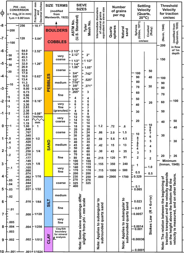
Figure 9. Chart showing the relations among phi sizes, millimeter diameters, size classifications (Wentworth, 1922), and American Society for Testing and Materials and Tyler sieve sizes. Chart also shows the corresponding intermediate diameters, grains per milligram, settling velocities, and threshold velocities for traction. |
||


