Skip past header information
USGS - science for a changing world
NOAA Logo with link to NOAA Home Page.Massachusetts CZM Logo with link to MA CZM Home Page.  

U.S. Geological Survey Open-File Report 2011–1222

Sea-Floor Geology and Sedimentary Processes in the Vicinity of Cross Rip Channel, Nantucket Sound, Offshore Southeastern Massachusetts


Skip past contents information

Title | List of Figures | Conversion Factors | Abstract | Introduction | Setting | Methods | Bathymetry | Sediment Distribution | Bottom Photography | GIS Data Catalog | Summary | Acknowledgments | References | Contacts


Figure 16. A chart showing grain-size relationships.

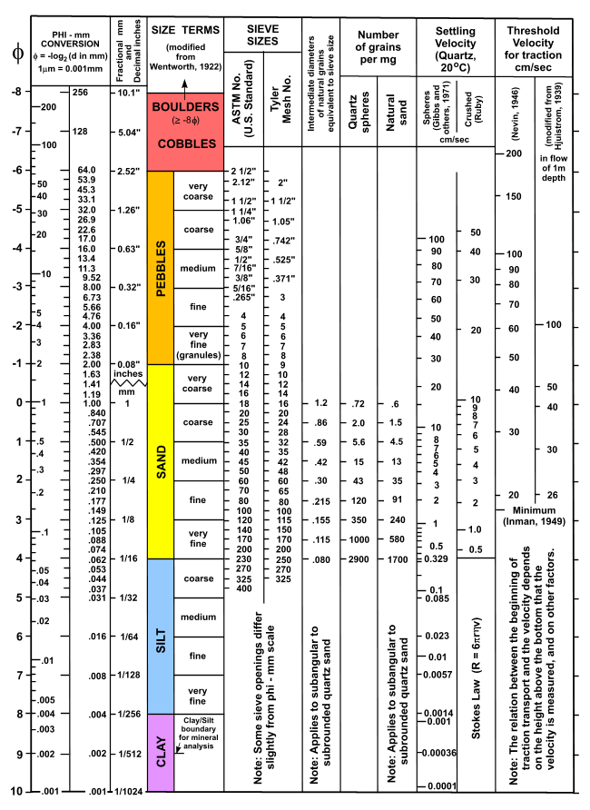
Figure 16. Correlation chart showing the relations among sediment phi size, diameter in millimeters, size classification (Wentworth, 1922), and American Society for Testing Materials (ASTM) and Tyler sieve sizes. Chart also shows the corresponding intermediate diameters, grains per milligram, settling velocities, and threshold velocities for traction.

Skip USGS links group

Accessibility FOIA Privacy Policies and Notices

Take Pride in America logo USAGov logo U.S. Department of the Interior | U.S. Geological Survey
End of USGS links group