U.S. Geological Survey Open-File Report 2011–1222
Sea-Floor Geology and Sedimentary Processes in the Vicinity of Cross Rip Channel, Nantucket Sound, Offshore Southeastern Massachusetts
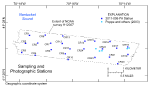
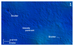
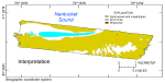
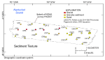
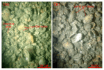
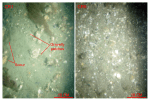
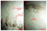
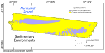
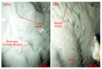
Sediments and Sedimentary EnvironmentsSurface-sediment texture in the study area ranges from boulders to fine sand; no muddy lithologies are present (fig. 30). Surface sediments are coarsest within Cross Rip Channel. Scattered boulders are present at the channel's western end (fig. 21) and are evidence that winnowed Pleistocene glacial deposits crop out on the sea floor. Dense shell beds appear to be thin and patchy, cover the seabed along the axis of the channel, and constitute more than 6 percent of the sea floor within the study area (fig. 22); gravels and gravelly sands underlie the shell beds, and gravelly sands were observed on the channel walls. The shell beds are composed mainly of surf clam, quohog, and Crepidula valves that are typically encrusted with living Crepidula, barnacles, and hydrozoans (fig. 31). The extent and amount of encrustation indicate that the shells have been exposed on the sea floor for an extended time, and some of the surf clams within the shell beds are alive. These shell beds are ecologically important because they form sea-floor habitats of rough, relatively hard substrates that add considerably to the overall benthic compositional complexity. Bottom photography shows that infauna construct burrows in the shell deposits, juvenile finfish shelter between the shells, and sessile fauna and flora attach themselves to the hard substrate provided by the shells. The gravels and gravelly sediments armor the channel's sea floor and limit further erosion. The gravelly sediments on the channel walls are patchy, are flat to faintly rippled, exhibit scour features around the larger obstructions, and have substantial amounts of shell debris (fig. 32). Some places in the southeastern section of the study area, where the Holocene cover is thin or absent, also exhibit patches of gravelly sediment. There the sea floor is flat and longitudinal ripples, an erosional bedform, and scour features around obstructions are common (fig. 33). Together, these are high-energy, sediment-starved areas where sedimentary environments associated with the processes of erosion and nondeposition prevail (fig. 34). Sand dominates in the southeastern part of the study area and on the upper flanks and tops of Cross Rip, Horseshoe, and Half Moon Shoals (fig. 30). Bottom photography in these areas reveals a sea floor with well-developed current ripples that have shell hash concentrated in the ripple troughs, and sedimentary environments characterized by processes associated with coarse-bedload transport (figs. 34, 35). Sand associated with the upper flanks and tops of shoals and in the fields of megaripples tends to be moderately well to moderately sorted; sand in the flatter areas where the Holocene section is thin tends to be more poorly sorted. Sediment DataThe sediment-grain-size dataset provided in the Data Catalog section of this report contains information on the collection, location, description, and texture of sediments at 24 stations occupied during the 2011 RV Rafael verification cruise 2011-006-FA (figs. 15, 30). All analyses were conducted in the Sedimentation Laboratory at the USGS Woods Hole Coastal and Marine Science Center in Woods Hole, Mass. Records without textural data and statistics are based on visual descriptions. The basic structure of the data is a flat-file format, a matrix where records are rows representing individual samples and the columns contain sample- and station-specific information. This matrix consists of 42 fields, which are defined in the Data Dictionary below. The sediment data are provided in three formats: ESRI shapefile, Microsoft Excel, and delimited ASCII text format. In the delimited ASCII text file, each field or column of data is separated from the next by commas and can be downloaded into many types of software. These files are available through the Data Catalog section of this report. Data DictionaryAn integral part of any database is the dictionary that explains the structure and content. It contains a list of the fields and the definitions of parameters measured. Data utilization is facilitated by reference to this compilation because it defines abbreviations and lists field names. LABNO - Unique sample identifier assigned in the laboratory STATIONID - Sample name or number assigned in the field PROJECT - Project under which samples were collected or data generated CRUISEID - Name or number of cruise on which sample was collected or station occupied PRINCIPAL - Name of principal investigator LATITUDE - Latitude in decimal degrees LONGITUDE - Longitude in decimal degrees (west longitudes are negative values) DEPTH_M - Depth of water measured by a hull-mounted fathometer overlying sediment at the time of sampling, not corrected for tides, in meters T_DEPTH - Top depth of the sample below the sediment-water interface, in centimeters B_DEPTH - Bottom depth of the sample below the sediment-water interface, in centimeters DEVICE - Device used to collect the sample MONTH - Number of calendar month during which the sample was collected DAY - Calendar day on which the sample was collected YEAR - Calendar year during which the sample was collected WEIGHT - Dry weight of sample, in grams ZGRAVEL - Gravel content in percent dry weight of the sample (particles with nominal diameters greater than 2 millimeters (-1 phi and larger)) ZSAND - Sand content in percent dry weight of the sample (particles with nominal diameters less than 2 millimeters but greater than or equal to 0.0625 millimeters (0 through 4 phi)) ZSILT - Silt content in percent dry weight of the sample (particles with nominal diameters less than 0.0625 millimeters but greater than or equal to 0.004 millimeters (5 through 8 phi)) ZCLAY - Clay content in percent dry weight of the sample (particles with nominal diameters less than 0.004 millimeters (9 phi and smaller)) SEDCLASS - Sediment description based on a rigorous definition (Shepard, 1954; Schlee, 1973; Poppe and others, 2004):
MEDIAN - Middle point in the grain-size distribution, in phi units MEAN - Average value in the grain-size distribution, in phi units STDDEV - Standard deviation (root mean square of the deviations) of the grain-size distribution, in phi units (that is, sorting) SKEWNESS - Deviation from symmetrical form of the grain-size distribution KURTOSIS - Degree of curvature near the mode of the grain-size distribution PHI _11 - Weight percent of the sample in the 11-phi fraction (nominal diameter of particles greater than or equal to 0.0005 millimeters but less than 0.001 millimeters); fine clay PHI_10 - Weight percent of the sample in the 10-phi fraction (nominal diameter of particles greater than or equal to 0.001 millimeters but less than 0.002 millimeters); medium clay PHI_9 - Weight percent of the sample in the 9-phi fraction (nominal diameter of particles greater than or equal to 0.002 millimeters but less than 0.004 millimeters); coarse clay PHI_8 - Weight percent of the sample in the 8-phi fraction (nominal diameter of particles greater than or equal to 0.004 millimeters but less than 0.008 millimeters); very fine silt PHI_7 - Weight percent of the sample in the 7-phi fraction (nominal diameter of particles greater than or equal to 0.008 millimeters but less than 0.016 millimeters); fine silt PHI_6 - Weight percent of the sample in the 6-phi fraction (nominal diameter of particles greater than or equal to 0.016 millimeters but less than 0.031 millimeters); medium silt PHI_5 - Weight percent of the sample in the 5-phi fraction (nominal diameter of particles greater than or equal to 0.031 millimeters but less than 0.0625 millimeters); coarse silt PHI_4 - Weight percent of the sample in the 4-phi fraction (nominal diameters of particles greater than or equal to .0625 millimeters but less than 0.125 millimeters); very fine sand PHI_3 - Weight percent of the sample in the 3-phi fraction (nominal diameter of particles greater than or equal to 0.125 millimeters but less than 0.25 millimeters); fine sand PHI_2 - Weight percent of the sample in the 2-phi fraction (nominal diameter of particles greater than or equal to 0.25 millimeters but less than 0.5 millimeters); medium sand PHI_1 - Weight percent of the sample in the 1-phi fraction (nominal diameter of particles greater than or equal to 0.5 millimeters but less than 1 millimeter); coarse sand PHI_0 - Weight percent of the sample in the 0-phi fraction (nominal diameters of particles greater than or equal to 1 millimeter but less than 2 millimeters); very coarse sand PHIM1 - Weight percent of the sample in the -1-phi fraction (nominal diameter of particles greater than or equal to 2 millimeters but less than 4 millimeters); very fine pebbles (granules) PHIM2 - Weight percent of the sample in the -2-phi fraction (nominal diameter of particles greater than or equal to 4 millimeters but less than 8 millimeters); fine pebbles PHIM3 - Weight percent of the sample in the -3-phi fraction (nominal diameter of particles greater than or equal to 8 millimeters but less than 16 millimeters); medium pebbles PHIM4 - Weight percent of the sample in the -4-phi fraction (nominal diameter of particles greater than or equal to 16 millimeters but less than 32 millimeters); coarse pebbles PHIM5 - Weight percent of the sample in the -5-phi fraction (nominal diameter of particles greater than or equal to 32 millimeters); very coarse pebbles to boulders |