Skip past header information
USGS - science for a changing world
NOAA Logo with link to NOAA Home Page.Massachusetts CZM Logo with link to MA CZM Home Page.  

U.S. Geological Survey Open-File Report 2011–1222

Sea-Floor Geology and Sedimentary Processes in the Vicinity of Cross Rip Channel, Nantucket Sound, Offshore Southeastern Massachusetts


Skip past contents information

Title | List of Figures | Conversion Factors | Abstract | Introduction | Setting | Methods | Bathymetry | Sediment Distribution | Bottom Photography | GIS Data Catalog | Summary | Acknowledgments | References | Contacts


Figure 34. Map of sedimentary environments in the study area.

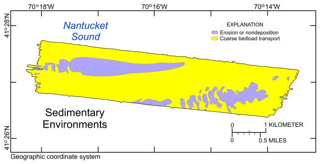
Figure 34. Distribution of sedimentary environments based on the digital terrain model produced from National Oceanic and Atmospheric Administration survey H12007 and the sampling and photography data from USGS cruise 2011-006-FA that were used to verify the acoustic data. Areas characterized by processes associated with erosion or nondeposition and coarse bedload transport are shown.

Skip USGS links group

Accessibility FOIA Privacy Policies and Notices

Take Pride in America logo USAGov logo U.S. Department of the Interior | U.S. Geological Survey
End of USGS links group