Skip past header information
USGS - science for a changing world
CZM logo with link to CZM home page

U.S. Geological Survey Open-File Report 2012-1006

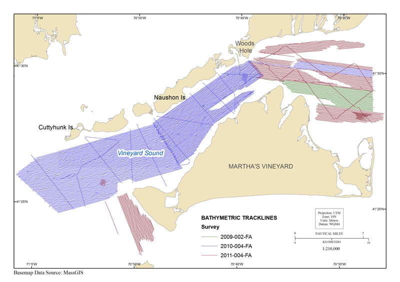
High-Resolution Geophysical Data From the Inner Continental Shelf at Vineyard Sound, Massachusetts


Skip past contents information/ Title Page/ List of Figures / Conversion Factors / Abstract / Introduction / Data Collection / Acknowledgments / References Cited / Geospatial Data / Index /


map showing tracklines where bathymetry data were collected in the vineyard sound survey area


Figure 4. Map showing tracklines along which bathymetry data were collected in the Vineyard Sound, Massachusetts, survey area. Tracklines are color coded by U.S. Geological Survey (USGS) survey number. Abbreviations on figure are explained in the Abbreviations.

Download the full size image in jpg format (1.98 KB).


To view files in PDF format, download a free copy of Adobe Reader.


Accessibility FOIA Privacy Policies and Notices

Take Pride in America logo USA.gov logo U.S. Department of the Interior | U.S. Geological Survey
URL: http://pubsdata.usgs.gov/pubs/of/2012/1006/figure4.html
Page Contact Information: GS Pubs Web Contact
Page Last Modified: Wednesday, 28-May-2014 15:03:25 EDT