U.S. Geological Survey Open-File Report 2012-1006
High-Resolution Geophysical Data From the Inner Continental Shelf at Vineyard Sound, Massachusetts
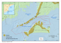
This report presents high-resolution geophysical data of the seafloor in Vineyard Sound, Massachusetts (fig. 1), collected during three surveys between 2009 and 2011. Approximately 340 square kilometers (km2) of the inner continental shelf within Vineyard Sound was mapped between the State border to the west and Cape Pogue to the east. This report is the ninth in a series (Barnhardt and others, 2006, 2009, 2010; Ackerman and others, 2006, Andrews and others, 2010; Pendleton and others, 2011; Turecek and others, 2012; S.D. Ackerman and others, U.S. Geological Survey, written commun., October 2012) published through a cooperative mapping program between the U.S. Geological Survey (USGS) and the Massachusetts Office of Coastal Zone Management (CZM). The program focuses on the inshore waters of coastal Massachusetts primarily in water between 3 and 30 meters deep. The long-term objectives of this mapping program are to provide a framework for scientific research and develop geologic information for the management of coastal and marine resources. High-resolution spatial data and derivative maps of seafloor geology are fundamental baseline information required for fisheries management and habitat studies, delineating marine resources, and assessing environmental changes caused by natural processes or human activities. This report documents the data collection and processing methods used during three surveys conducted between 2009 and 2011. The appendix of this report contains the processed geophysical data (bathymetry, acoustic-backscatter intensity, and seismic-reflection profiles), which are integrated within a geographic information system (GIS) to facilitate future management decisions and research. In addition, these data will form the basis for interpretive marine geologic maps that will be published for the region. Geologic SettingVineyard Sound is a narrow seaway in southeastern Massachusetts that connects western Nantucket Sound to the Atlantic Ocean between Cape Cod and the Elizabeth Islands and Martha's Vineyard (fig. 1). The geology of Vineyard Sound is a product of glacial processes related to late Pleistocene advance and retreat of the Buzzards Bay lobe of the Laurentide Ice Sheet and fluvial and marine processes associated with postglacial relative sea level (O'Hara and Oldale, 1980; Oldale and O'Hara, 1984). The eastern margin of Vineyard Sound was established when the Buzzards Bay ice lobe reached its maximum extent about 23,000 years before present (BP) and formed the western part of the Martha's Vineyard terminal moraine (fig.1; Oldale and O'Hara, 1984; Uchupi and others, 1996; Balco and others, 2002). As the ice began to recede northward, ice contact, outwash, and glaciolacustrine sediments were deposited between the retreating ice front and the Martha's Vineyard moraine (O'Hara and Oldale, 1980). About 18,000 years BP, the western margin of the sound was established when the Buzzards Bay ice lobe readvanced across previously deposited glacial drift and formed the Buzzards Bay moraine (fig. 1; Oldale and O'Hara, 1984; Uchupi and others, 1996; Balco and others, 2002). Nearshore areas of Vineyard Sound are generally high relief, consisting of rugged exposures of boulders located within glacial outwash deposits along the margins of the bounding moraines (O'Hara and Oldale, 1980). As deglaciation continued, subaerially exposed preglacial and glacial drift deposits in Vineyard Sound were deeply incised by fluvial runoff from melting ice and proglacial lake drainage (O'Hara and Oldale, 1980; Uchupi and others, 1996). The drainage valleys were partially filled by fluvial and estuarine sediment as sea level rose and submerged Vineyard Sound during the later Holocene (O'Hara and Oldale, 1980). From the time of submergence (less than 5,000 years BP; O'Hara and Oldale, 1980), wind-driven waves and strong tidal and littoral currents have reworked the preglacial, glacial, and postglacial sediments of Vineyard Sound to form large linear sand ridges, fields of sand waves, and smaller rippled bedforms (O'Hara and Oldale, 1980).
|

![]() U.S. Department of the Interior |
U.S. Geological Survey
U.S. Department of the Interior |
U.S. Geological Survey
URL: http://pubsdata.usgs.gov/pubs/of/2012/1006/introduction.html
Page Contact Information: GS Pubs Web Contact
Page Last Modified: Wednesday, 28-May-2014 14:57:07 EDT