Skip past header information
USGS - science for a changing world

U.S. Geological Survey Open-File Report 2012–1008

National Assessment of Shoreline Change: A GIS Compilation of Vector Shorelines and Associated Shoreline Change Data for the Pacific Northwest Coast


Geospatial Data

Skip past contents information
Click on figures for larger images.
Thumbail image for Figure 1 and link to full size figure.  Map showing rate coverage and shoreline locations in Washington

Figure 1. Map showing locations where long- and short-term rates of shoreline change were calculated based on extent of available shoreline data in Washington.

Thumbail image for Figure 1, image of the RV Woodsholer, and link to full-sized figure.

Figure 2. Map showing locations where long- and short-term shoreline change were calculated based on extent of available shoreline data in Oregon..

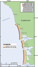
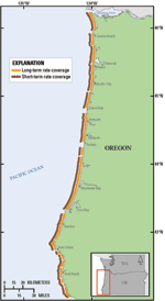
Data in this report are available as downloadable files organized by state. The index maps (figs. 1 and 2) highlight areas of shoreline coverage in orange (long-term rate coverage) and brown (short-term rate coverage) for Washington and Oregon. All vector data are delivered as ESRI shapefiles in the geographic coordinate system (World Geodetic System datum of 1984) and distributed with extensible markup language (*.xml) format metadata generated by ArcCatalog and Federal Geographic Data Committee (FGDC) compliant metadata files. Tabular data are delivered as dBase IV (*.dbf) structured files which can be read with ArcGIS software as well as many other available spreadsheet programs. Metadata are also provided for all spatial and tabular data in FGDC text (*.txt) and FGDC Classic (*.html) format. ArcCatalog 9.x can also be used to examine the metadata in a variety of additional formats.

This report includes all of the files necessary to analyze shoreline changes by using the DSAS software. Please refer to Thieler and others (2009) for information about the DSAS software application that was used to calculate the rates, which are discussed at length in the full report on the National Assessment of Shoreline Change for the Pacific Northwest Coast (Ruggiero and others, 2013).

The following files are available for download for each state (see index map):
1. compiled shorelines from multiple sources which are attributed within each dataset and included in the metadata. 2. offshore baseline used for generating shore-normal transects in DSAS.
3. long-term transect file with rates.
4. short-term transect file with rates.
5. shoreline uncertainty table containing the lidar positional uncertainty, bias values for the MHW–HWL shoreline proxy offsets, and the uncertainty associated with each bias value.

Data layers can be downloaded individually from the table below. Individual layers are provided as WinZip® files. If WinZip® is not currently installed on the local system, go to WinZip® (http://www.winzip.com) to download the latest version.

Washington (index map)

File

Description

Metadata

Download

WA_shorelines.shp

Compiled shorelines for Washington

.html
.txt

.zip
(461 KB)

WA _baseline.shp

Offshore baseline for  generating shore-normal ;transects in DSAS

.html
.txt

.zip
(20 KB)

WA_transects _LT.shp

Shore-normal transects and associated long-term rate calculations 

.html
.txt

.zip
(215 KB)

WA _transects _ST.shp

Shore-normal transects and associated short-term rate calculations

.html
.txt

.zip
(188 KB)

WA _shorelines_uncertainty.dbf

Shoreline uncertainty table

.html
.txt

.zip
(67 KB)

Oregon (index map)

File

Description

Metadata

Download

OR_shorelines.shp

Compiled shorelines for Oregon

.html
.txt

.zip
(1 MB)

OR _baseline.shp

Offshore baseline for   generating shore-normal transects in DSAS

.html
.txt

.zip
(21 KB)

OR _transects_LT.shp

Shore-normal transects and associated long-term rate calculations

.html
.txt

.zip
(615 KB)

OR _transects_ST.shp

Shore-normal transects and associated short-term rate calculations

.html
.txt

.zip
(610 KB)

OR _shorelines_uncertainty.dbf

Shoreline uncertainty table

.html
.txt

.zip
 (126 KB)


Accessibility FOIA Privacy Policies and Notices

Take Pride in America logo USA.gov logo U.S. Department of the Interior | U.S. Geological Survey
URL: http://pubsdata.usgs.gov/pubs/of/2012/1008/html/data.html
Page Contact Information: GS Pubs Web Contact
Page Last Modified: Thursday, 05-Dec-2013 18:11:46 EST