U.S. Geological Survey Open-File Report 2013–1003
Sea-Floor Geology in Northeastern Block Island Sound, Rhode Island
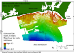
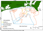
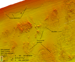
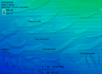
Bathymetry in the H12023 study area ranges from about 0.3 m near shore to 32 m near the southern edge (fig. 12). Several features are visible in the MBES data, including boulders, scour depressions, and modern marine sediments (fig. 13). These features are not mutually exclusive as they overlap in many places, and boundaries are gradational. Boulders are present across much of the northern part of the study area where wave and current energy is generally highest in the survey area and water depths are shallower than 20 m. Only a few boulders are visible in the bathymetry in the deep parts of the study area. Boulders are often found where the sea floor is gravelly and hummocky and modern marine sediments are thin to absent (fig. 14). Many boulders visible in the bathymetric data are several meters across and some are more than 10 m wide. These bouldery and hummocky areas are part of the southern flank of the Point Judith moraine, a submerged segment of the Harbor Hill-Roanoke Point-Charlestown-Buzzards Bay moraine line that trends southeastward from Point Judith, which was deposited about 18,000 years ago (Uchupi and others, 2001). Scour depressions, which commonly border or grade into the bouldery areas, have coarser grained, often rippled, floors about 0.5 m below the finer grained surrounding sea floor (figs. 14 and 15). Scour depressions are in two areas, one near the coast and another offshore on the deep, southern side of the study area. The near-shore scour depressions form a band trending parallel to the shore with a ragged northern edge that forms shoreward-reaching, northward-tapering extensions about 100 m in length and tens of meters in width (figs. 13 and 14). Morang and McMaster (1980) postulated that these near-shore features were formed by rip currents, rip currents and waves, or storm-generated along-shelf flow. Alternatively, Oakley and others (2009) described these features as cross-shore swaths created by downwelling-driven, seaward flows. The scour depressions on the southern side of the study area are mostly elongate in either a north-south or east-west direction. The north-south oriented depressions tend to be smaller (hundreds of meters long by tens of meters wide) than the east-west oriented depressions, which are more than 1 kilometer in length and up to hundreds of meters wide (fig. 15). Modern marine sediments cover the sea floor near the coast and offshore in areas that are undisturbed and featureless. The sediments commonly border scour depressions and form erosional outliers within the depressions. These sediments are finer grained than the scour depressions and areas with boulders. Textural differences of these features are discussed further in the Sediments section of this report. |

![]() U.S. Department of the Interior |
U.S. Geological Survey
U.S. Department of the Interior |
U.S. Geological Survey
URL: http://pubsdata.usgs.gov/pubs/of/2013/1003/html/bathy.html
Page Contact Information: GS Pubs Web Contact
Page Last Modified: Wednesday, 21-Aug-2013 14:40:47 EDT