U.S. Geological Survey Open-File Report 2013–1003
Sea-Floor Geology in Northeastern Block Island Sound, Rhode Island
![]() Title |
List of Figures |
Conversion Factors |
Abstract |
Introduction |
Setting |
Methods |
Bathymetry |
Sidescan Sonar |
Sediments |
Bottom Photography |
GIS Data Catalog |
Summary |
Acknowledgments |
References |
Contacts |
Index
Title |
List of Figures |
Conversion Factors |
Abstract |
Introduction |
Setting |
Methods |
Bathymetry |
Sidescan Sonar |
Sediments |
Bottom Photography |
GIS Data Catalog |
Summary |
Acknowledgments |
References |
Contacts |
Index
 |
||
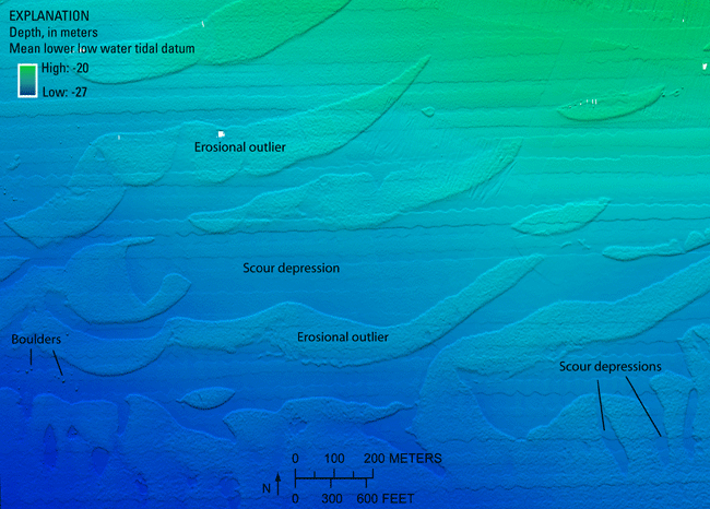
Figure 15. Detailed multibeam-bathymetric image of scour depressions and erosional outliers (positive local relief) in the southern part of the study area. In these deep areas, large depressions and outliers tend to trend east-west, but the small, deep depressions trend north-south. Also visible are a few boulders within a scour depression. Location shown in figure 12. |
||

![]() U.S. Department of the Interior |
U.S. Geological Survey
U.S. Department of the Interior |
U.S. Geological Survey
URL: http://pubsdata.usgs.gov/pubs/of/2013/1003/html/fig15.html
Page Contact Information: GS Pubs Web Contact
Page Last Modified: Wednesday, 21-Aug-2013 16:01:45 EDT

