Open-File Report 2017–1098
AbstractMultiyear remote sensing mapping of the normalized difference vegetation index (NDVI) was carried out as an indicator of live biomass composition of the Phragmites australis (hereafter Phragmites) marsh in the lower Mississippi River Delta (hereafter delta) from 2014 to 2017. Maps of NDVI change showed that the Phragmites condition was fairly stable between May 2014 and July 2015. From July 2015 to April 2016 NDVI change indicated Phragmites suffered a widespread decline in the live biomass proportion. Between April and September 2016, most marsh remained unchanged from the earlier period or showed improvement; although there were pockets of continued decline scattered throughout the lower delta. From September 2016 to May 2017 a pronounced and widely exhibited decline in the condition of Phragmites marsh again occurred throughout the lower delta. This final NDVI change mapping supported field observations of Phragmites decline during the same period. IntroductionIn early spring 2017, the U.S. Geological Survey (USGS) initiated a project to investigate whether remote sensing data could be used to map the observed widespread decrease in the health of Phragmites australis (hereafter Phragmites) marshes in the lower Mississippi River Delta (hereafter delta). These marshes have been dominated by Phragmites for the past several decades (White and others, 2004). By using satellite optical data, the USGS produced a map indicating the relative loss of live biomass in delta vegetation from May 2016 to May 2017. The loss map was found to provide a good representation of what was generally believed to be the spatial distribution of Phragmites dieback. Given that positive outcome, the mapping was extended back to summer 2014. The purpose of the 2014–16 mapping was to assess whether the May 2016 to May 2017 decrease in live biomass was an abnormal event. The preevent mapping also provided insight into the timing of the dieback onset (that is, fall 2016 or earlier). The change of Phragmites live biomass was estimated with the normalized difference vegetation index (NDVI) calculated from satellite red and near-infrared optical data. The NDVI is an adaption based on the concept of Tucker (1979) that decreases the influences of a changing atmosphere while providing a useful estimate of the vegetation live biomass component (Vogelmann and others, 1993; Huete and others, 1999; He and others, 2007; Ramsey and others, 2015). In marsh where live and total (dead plus live) biomass covaries, NDVI can be used to estimate total biomass (Ramsey and others, 2015). Limitations of mapping changes in the live biomass component of the marsh with NDVI are most often the same as limitations associated with optical remote sensing in wetland environments. Subcanopy flooding can influence the magnitude of the optical data recorded by the remote sensing system. Where the marsh canopy fully covers the ground and the water depth above the ground surface is low compared to the canopy height, the effect of subsurface flooding on the optical data will likely be minimal. Even in less full cover marsh canopies, if the soil surface is dark in color, bare, and water saturated or near saturated, subcanopy flooding will for the most part only exclude the contribution from the submerged marsh biomass. Shallower flooding will cause less biomass to be excluded, resulting in a minimal influence on the optical data. Another limitation is related to the nondiscriminatory basis of NDVI mapping. In cases where a dominantly monotypic marsh is declining thereby allowing higher light penetration to the subcanopy, secondary vegetation can become established. The addition of the invading vegetation changes the optical data used in calculating the NDVI; however, the change is not discernible from that caused by a change in the live biomass proportion of the original marsh. If the NDVI magnitude or phenology differs between the original marsh and the invading vegetation, the change will likely become apparent as the invading vegetation dominates the image pixel. Between the onset of marsh decline and dominance of the invading new vegetation, there can be some ambiguity in interpretation of NDVI. Enhanced detection of these possible replacement scenarios is possible with increased NDVI mapping frequency or by including canopy structure mapping, such as obtained with radar mapping. Increased NDVI mapping frequency will capture an abnormal change in the marsh temporal trajectory caused by the replacement, whereas radar mapping can capture a change in marsh structure conducive for replacement. Either method can be applied to provide an early warning indicator of replacement of the marsh canopy by opportunist vegetation. MethodsThe sequential change of NDVI from 2014 to 2017 was based on nominally cloud-free Landsat-8 Operational Land Imager (OLI) and Sentinel-2 MultiSpectral Instrument (MSI) images collected as best possible within the May to September full growth period (table 1). Only the April 2016 OLI image was collected outside that period. Useful Sentinel data were available from spring 2016 onward. The image data were corrected to the top of atmosphere (TOA) in order to further minimize any possible atmospheric corruption of the calculated NDVI. Table 1. Satellite image acquisition dates and respective sensor ground resolution. [m, meter; OLI, Operational Land Imager; MSI, MultiSpectral Instrument]
NDVI was calculated per 30-meter (m) OLI and 10-m MSI pixel in a floating point format (real numbers). As an initial approximation, NDVI was estimated to range between 0 and 1. Negative NDVI values were set to 0, and values greater than 1 were set to 1. Negative NDVI values were most commonly associated with water or flooded marsh. Ideally, 0 represented the lack of live biomass in the vegetation canopy, and 1 represented a fully live vegetation canopy. The change in NDVI from one date to the next was used to indicate the percent change of the live biomass component per image pixel. NDVI change was calculated as the difference of the later date from the earlier date. For instance, the NDVI difference from May 2014 to July 2015 was calculated as the NDVI from May 20, 2014, minus the NDVI from July 26, 2015. The calculated NDVI difference was output in a 16-bit format that allowed display of both increase and decrease of live biomass on a single map. The consistency of the NDVI mapping was tested by using the April 2016 OLI, May 2016 MSI, and September 2016 OLI NDVI maps. The test involved the comparison of the April–September 2016 and the May–September 2016 NDVI difference maps. One question included in the testing was whether the April NDVI date provided an adequate representation of a full growth Phragmites marsh. A second question included in the testing was whether OLI and MSI NDVI maps offered similar representations of the Phragmites marsh live proportion. NDVI Change and the NDVI TrajectoryMapping sequential NDVI changes also contains a possible inherent bias. Each sequential change is based on one of the two NDVI images used to calculate change; there is a memory effect from one step to the next. The change is quantifiably correct; however, the change magnitude and direction are dependent on the outcome of the previous change. To verify the veracity of the change maps, NDVI trajectory curves were constructed for 2014–17. NDVI values from 3- by 3-pixel windows were extracted from six sites within the Phragmites coverage (shown in fig. 3A and table 2) from each of the six image dates (site 4 lies just outside the mapped Phragmites coverage). Fairly homogeneous regions of increase, decrease, and no change on the September 2016 to May 2016 NDVI change map were targeted and NDVI values tracked over the six dates from 2014 to 2017. The nine NDVI values composing the 3- by 3-pixel window for each site and date were averaged and one standard deviation calculated. Table 2. Sample site locations used in the trajectory plots shown in figure 4. [UTM, Universal Transverse Mercator]
Subcanopy Flooding and NDVINDVI can be altered by subcanopy flooding, thereby affecting both the change results and the trajectory results. Information on the above-marsh surface water levels at the time of the image collections was obtained from monitoring stations maintained within the Louisiana Coastwide Reference Monitoring System (CRMS; https://www.lacoast.gov/crms2/home.aspx ). This information allowed the assessment of possible corruption of the NDVI by subcanopy flooding. Data were downloaded from two CRMS stations located in U.S. Fish and Wildlife Service (USFWS) Delta National Wildlife Refuge (NWR); one station is on a site near the main channel of the Mississippi River, and the other is on the eastern outer extent of the delta (see fig. 3A for station id). Results and DiscussionNDVI differences from May 2016 to May 2017 indicated widespread change in the proportion of live biomass throughout the delta extent. To focus on change associated with Phragmites, the study was confined to the lower delta, which is dominated by Phragmites marsh (fig. 1). Because of the indicated changes in the live biomass proportion from May 2016 to May 2017, the NDVI change mapping was extended back to 2014 to capture the onset of Phragmites decline. 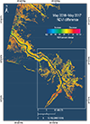
Figure 1. Map showing overview of normalized difference vegetation index (NDVI) change in the lower Mississippi River Delta from May 2016 to May 2017 based on Sentinel-2 MultiSpectral Instrument (MSI) images. Colors indexed in the legend represent the percent increase or decrease of NDVI from the earlier to the later date. Darker orange to red indicates low (0–20 percent), red to pink indicates medium (20–40 percent), and pink indicates high (greater than 40 percent) decrease in the proportion of live biomass composing the vegetation canopy. Conversely, light orange indicates low, yellow to green indicates medium, and green to turquoise indicates high increase in the live biomass proportion. The box outlines the area of interest shown in figure 2. The NDVI change maps for the lower delta from July 2015 to April 2016 displayed a widespread and relatively high decrease from the nearly unchanged May 2014 to July 2015 NDVI period (figs. 2A and B). Between April 2016 and September 2016, the earlier decrease largely recovered throughout the lower delta (fig. 2C). That recovery was further substantiated by NDVI change calculated between the May 2016 MSI NDVI map and the same September 2016 OLI NDVI map (fig. 2D). The April–September 2016 and May–September 2016 NDVI change maps were highly similar. In addition to reinforcing the recovery, the similar results for approximately the same time period reinforced the comparability of NDVI mapping based on OLI or MSI data. The close comparison also showed that full growth was well represented in April and, importantly, demonstrated the fidelity of the NDVI calculation and the dependability of NDVI as an indicator of Phragmites status. A second decline was recorded between September 2016 and May 2017 that, although not as ubiquitous or severe as the first decline in spring 2016, was substantial. 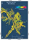
Figure 2. Maps showing changes in normalized difference vegetation index (NDVI) of vegetation within the lower Mississippi River Delta from 2014 to 2017 based on Landsat-8 Operational Land Imager (OLI) and Sentinel-2 MultiSpectral Instrument (MSI) image data. A, May 2014 to July 2015. B, July 2015 to April 2016. C, April 2016 to September 2016. D, May 2016 to September 2016. E, September 2016 to May 2017. F, May 2016 to May 2017. Colors indexed in the legend represent the percent increase or decrease of NDVI from the earlier to the later date. One of the concerns in the NDVI mapping was that the connection between Phragmites and NDVI change was not confirmed. A 2011 map of Phragmites occurrences resolved that concern for the USFWS Delta NWR and its surroundings where Phragmites was dominant (fig. 3A). The 2014–17 NDVI change maps exhibited the high variability in the Phragmites landscape as reflected in the entire lower delta (figs. 3B–F). Opportunistic invasion by other plants into the subcanopy, such as Colocasia esculenta (elephant ear), in areas of Phragmites decline could have confused the NDVI association to Phragmites. In the case of elephant ear or various forms of floating vegetation, the bright green subcanopy replacement would be revealed as an abnormally high NDVI with respect to the mixed live-dead Phragmites canopy. Cursory inspection of the series of NDVI maps indicated that possible replacement may have occurred; however, those occurrences were few and scattered. Although further study is needed to account for possible replacement influences on NDVI during Phragmites decline, the multiyear mapping indicates that NDVI changes reflected proportional changes in Phragmites live biomass. 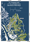
Figure 3. Maps showing U.S. Fish and Wildlife Service Delta National Wildlife Refuge (NWR) (white outline on all graphics). A, An overlay of the 2011 occurrence of Phragmites australis in and in the vicinity of the Delta NWR (Phragmites map from William Jones and Jason Dugas, U.S. Geological Survey Wetland and Aquatic Research Center). The remaining maps are closeups of normalized difference vegetation index (NDVI) changes in the Delta NWR (shown in fig. 2) displaying NDVI change from B, May 2014 to July 2015, C, July 2015 to April 2016, D, April 2016 to September 2016, E, September 2016 to May 2017, and F, May 2016 to May 2017. Colors indexed in the legend represent the percent increase or decrease of NDVI from the earlier to the later date. The May–September 2016 NDVI change is not included because of its high similarity to the April–September 2016 NDVI change map. All NDVI trajectory plots confirm the high stability of Phragmites from 2014 to 2015, and all but two trajectories (sites 5, 6) exhibit the high to moderate NDVI decrease from July 2015 to April 2016 (fig. 4). Three of the sites reflect minor changes from April to May 2016 (sites 1, 4, 6), whereas in two (sites 2, 5) of the remaining sites the April–May 2016 change is part of a decreasing or increasing trend through September 2016. From May to September 2016 the trajectories are grouped evenly into those increasing (sites 1, 2, 4) or decreasing (sites 3, 5, 6). That grouping in trajectories is a prelude to what happened by May 8, 2017. Sites that underwent a decrease from May to September 2016 had an NDVI increase by May 8, 2017 (sites 3, 5, 6), whereas the converse was true for sites that underwent an NDVI increase from May to September 2016 (sites 1, 2, 4). 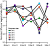
Figure 4. Graph showing normalized difference vegetation index (NDVI) trajectories of Phragmites australis marsh sites in or near the U.S. Fish and Wildlife Service Delta National Wildlife Refuge. Each point on the trajectory plot represents the NDVI mean and standard deviation at each site at times of image collections (see “Methods” section for details). Colors are used to distinguish site trajectories. See fig. 3A and table 2 for site locations. Water levels referenced to the marsh surface obtained from CRMS stations (fig. 3A) at the times of the image collections ranged from less than 10 centimeters (cm) to about 43 cm (0.1–0.43 m) at the times of the image collections (table 3). The water levels were fairly low in comparison to the height of a mature, established Phragmites marsh (3–4.5 m), diminishing the possibility of subcanopy flooding influencing the NDVI calculations. In addition, the changing water levels did not show a clear alignment with the NDVI changes noted in the 2014–17 NDVI change mapping and trajectory analysis. Higher water levels did not consistently track lower NDVI magnitudes, and conversely, lower water levels were not noticeably associated with higher NDVI magnitudes. Table 3. Above-marsh surface water levels at the times of image collections. [CRMS, Coastwide Reference Monitoring System; m, meter]
*Adjusted water elevation referenced to marsh surface (m). **No data are available for April 2016. ***Data on CRMS site have been updated only to April 25, 2017. The progression of changes in Phragmites marsh as indicated by changes in NDVI and its association with the live biomass proportion offers a different scenario than represented solely by the single year May 2016 to 2017 NDVI change map. The NDVI progression from 2014 suggests that the change observed beginning in fall 2016 may have been a result of cumulative declines from 2015 onward. Following the relative stability from spring 2014 to summer 2015, the most severe decline occurred in spring 2016. That decline was followed by a period of largely mixed recovery and no change to fall 2016. The second decline was recorded during the final period from fall 2016 to spring 2017. The NDVI trajectory plots help remove the ambiguity caused by the sequential calculation of change represented in the NDVI change maps; however, the determination of a cumulative effect was not obtainable in the short period of time analyzed. To more fully understand the dynamic nature of the Phragmites marsh and recognize abnormal change would require further research. A more extensive historical NDVI mapping record including a higher sample frequency could provide answers not available from this short period of mapping. In addition, beginning in 2016 the frequency of NDVI mapping could be increased dramatically by incorporating both OLI and MSI satellite sensors. Inclusion of radar mapping could also help define structural changes in Phragmites as a supplemental indicator of abnormal change leading to Phragmites marsh decline. SummaryThe U.S. Geological Survey documented the reported decline in Phragmites australis (hereafter Phragmites) marsh from May 2016 to May 2017 in the lower Mississippi River Delta by using normalized difference vegetation index (NDVI) mapping based on remote sensing optical data. While the mapping based on NDVI’s widely used relation with the live biomass substantiated the decline in live biomass proportion, the level of decline was low to moderate and scattered within a marsh exhibiting fair stability from May 2016 to May 2017. The reported decline associated with Phragmites, however, described a more severe and widespread detrimental change in Phragmites condition. To balance the report and the NDVI mapping results, the mapping was extended back to 2014. Maps of NDVI change from 2014 to 2017 showed that a fairly stable period in Phragmites condition occurred between May 2014 and July 2015. NDVI plots from 2014 to 2017 also supported the early stable period. In contrast, from July 2015 to April 2016 there was a substantial and widespread decline in the live biomass proportion that was associated with Phragmites. Between April and September 2016 the decline continued in some areas scattered throughout the lower delta; however, the large portion of marsh was unchanged or improved. A similar result was obtained in a second NDVI change mapping from May to September 2016. From September 2016 to May 2017 a pronounced decline in the condition of Phragmites marsh was again widely exhibited throughout the lower delta. NDVI mapping of changes in Phragmites marsh and its association with the live biomass proportion suggests that the change observed beginning in fall 2016 may have been a result of cumulative declines from 2015 onward. Construction of NDVI trajectory plots helped to remove the ambiguity caused by the sequential calculation of change; however, the cumulative nature of the changes was not determinable from analysis of this short time record. A more extensive historical NDVI mapping record including a higher sample frequency could provide answers not available from this short period of mapping. In addition, beginning in 2016 the frequency of NDVI mapping could be increased dramatically by incorporating both Landsat-8 Operational Land Imager and Sentinel-2 MultiSpectral Instrument satellite sensors. Inclusion of radar mapping could also help define structural changes in Phragmites as a supplemental indicator of abnormal change leading to Phragmites marsh decline. ReferencesHe, Y., Guo, X., and Wilmshurst, J.F., 2007, Comparison of different methods for measuring leaf area index in a mixed grassland: Canada Journal of Plant Science, v. 87, p. 803–813. Huete, A., Justice, C., and Leeuwen, W., 1999, MODIS vegetation index (MOD 13) algorithm theoretical basis document, version 3: Accessed May 27, 2015, at http://modis.gsfc.nasa.gov/data/atbd/atbd_mod13.pdf. Ramsey, E., III, Rangoonwala, A., Jones, C.E., and Banister, T., 2015, Marsh canopy leaf area and orientation calculated for improved marsh structure mapping: Photogrammetric Engineering and Remote Sensing, v. 81, no. 10, p. 807–816. Tucker, C.J., 1979, Red and photographic infrared linear combinations for monitoring vegetation: Remote Sensing of Environment, v. 8, p. 127–150. Vogelmann, J.E., Rock, B.N., and Moss, D.M., 1993, Red edge spectral measurements from sugar maple leaves: International Journal of Remote Sensing, v. 14, no. 8, p. 1563–1575. White, D.A., Hauber, D.P., and Hood, C.S., 2004, Clonal differences in Phragmites australis from the Mississippi River Delta: Southeastern Naturalist, v. 3, no. 3, p. 531–544. Suggested CitationRamsey, E.W., III, and Rangoonwala, Amina, 2017, Mapping the change of Phragmites australis live biomass in the lower Mississippi River Delta marshes: U.S. Geological Survey Open-File Report 2017–1098, https://doi.org/10.3133/ofr20171098. |
First posted July 28, 2017 |
|||||||||||||||||||||||||||||||||||||||||||||||||||||||||||||||||||

![]() U.S. Department of the Interior |
U.S. Geological Survey
U.S. Department of the Interior |
U.S. Geological Survey
URL: http://pubsdata.usgs.gov/pubs/of/2017/1098/index.html
Page Contact Information: GS Pubs Web Contact
Page Last Modified: Tuesday, 01-Aug-2017 16:32:25 EDT
