FISC - St. Petersburg
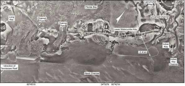
Figure 58. Aerial photo (1991) shows sinuous intra-island tidal channels in areas around Lower Matecumbe Key (middle Keys; from Lidz et al., 2003; compare with Fig. 57 and interpreted Benthic Ecosystems for Tile 3). White dotted line marks seaward edge of a nearshore rock ledge. Note width of the ledge relative to that of Lower Matecumbe Key. Also note tidal-delta sediments within channels and at channel edges. The four tidal channels in this photo are believed to represent bedrock depressions through which a forked Pleistocene river exited Florida Bay when the shelf was exposed (Davies, 1980).
|
Can't see the printable PDF version? Get the free Adobe Acrobat® Reader. |

![]() U.S. Department of the Interior |
U.S. Geological Survey
U.S. Department of the Interior |
U.S. Geological Survey
URL: [disc] /pubs/pp/2007/1751/professional-paper/tile3/figures/fig58.html
Page Contact Information: Feedback
Page Last Modified: December 01, 2016 @ 04:13 PM (JSS)
