USGS - science for a changing world

FISC - St. Petersburg

Coastal & Marine Geology Program > Center for Coastal & Watershed Studies > Professional Paper 1751

Systematic Mapping of Bedrock and Habitats along the Florida Reef Tract—Central Key Largo to Halfmoon Shoal (Gulf of Mexico)

USGS Professional Paper 1751

by Barbara H. Lidz, Christopher D. Reich, and Eugene A. Shinn

Introduction:
Table of Contents
Project Overview
Project Objective
Geologic Setting
Primary Datasets
Primary Products - Overview Maps & Evolution Overview:
Bedrock Surface map.
Introduction
Depth to Pleistocene Bedrock Surface
Reef & Sediment Thickness
Benthic Ecosystems & Environments
Sedimentary Grains in 1989
Summary Illustration Index Map
Evolution Overview
Tile-by-Tile Analysis
Satellite image of the Florida Keys showing location of tiles.
Organization of Report
Tiles: 1, 2, 3, 4,
5, 6, 7/8, 9/10,
11
Summary
Acknowledg-
ments
References
Disclaimer
Related
Publications

Tile 2

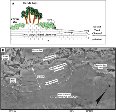
Nearshore Rock Ledge: Aerial photographs and field observations show that a nearshore rock ledge borders the seaward side of the Florida Keys and forms a major regional shallow (0 to ~4 m) seabed structure (e.g., Fig. 46A, 46B; see Benthic Ecosystems map). The ledge has a 30-cm-high scarp at its seaward edge. The scarp marks the boundary between inshore hardbottom communities and biota that inhabit the muddy, seagrass-covered environment of Hawk Channel (see Benthic Ecosystems for Tile 2; Marszalek, 1977; Lidz et al., 2003). The ledge is clearly visible in aerial photographs used to illustrate other geomorphic trends discernible in the nearshore seabed floor.

(A) Drawing shows cross section of nearshore rock ledge as presently inferred. (B) Aerial photo (1975) shows seaward extent of the nearshore rock ledge (dotted line) in the area of Tavernier Key bank and Plantation Key.
Figure 46. (A) Drawing shows cross section of nearshore rock ledge as presently inferred (modified from Lidz et al., 2006). (B) Aerial photo (1975) shows seaward extent of the nearshore rock ledge (dotted line) in the area of Tavernier Key bank and Plantation Key (upper Keys, Fig. 42B; from Lidz et al., 2003). Note the ledge is much wider than Plantation Key. Maximum extent of the ledge anywhere along the seaward side of the keys is approximately 2.5 km. Its landward edge is coincident with the shoreline of the keys. Sands (dashed lines) of adjacent Snake Creek tidal delta and sandy lime mud of Tavernier Key bank cover parts of the ledge. Sands are thinner on the shoreward part that harbors the inshore hardbottom community (Table 2). The seaward side of the mud bank at Tavernier Key is lined with a narrow zone of coralline red algae (dark ribbon on right edge of dashed line), like the seaward edge of Rodriguez Key bank (see Benthic Ecosystems for Tile 1 and Tile 2). The most extensive habitat on the shelf is the shelf-wide seagrass/lime-mud community that lines the floor of Hawk Channel (see pie chart). [larger version]

A theory holds that the ledge may represent the seaward extent of the Key Largo Limestone reef and Miami Limestone oolite that form the Florida Keys (Lidz et al., 2006). Those authors have shown that the ledge is erosional and, through correlation of the 4-m depth of its seaward scarp with the local sea-level curve (Fig. 41A), has been forming as a ledge over the past 4 ka. The ledge is a maximum of 2.5 km wide, its smooth surface slopes gently landward, and its landward edge is the shoreline.

A single core obtained from the ledge off Key Largo recovered coral facies similar to that of the Key Largo Limestone (Reich et al., 2002). That core was drilled for installation of water-monitoring wells (Reich, 1996) and was not dated. Verification of ledge composition and age through coring and dating is needed keys-wide. Lacking those data, however, all other current evidence including new evidence for interpretation of the ledge points to ongoing land loss in the Florida Keys during the past 4 ka—a rate of ~6.25 m/100 yr (Lidz et al., 2006). Coupled with a rate of sea-level rise that is projected to increase from a present rate at Key West of 0.38 m/100 yr (Fig. 41B) to 0.88 m/110 yr (Albritton et al., 2001), the distance, duration, and constancy of erosion have significant implications and ramifications for the dense population of the keys.

Coastal & Marine Geology Program > Center for Coastal & Watershed Studies > Professional Paper 1751

Accessibility FOIA Privacy Policies and Notices

Take Pride in America logo USA.gov logo U.S. Department of the Interior | U.S. Geological Survey
URL: [disc] /pubs/pp/2007/1751/professional-paper/tile2/nearshore-rock.html
Page Contact Information: Feedback
Page Last Modified: December 01, 2016 @ 04:13 PM (JSS)