FISC - St. Petersburg
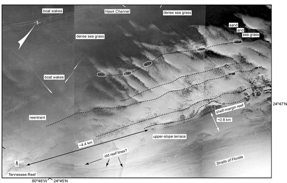
Figure 67. Aerial photo (1975) shows seafloor morphology in vicinity of Tennessee Reef (middle Keys, Fig. 56B; from Lidz et al., 2003; compare with interpreted Benthic Ecosystems for Tile 3). 'Tripod' symbol represents location of Tennessee Reef Light. Bedrock depth below sea level on the shelf behind Tennessee Reef is similar to bedrock depth under Hawk Channel (see Bedrock Surface map). This area of the shelf margin may represent a major low-elevation bedrock connection to four of the inshore channels on either side of Lower Matecumbe Key (Figs. 57, 58). Coral-rock ridges can be traced along the shelf margin (dotted lines) and at the seaward edge of the upper-slope terrace (arrows). Ovals mark areas of patch reefs on the landward ridge. Note absence of outlier reefs on the upper-slope terrace.
|
Can't see the printable PDF version? Get the free Adobe Acrobat® Reader. |

![]() U.S. Department of the Interior |
U.S. Geological Survey
U.S. Department of the Interior |
U.S. Geological Survey
URL: [disc] /pubs/pp/2007/1751/professional-paper/tile3/figures/fig67.html
Page Contact Information: Feedback
Page Last Modified: December 01, 2016 @ 04:13 PM (JSS)
