FISC - St. Petersburg
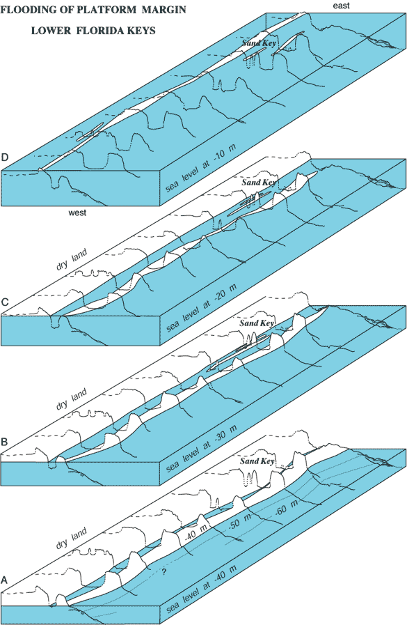
Figure 111. Block diagrams of the Pleistocene shelf-edge surface off the lower Keys are constructed from outlines of pre-1997 interpreted seismic profiles (i.e., the profiles show three, not four, tracts of outlier reefs; Figs. 89, 91B; from Lidz et al., 1997b). (A-D) Diagrams show reef-and-trough system and geomorphic changes during Holocene sea-level rise. Distance between profiles is not to scale. Distance along margin between end profiles is ~65 km. Shelf-edge morphologies varied with rising sea level from long, tall, broad limestone-island ridges and shallow lagoons to low narrow islands surrounded by deep (25 m) water. Direction of wave-induced water flow was probably westward, as it is today (indicated by sediment-free troughs). Crest of shelf-edge reef on average is at or below the shelf surface, indicating lack of an offshore protective rock-island barrier when sea level was <10 m lower than present.
|
Can't see the printable PDF version? Get the free Adobe Acrobat® Reader. |

![]() U.S. Department of the Interior |
U.S. Geological Survey
U.S. Department of the Interior |
U.S. Geological Survey
URL: [disc] /pubs/pp/2007/1751/professional-paper/tile7-8/figures/fig111.html
Page Contact Information: Feedback
Page Last Modified: December 01, 2016 @ 04:14 PM (JSS)
